
Sayles (Barnsdale): Difference between revisions
m (Text replacement - "VicinitySuffix=|" to "") |
mNo edit summary |
||
| (125 intermediate revisions by 2 users not shown) | |||
| Line 1: | Line 1: | ||
{{PlaceNamesItemTop|Lat=53.6125|Lon=-1.2135|AdministrativeDivision=Yorkshire|Vicinity=''c.'' 275 m N of New Close Lane and ''c.'' 775 m E of the A1?|Type=Area|Interest=Literary locale|Status=Defunct|Demonym=|Riding=West|GreaterLondon=|Year=1500|Aka=|Century=|Cluster1=Barnsdale|Cluster2=|Cluster3=|Image=sayles-barnsdale-google-earth-street-view-3.jpg|Postcards=|ExtraCat1=Place-names in Gest of Robyn Hode|ExtraCat2=|ExtraCat3=|ExtraCat4=|ExtraCat5=|ExtraLink1=Sayles Plantation (Barnsdale)|GeopointPrefix=Near |GeopointSuffix= ?|StatusSuffix=|DatePrefix=''c. ''|DateSuffix=}} | |||
{{#display_map:{{#var:Coords}}|width=34%}}<div class="pnMapLegend"> | {{#display_map:{{#var:Coords}}~{{#replace:{{PAGENAME}}|'|'}}|width=34%|enablefullscreen=yes}}<div class="pnMapLegend">The Sayles</div> | ||
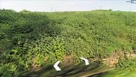
[[File: | [[File:{{#var:Image}}|thumb|500px|At New Close Lane, off the A1. The high ground here may have been (part of) the Sayles / Google Earth Street View.]] | ||
[[File:sayles-barnsdale-google-earth-street-view-1.jpg|thumb|500px|At or near the Sayles, above New Close Lane / Google Earth Street View.]] | |||
[[File: | [[File:sayles-barnsdale-google-earth-street-view-2.jpg|thumb|500px|At or near the Sayles, above New Close Lane / Google Earth Street View.]] | ||
[[File:sayles- | |||
<div class="no-img"> | <div class="no-img"> | ||
In | <p id="byline">By Henrik Thiil Nielsen, 2013-06-30. Revised by {{#realname:{{REVISIONUSER}}}}, {{REVISIONYEAR}}-{{REVISIONMONTH}}-{{REVISIONDAY2}}; includes information and materials from David Hepworth and Robert Lynley.''</p> | ||
In the [[Gest of Robyn Hode]], Robin Hood sends Little John, Scathlock and Much the Miller's Son to a place in [[Barnsdale (Doncaster)|Barnsdale]] called 'the Sayles', where they are to look out for a traveller they can 'invite' to dinner with Robin Hood — an experience that will likely prove expensive if the guest is wealthy. This is significant since the Sayles are an obscure locality which is unlikely to have been known outside the immediate area. The fact that it is included in the ''Gest'' shows that the writer knew this part of the West Riding well. | |||
=== Quotations | Dobson and Taylor in the 1970s, on discovering an extant locality named Sayles Plantation just southeast of Wentbridge, jumped to the conclusion that this was the Sayles figuring in the ''Gest''. However, as explained on IRHB's page on [[Sayles Plantation (Barnsdale)]] this cannot be correct, for it leads to a major, hitherto overlooked, inconsistency in parts of the plot. Instead, as was pointed out already in the 1890s, we must look for the Sayles in an area about 4 km south of Sayles Plantation and Wentbridge. | ||
<div class="blockthorny">[c. 1500:]<br/> | |||
<p class="after-toc">In addition to the matter discussed below, it is important for an appreciation of the importance of Barnsdale to the Robin Hood tradition to read the entries on Barnsdale itself and other Robin Hood-related localities in or near Barnsdale, for which see the page on the [[Barnsdale place-name cluster|Barnsdale place-name cluster.]] Especially important in the present context is the page on [[Sayles Plantation (Barnsdale)]].</p> | |||
== Sayles in the records == | |||
The following is a fairly full list of known records referring to a locality in or adjacent to Barnsdale named 'Sayles'. It could have been extended somewhat if we had included references to persons in the Barnsdale area surnamed de Sayles or similar.<ref>An undated deed refers to plots of land in Campsall owned by a William del Saylis: {{:Ellis, A S 1892a}}, see p. 233.</ref> | |||
* 1225. Close Roll entry (PRO, C54/3, m. 31). The Priory of Worksop to take full seisin of 36 acres of land in "Sailles" after William son of Thomas, who formerly held it, had abjured the realm because of murder.<ref>{{:Hardy, Thomas Duffus 1833a}}, p. 17; not seen; information courtesy Robert Lynley. Also {{:Dodsworth, Roger 1892a}}, see p. 65; {{:Hepworth, David 2003a}}.</ref> | |||
* 1298. Inquistion Post Mortem, mentions 'Skelbrok by le Sailes' and refers to a windmill in Skelbrooke.<ref name="midgleysayles">[http://midgleywebpages.com/saylis.html An alternative location for 'Saylis' of the Geste] at Tim Midgley's website</ref> | |||
* 1329. Privy seal warrant dated June 23:<ref>PRO, C.81/163/2703. Not seen, but cf. {{:Dobson, Richard Barrie 1976a}}, p. 24 n. 3; {{:Hepworth, David 2003a}}.</ref> robbery committed at "le Saylles" at some prior date. | |||
* 1329. Close Roll entry of this robbery case.<ref>{{:Isaacson, Robert F 1891a}}, p. 432. {{:Hepworth, David 2003a}}.</ref> Discussed below. | |||
* 1346/7 (account of aid for knighting the Black Prince). Sayles in the possession of Richard, son of Adam de Sayles, who contributed 4''s.'' towards the knighting.<ref name="hunter15n">{{:Hunter, Joseph 1852a}}, p. 15 n. 7.</ref> | |||
* 1449. Cartulary of Worksop Priory lands compiled by prior Charles Fleming lists the lands granted in 1225.<ref name="hepworth">{{:Hepworth, David 2003a}}.</ref> | |||
* 1539-47. Sayles listed in a terrier of this date.<ref name="hepworth"/> | |||
* 1577. Bernard's survey of the Duchy of Lancaster lands in the county of York.<ref name="hunter15n"/> | |||
* 1688. Kirk Smeaton glebe terrier lists an "acre in the Sailes".<ref>Dobson & Taylor (1972) (as above), p. 18 & n. 61; {{:Smith, Albert Hugh 1961a}}, vol. II, p. 52.</ref> | |||
* 17th century confirmation of land grant noted in Joseph Hunter's MS notes on Robin Hood.<ref name="hepworth"/> | |||
* 1857 terrier refers to a "Sailes Close".<ref name="hepworth"/> | |||
<p class="after-ul">Dobson & Taylor note that the last two items certainly refer to the present [[Sayles Plantation (Barnsdale)]]. The 1228 and the two 1329 items certainly do not. | |||
== Robbery at Sayles == | |||
John Maddicott discovered in the mid-1970's that a robbery had been committed at a place called the Sayles some time before June 23, 1329.<ref>Dobson & Taylor (1976) (as above), p. 24 n. 3.</ref> None of the historians who have discussed this has cited the actual wording of the Privy Seal warrant or the Close Roll entry. I have not seen either yet, but in the meantime I note that the Close Roll calendar summarizes the 1329 entry as follows: | |||
<blockquote>The like [i.e. commission of oyer and terminer] to John Travers, Thomas Deyvill, and Adam de Hoperton on complaint by William de Felton that William Frere of Doncaster, William le Taverner of Doncaster, Thomas Frere, John Frere, Nicholas de Tykhull, Matilda de Clayton, John le Carter and others assaulted him at Skelbrook, co. York, and carried away his goods.<ref>{{:Isaacson, Robert F 1891a}}, p. 432.</ref></blockquote> | |||
The extent of the area to which the name 'Barnsdale' was applied has varied during the centuries, so let us instead take the more precisely located [[Barnsdale Bar (Barnsdale)|Barnsdale Bar]] as our point of reference and note that of the alleged culprits the two Williams came from [[Doncaster]], c. 12.5 km SSE of Barnsdale Bar, Nicholas came from Tickhill (c. 21.5 km SSE), while Matilda came from Clayton (c. 8.5 km SSW of Barnsdale Bar). Sayles near [[Wentbridge]] would have been c. 4 km further away from home for all of them. In fact they did not commit this crime quite so far from their homes, for the deed was said to have been done at Skelbrook, c. 1.5 km south of Barnsdale Bar. According to the Privy Seal warrant, Sayles was the crime scene. This poses a problem if we follow Dobson & Taylor in locating Sayles near [[Wentbridge]], for a crime committed in the immediate vicinity of the village of [[Wentbridge]] would hardly be said in the record to have been committed at Skelbrooke, a village or hamlet c. 5 km away. That a crime was said to have been committed near both Skelbrooke and Sayles makes much better sense if there was in fact a Sayles near Skelbrooke. It is also significant that, as Hepworth notes,<ref name="hepworth"/> people surnamed Sayles once lived in or near Skelbrooke. | |||
As noted on the page on [[Barnsdale (Doncaster)|Barnsdale]], the name 'Barnsdale' must originally have referred to the valley of the river Skell, just south of [[Barnsdale Bar (Barnsdale)|Barnsdale Bar]], but in late medieval and early modern times it referred to a less well-defined area that had [[Barnsdale Bar (Barnsdale)|Barnsdale Bar]] near or at its southern boundary. Neither location tallies with the notion of the outlaws surveying Barnsdale from the Sayles near [[Wentbridge]], and therefore Dobson & Taylor, followed by Holt, suggested that the author of the [[Gest of Robyn Hode|''Gest'']] had got the facts slightly wrong and used "Barnsdale" to refer to the area near [[Wentbridge]] or to a larger area that included [[Wentbridge]]. The problem here is that a writer who knew such an obscure locality as the Sayles would presumably also have known which area locals referred to by the name Barnsdale. He is not very likely to have deliberately misrepresented such facts. Moreover, as is made clear in our discussion of [[Sayles Plantation (Barnsdale)|Sayles Plantation]], this locality cannot be the Sayles figuring in the ''Gest'', so we have to look for another locality, and as is clear from the discussion of the robbery at the Sayles c. 1329, this must have happened in the area to which the name 'Barnsdale' usually referred, a few kilometres south of [[Wentbridge]] and [[Sayles Plantation (Barnsdale)|Sayles Plantation.]] Once this is realized, there is no longer any reason to 'relocate' Barnsdale or extend it towards the north. | |||
== Sayles in Campsall == | |||
In 1892 Yorkshire local history buff Richard Holmes wrote: | |||
<div class="plainquote">The Sayles is a high land in the township and parish of Campsall, 200 ft. above sea level, at a rise of 120 ft. from the immediate neighbourhood. It is close to Barnsdale in Skelbrook [...] The Sayles is mentioned in the Ballad of Robin Hood, lines 76 and 830. As Robin Hood’s men looked from the Sayles towards Barnsdale, the Knight was coming by a "dune way," just such a way as still leads the traveller past the front of Woodfield House, between the Sayles and the road. The view from the Sayles is extensive, and includes beyond [''sic''] Market Weighton. This bit of local colouring (unless there is another Sayles in Nottinghamshire) serves to identify the Sayles, near Barnsdale and Skelbrook, as the scene of this exploit of the bold outlaw. A family probably taking their name from this place has been resident in Pontefract and the neighbourhood for the last six hundred years.<ref>{{:Dodsworth, Roger 1892a}}, see p. 65 n. 37. IRHB's brackets.</ref></div> | |||
The 'Ballad of Robin Hood' should be the ''Gest of Robyn Hode'', the 'dune way' a 'derne strete',<ref>''Gest'', st. 21:2.</ref> and it should be noted also that the substance of the passage is a hypothesis rather than the statement of fact it appears to be. Holmes seems to imply that the name 'Sayles,' ''tout court'' or preceded by the definite article, was in current use locally as a name for the high ground in question, but presumably local historians such as Joseph Hunter or Holmes himself, the compiler(s) of the Ordnance Survey name book for the area or 20th century place-name researchers would have found evidence of this if it were the case. What Holmes gives us is instead a conclusion based on a close reading of the ''Gest'', intimate knowledge of the topography of the area and minor localities there whose names included the element 'Sayles' or 'Sales'. He had almost certainly reached it at least six years earlier, for there can be little doubt that the productive and knowledgeable writer on Yorkshire local history, Richard Holmes, should be identified with the 'R. H. H.', resident at Pontefract, who contributed a note on 'Robin Hood's Chapel in Barnsdale' to ''Notes and Queries'' in 1886.<ref>{{:H, R H 1886a}}.</ref> His central concern there was to show that the church now known as St Michael & All Angels in Skelbrooke is the one referred to by Robin Hood in st. 440 of the ''Gest'': | |||
{{PlainQuote|I made a chapel in Bernysdale<br> | |||
that semely is to se<br> | |||
it is of Mary Magdaleyne<br> | |||
and thereto wolde I be[.]}} | |||
<p>He noted that {{PlainQuote|[i]n its immediate neighbourhood/behind Woodfield House, Campsalls [''sic''], two hundred feet above sea-level, according to the six-inch Ordnance Survey of Yorkshire—Robin Hood's well, on the great North Road, close by, being but eighty feet—there is a high land called to this day Sayles Wood, the view from which extends to beyond Market Weighton. It is this hill which is probably referred to in the poem at lines 76 and 830. As Robin Hood's men looked from the Sayles towards Barnsdale, the knight was coming by a dune way, just such a way as leads the traveller past the front of Woodfield House, as Sayles Wood is behind.<ref>{{:H, R H 1886a}}.</ref>}} | |||
This is important, but unfortunately these passage were too well tucked away for most later historically oriented Robin Hood experts to notice. It is, however, significant that Tim Midgley reached similar conclusions, without at the time knowing Richard Holmes's note. Both these gentlemen worked from first-hand knowledge of the area, which I certainly cannot claim to have. However, based on my knowledge of the ''Gest''<ref>My fairly intense interest in this poem began in 1976, fourteen years before I handed in my MA thesis on it. See {{:Nielsen, Henrik Thiil 1990a}}.</ref> and O.S. maps of the area I had begun to suspect something similar before I came across Tim Midgley's page on the Sayles or, much later, Holmes's notes. I believe this convergence of opinion counts for something. | |||
The Sayles in the ''Gest'' are an area 'up to' which the outlaws are sent by Robin Hood to keep the Great North Road under observation. The area above the present New Close Lane fits that description very well. Dobson and Taylor note in their review article on Holt's monograph<ref>{{:Dobson, Richard Barrie 1983a}}, p. 213; {{:Holt, James Clarke 1982a}}.</ref> that persuasive as Holt's chapter on the physical setting of the ballads is: | |||
<blockquote>One is perhaps a little less persuaded that when in the 21st stanza of the first fytte of the ''Gest'', Little John and his companions 'loked in to Bernysdale, Bi a dern strete' there 'can be no doubt' that they were 'looking at Wentbridge lying in the deeply cut valley of the Went'. The dangers of being quite so certain are nicely illustrated by the previous stanza of the ''Gest'' which makes Little John and his two companions look east and west, exactly the points of the compass to which one would ''not'' look if wishing to intercept travellers on the great north road.</blockquote> | |||
A medieval trio of (more or less fictional) outlaws on the lookout in the area suggested by Holmes and Midgley would have had a reasonable expectation of spotting a traveller somewhere to the east or west but might instead have found, as they looked into Barnsdale, i.e. in a generally southerly direction, that a lonesome and distraught knight came riding along a street or lane in the area. In view of the phrase 'derne strete', a hidden street, the Great North Road itself is perhaps not so likely to be the road on which the knight is supposed to have been travelling, but the first few tens of metres of the present New Close Lane, coming from the Great North Road (now the A1), fit the bill very well. While someone travelling there would be moving roughly east or west, observers posted on the high ground north of New Close Lane would see him as they looked (down) towards the south, a situation well in keeping with the scene in the ''Gest''. This stretch of New Close Lane is in fact nowadays a 'derne strete', but whether it was so in the latter half of the 15th century, when the ''Gest'' was most likely written, is a question only archaeologists could hope to answer. | |||
The high ground just above Barnsdale Summerhouse and Woodfield House, 65 to 75 m above sea level, 200 to 500 m south or south-west of [[Barnsdale Bar (Barnsdale)|Barnsdale Bar]], is in or near the area locals would have referred to as Barnsdale at the time the [[Gest of Robyn Hode|''Gest'']] was written. This is the neighbourhood where [[Robin Hood's Well (Barnsdale)|Robin Hood's Well]], [[Robin Hood's Stone (Barnsdale)|Robin Hood's Stone]] and the [[Bishop's Tree (Barnsdale)|Bishop's Tree]] are or were located. In the area below [[Barnsdale Bar (Barnsdale)|Barnsdale Bar]], there were roads leading east and west from the roughly north/south-oriented Great North Road, so from the high ground nearby one was essentially looking down at a four-way intersection. There can now be little doubt that it was a locality in this area the author of the [[Gest of Robyn Hode|''Gest'']] had in mind when he referred to the Sayles. Since this was the area where the robbery in ''c.'' 1329 was committed, it is also natural that the crime should have been stated to have occurred near Skelbrooke, less than 1.5 km away. The 6" O.S. map of the area published in 1854, based on an 1849 survey (see Maps section below), includes a Sales Wood and Sales Quarry in this area, north of New Close Lane and south of Woodfield Road between Barnsdale Summerhouse and Woodfield House. Sales Quarry and Wood do not appear on modern maps, but "Sales Quarry" is indicated on 25" O.S. maps dated 1893 and 1932 as well as on 6" O.S. maps from 1930 and 1950. Incidentally, a Sales Lane, still in existence, is found on a 6" O.S. map published in 1854, at a point (53.637686,-1.036904) ''c.'' 4.75 km NNE of Kirk Bramwith and ''c.'' 13 km ENE of [[Barnsdale Bar (Barnsdale)|Barnsdale Bar]].<ref>[http://maps.nls.uk/view/102345106#zoom=6&lat=9980&lon=11437&layers=BT 6" O.S. map ''Yorkshire'' 265 (1854; surveyed 1849-50).]</ref> | |||
As Midgley notes, there are still people surnamed Sayles in the area, and Sayles Plantation, Sales Wood and Sales Quarry may all have been named after owners/occupiers. A Plantation is of course at some point a new planting and may well be named after the person who plants it, a quarry may be named after a family that works it, a wood after a family that owns it. 'Sayles' as the first element of a compound place-name may be a possessive (in modern orthography: <i>Sayle's</i> or <i>Sayles'</i>); 'the Sayles', on the other hand, is a common noun in the nominative plural, and the definite article ('the' or 'le') tells us the noun was used with reference to specific objects. Thus 'Sayles' originated as a common noun that became a place-name that became a surname that became an element of place-names such as 'Sales Quarry'. Had Hunter known of any of these Sayles and thought they might be ancient place-names, he would no doubt have mentioned this. That he did not know of the Quarry and Wood is a little surprising; they appeared on the O.S. map which was published in 1854, a couple of years after his seminal pamphlet on Robin Hood was published, but based on a survey carried out already in 1849. Were these names in such restricted local use that Hunter did not know of them? Hunter, born and bred in Sheffield, was not in the strictest sense a local. On the other hand there is perhaps good reason he had not heard about Sayles Planation near [[Wentbridge]], for as Midgley notes, the O.S. map of 1853 (surveyed 1848-49) labels it "Smeaton Pasture Wood", not "Sayles Plantation".<ref>See [https://maps.nls.uk/view/102345058#zoom=6&lat=2025&lon=4525&layers=BT 6" O.S. map Yorkshire Sheet 250 (1853, surveyed 1848-49) (at NLS).]</ref> It had become Sayles Plantation by 1904.<ref>See [https://maps.nls.uk/view/100948436#zoom=5&lat=2842&lon=4842&layers=BT 6" O.S. map Yorkshire Sheet CCL.SW (1907, revised 1904) (at NLS).]</ref> | |||
While there can be little doubt the Sayles was situated in the general area we are here discussing, i.e. just south of [[Barnsdale Bar (Barnsdale)|Barnsdale Bar]], the fact that 'Sayles' was used as a surname means we cannot simply identify it with one of the rather small localities whose 19th century names included the element 'Sayles', for they may have been named after owners/occupiers surnamed Sayles. Whatever the exact location, it is clear from Robin Hood's command to his men to 'walke up to the Saylis | And so to Watlinge Strete' that the Sayles must have been quite close to the Great North Road, which was here, as in several other localities, known as [[Watling Street (Barnsdale)|Watling Street.]] The ground on the south side of Woodfield Road reaches an altitude of as much as 75 metres, sloping gently down to about 70 metres near Summerhouse Farm, where the incline becomes more marked as the ground falls to less than 50 metres at the western end of New Close Lane, near the A1, falling to 10 metres south of Skellow. The best suggestion I can make is that the Sayles were located in the vicinity of Summerhouse Farm. While we may well imagine the knight riding along the late medieval incarnation of New Close Lane, it should be noted that there are several other lanes in Campsall and Burghwallis the outlaws might have surveyed from the suggested location. | |||
== The etymology of 'Sayles' == | |||
According to the English Place-Name Society's volume on this area, 'Sayles' is a reflex of ''salh'', "willow, sallow (Latin 'salix')".<ref>{{:Smith, Albert Hugh 1961a}}, vol. II, p. 52. Also see [https://www.oed.com/view/Entry/170065 ''OED'', sallow, ''n.'']</ref> Midgley notes that there are willows on the banks of the Skell, the little river which forms the southern boundary of Skellow. Osier beds are indicated on the 1854 map. He also notes an alternative to this: the name may refer to the wings of a windmill. A windmill existed at Skelbrook by 1298.<ref>See above and see [http://midgleywebpages.com/saylis.html An alternative location for 'Saylis' of the Geste] at Tim Midgley's website.</ref> This is an interesting suggestion, especially with Much the Miller's Son among the outlaws sent to the Sayles to look out for wayfarers. The noun 'sail' is found referring to the wing of a windmill in a work written 1265 and preserved in an MS dating from before 1350. Among the ME forms recorded are some that are quite compatible with known forms of the place-name, such as 'Sayles'.<ref>See [https://www.oed.com/view/Entry/169803 ''OED'', 'sail, ''n.1'', 5] (£) and especially [https://quod.lib.umich.edu/m/middle-english-dictionary/dictionary/MED39218 ''MED'', seil(e, ''n.'', 5 (a).]</ref> | |||
{{PlaceNamesItemAllusionsAndRecords}} | |||
== Quotations == | |||
<div class="blockthorny"><p>[''Gest''; ''c.'' 1500:]<br/> | |||
And walke up to the Saylis<br/> | And walke up to the Saylis<br/> | ||
And so to Watlinge Strete<br/> | And so to Watlinge Strete<br/> | ||
And wayte after some unketh gest<br/> | And wayte after some unketh gest<br/> | ||
Up chaunce ye may them mete<ref>[[ | Up chaunce ye may them mete<ref>''[[Gest of Robyn Hode]]'', st. 18.</ref> | ||
< | </p> | ||
<p> | |||
They wente up to the Saylis<br/> | They wente up to the Saylis<br/> | ||
These yeman all three<br/> | These yeman all three<br/> | ||
They loked est, they loked weest<br/> | |||
They might no man see<br/> | They might no man see<br/> | ||
< | </p> | ||
<p> | |||
But as they loked in to Bernysdale<br/> | But as they loked in to Bernysdale<br/> | ||
Bi a derne strete<br/> | Bi a derne strete<br/> | ||
Then came a knight ridinghe<br/> | Then came a knight ridinghe<br/> | ||
Full sone they gan hym mete<ref>'' | Full sone they gan hym mete<ref>''[[Gest of Robyn Hode]]'', sts. 20-21.</ref><br/> | ||
< | </p> | ||
<p> | |||
And walke up under the Sayles<br/> | And walke up under the Sayles<br/> | ||
And to Watlynge strete<br/> | And to Watlynge strete<br/> | ||
And wayte after such unketh gest<br/> | And wayte after such unketh gest<br/> | ||
Up-chaunce ye may them mete<ref>'' | Up-chaunce ye may them mete<ref>''[[Gest of Robyn Hode]]'', st. 209.</ref><br/> | ||
< | </p> | ||
<p> | |||
They went up to the Sayles<br/> | They went up to the Sayles<br/> | ||
These yemen all three<br/> | These yemen all three<br/> | ||
They loked est, they loked west<br/> | They loked est, they loked west<br/> | ||
They might no man se<br/> | They might no man se<br/> | ||
< | </p> | ||
<p> | |||
But as they loked in Bernysdale<br/> | But as they loked in Bernysdale<br/> | ||
By the hye waye<br/> | By the hye waye<br/> | ||
Than were they ware of two blacke monkes<br/> | Than were they ware of two blacke monkes<br/> | ||
Eche on a good palferay<ref>''Gest'', st. 212-13.</ref></div> | Eche on a good palferay<ref>''[[Gest of Robyn Hode]]'', st. 212-13.</ref></p></div> | ||
== Gazetteers == | |||
* {{:Dobson, Richard Barrie 1976a}}, p. 308. | * {{:Dobson, Richard Barrie 1976a}}, p. 308. | ||
== MS sources == | |||
* PRO, C.81/163/2703, a privy seal warrant, dated June 23, 1329; not seen, but cf. Dobson & Taylor (1976), p. 24 n. 3. | * PRO, C.81/163/2703, a privy seal warrant, dated June 23, 1329; not seen, but cf. Dobson & Taylor (1976), p. 24 n. 3. | ||
=== | == Printed sources == | ||
* {{:Isaacson, Robert F 1891a}}, p. 432 | * {{:Dodsworth, Roger 1892a}}, see p. 65 | ||
* {{:Hardy, Thomas Duffus 1833a}}, p. 17; not seen; information courtesy Robert Lynley | * {{:H, R H 1886a}} | ||
* {{:Isaacson, Robert F 1891a}}, p. 432 | |||
* {{:Hardy, Thomas Duffus 1833a}}, p. 17; not seen; information courtesy Robert Lynley | |||
* {{:Smith, Albert Hugh 1961a}}, vol. II, p. 52. | * {{:Smith, Albert Hugh 1961a}}, vol. II, p. 52. | ||
== Maps == | |||
These maps show the area in which Sayles must have been located. | |||
* [http://maps.nls.uk/view/125648127#zoom=4&lat=3252&lon=3958&layers=BT 25" O.S. map ''Yorkshire'' CCLXIV.7 (1893; surveyed 1891)] | * [http://maps.nls.uk/view/125648127#zoom=4&lat=3252&lon=3958&layers=BT 25" O.S. map ''Yorkshire'' CCLXIV.7 (1893; surveyed 1891)] | ||
* [http://maps.nls.uk/view/125648133#zoom=4&lat=3754&lon=3523&layers=BT 25" O.S. map ''Yorkshire'' CCLXIV.7 (1932; rev. 1930)] | * [http://maps.nls.uk/view/125648133#zoom=4&lat=3754&lon=3523&layers=BT 25" O.S. map ''Yorkshire'' CCLXIV.7 (1932; rev. 1930)] | ||
* [https://maps.nls.uk/geo/explore/#zoom=16&lat=53.64759&lon=-1.25539&layers=168&b=5 25" O.S. map ''Yorkshire'' CCL.14 (1906; rev. 1904)] (georeferenced) | |||
* [http://maps.nls.uk/view/125648130#zoom=4&lat=3414&lon=3622&layers=BT 25" O.S. map ''Yorkshire'' CCLXIV.7 (1906; surveyed 1904)] | * [http://maps.nls.uk/view/125648130#zoom=4&lat=3414&lon=3622&layers=BT 25" O.S. map ''Yorkshire'' CCLXIV.7 (1906; surveyed 1904)] | ||
* [http://maps.nls.uk/view/102345103#zoom=6&lat=5888&lon=8482&layers=BT 6" O.S. Map ''Yorkshire'' 264 (1854, surveyed 1849)] | * [http://maps.nls.uk/view/102345103#zoom=6&lat=5888&lon=8482&layers=BT 6" O.S. Map ''Yorkshire'' 264 (1854, surveyed 1849)] | ||
* [ | * [https://maps.nls.uk/view/100948904#zoom=4&lat=1418&lon=1244&layers=BT 6" O.S. map ''Yorkshire'' CCLXIV.NE (1894; surveyed 1891)] | ||
* [ | * [https://maps.nls.uk/geo/explore/#zoom=16&lat=53.61372&lon=-1.21410&layers=6&b=5 6" O.S. map ''Yorkshire'' CCLXIV.NE (1907; rev. 1904)] (georeferenced) | ||
* [https://maps.nls.uk/view/100948901#zoom=4&lat=1656&lon=970&layers=BT 6" O.S. map ''Yorkshire'' CCLXIV.NE (1907; rev. 1904)] | |||
* [https://maps.nls.uk/view/100948898#zoom=5&lat=1773&lon=1657&layers=BT 6" O.S. map ''Yorkshire'' CCLXIV.NE (1930, rev. 1930)] | |||
* [https://maps.nls.uk/view/100948895#zoom=5&lat=1657&lon=1465&layers=BT 6" O.S. map ''Yorkshire'' CCLXIV.NE (1950, rev. 1948).] | |||
=== Maps of other localities discussed in the text === | |||
==== Sales Lane ==== | |||
* [http://maps.nls.uk/view/102345106#zoom=6&lat=9980&lon=11437&layers=BT 6" O.S. map ''Yorkshire'' 265 (1854; surveyed 1849-50)] | |||
==== Smeaton Pasture Wood/Sayles Plantation ==== | |||
* [https://maps.nls.uk/view/102345058#zoom=6&lat=2025&lon=4525&layers=BT 6" O.S. map Yorkshire Sheet 250 (1853, surveyed 1848-49)] | |||
* [http://maps.nls.uk/view/100948436 6" O.S. map Yorkshire Sheet CCL.SW (1907, revised 1904) (at NLS).] | |||
== Discussion == | |||
* {{:Dobson, Richard Barrie 1972a}}, see pp. 17-18 | * {{:Dobson, Richard Barrie 1972a}}, see pp. 17-18 | ||
* {{:Dobson, Richard Barrie 1976a}}, see pp. 21-23, 24 & n. 3 | * {{:Dobson, Richard Barrie 1976a}}, see pp. 21-23, 24 & n. 3 | ||
* {{:Dobson, Richard Barrie 1983a}} | |||
* {{:Hepworth, David 2003a}} | * {{:Hepworth, David 2003a}} | ||
* {{:Hunter, Joseph 1852a}} | * {{:Hunter, Joseph 1852a}} | ||
* [http://midgleywebpages.com/saylis.html An alternative location for 'Saylis' of the Geste] at Tim Midgley's website. | * [http://midgleywebpages.com/saylis.html An alternative location for 'Saylis' of the Geste] at Tim Midgley's website. | ||
=== | == Background == | ||
* [ | * {{:Ellis, A S 1892a}}, see p. 233 | ||
* [https://quod.lib.umich.edu/m/middle-english-dictionary/dictionary/MED39218 ''MED'', seil(e, ''n.'', 5 (a)] | |||
* [https://www.oed.com/view/Entry/169803 ''OED'', 'sail, ''n.1'', 5] (£) | |||
* [https://en.wikipedia.org/wiki/Joseph_Hunter_(antiquarian) Wikipedia: Joseph Hunter (antiquarian).] | |||
{{PlaceNamesItemAlsoSee}} | |||
== Notes == | |||
<references/> | <references/> | ||
</div> | |||
< | <div id="gallery"> | ||
{{ | {{ImageGalleryIntroduction}} | ||
<gallery widths="195px"> | <gallery widths="195px"> | ||
sayles-barnsdale-google-earth-street-view-3.jpg|At New Close Lane, off the A1. The high ground here may have been (part of) the Sayles / Google Earth Street View. | |||
sayles-barnsdale-google-earth-street-view-2.jpg|New Close Lane further east of the Great North Road, SE of the probable location of the Sayles / Google Earth Street View. | |||
sayles-barnsdale-google-earth-street-view-1.jpg|New Close Lane further east of the Great North Road, SE of the probable location of the Sayles / Google Earth Street View. | |||
sayles-barnsdale-google-earth-street-view-4.jpg|The west end of New Close Lane is now a 'derne strete', but who knows how it looked more than 500 years ago? / Google Earth Street View. | |||
sayles-barnsdale-google-earth-street-view-5.jpg|High ground above New Close Lane / Google Earth Street View. | |||
</gallery> | </gallery> | ||
</div> | |||
{{ | {{PlaceNamesItemNavigation}} | ||
Latest revision as of 14:41, 25 October 2022
| Locality | |
|---|---|
| Coordinate | Near 53.6125, -1.2135 ? |
| Adm. div. | West Riding of Yorkshire |
| Vicinity | c. 275 m N of New Close Lane and c. 775 m E of the A1? |
| Type | Area |
| Interest | Literary locale |
| Status | Defunct |
| First Record | c. 1500 |


By Henrik Thiil Nielsen, 2013-06-30. Revised by Henrik Thiil Nielsen, 2022-10-25; includes information and materials from David Hepworth and Robert Lynley.
In the Gest of Robyn Hode, Robin Hood sends Little John, Scathlock and Much the Miller's Son to a place in Barnsdale called 'the Sayles', where they are to look out for a traveller they can 'invite' to dinner with Robin Hood — an experience that will likely prove expensive if the guest is wealthy. This is significant since the Sayles are an obscure locality which is unlikely to have been known outside the immediate area. The fact that it is included in the Gest shows that the writer knew this part of the West Riding well.
Dobson and Taylor in the 1970s, on discovering an extant locality named Sayles Plantation just southeast of Wentbridge, jumped to the conclusion that this was the Sayles figuring in the Gest. However, as explained on IRHB's page on Sayles Plantation (Barnsdale) this cannot be correct, for it leads to a major, hitherto overlooked, inconsistency in parts of the plot. Instead, as was pointed out already in the 1890s, we must look for the Sayles in an area about 4 km south of Sayles Plantation and Wentbridge.
In addition to the matter discussed below, it is important for an appreciation of the importance of Barnsdale to the Robin Hood tradition to read the entries on Barnsdale itself and other Robin Hood-related localities in or near Barnsdale, for which see the page on the Barnsdale place-name cluster. Especially important in the present context is the page on Sayles Plantation (Barnsdale).
Sayles in the records
The following is a fairly full list of known records referring to a locality in or adjacent to Barnsdale named 'Sayles'. It could have been extended somewhat if we had included references to persons in the Barnsdale area surnamed de Sayles or similar.[1]
- 1225. Close Roll entry (PRO, C54/3, m. 31). The Priory of Worksop to take full seisin of 36 acres of land in "Sailles" after William son of Thomas, who formerly held it, had abjured the realm because of murder.[2]
- 1298. Inquistion Post Mortem, mentions 'Skelbrok by le Sailes' and refers to a windmill in Skelbrooke.[3]
- 1329. Privy seal warrant dated June 23:[4] robbery committed at "le Saylles" at some prior date.
- 1329. Close Roll entry of this robbery case.[5] Discussed below.
- 1346/7 (account of aid for knighting the Black Prince). Sayles in the possession of Richard, son of Adam de Sayles, who contributed 4s. towards the knighting.[6]
- 1449. Cartulary of Worksop Priory lands compiled by prior Charles Fleming lists the lands granted in 1225.[7]
- 1539-47. Sayles listed in a terrier of this date.[7]
- 1577. Bernard's survey of the Duchy of Lancaster lands in the county of York.[6]
- 1688. Kirk Smeaton glebe terrier lists an "acre in the Sailes".[8]
- 17th century confirmation of land grant noted in Joseph Hunter's MS notes on Robin Hood.[7]
- 1857 terrier refers to a "Sailes Close".[7]
Dobson & Taylor note that the last two items certainly refer to the present Sayles Plantation (Barnsdale). The 1228 and the two 1329 items certainly do not.
Robbery at Sayles
John Maddicott discovered in the mid-1970's that a robbery had been committed at a place called the Sayles some time before June 23, 1329.[9] None of the historians who have discussed this has cited the actual wording of the Privy Seal warrant or the Close Roll entry. I have not seen either yet, but in the meantime I note that the Close Roll calendar summarizes the 1329 entry as follows:
The like [i.e. commission of oyer and terminer] to John Travers, Thomas Deyvill, and Adam de Hoperton on complaint by William de Felton that William Frere of Doncaster, William le Taverner of Doncaster, Thomas Frere, John Frere, Nicholas de Tykhull, Matilda de Clayton, John le Carter and others assaulted him at Skelbrook, co. York, and carried away his goods.[10]
The extent of the area to which the name 'Barnsdale' was applied has varied during the centuries, so let us instead take the more precisely located Barnsdale Bar as our point of reference and note that of the alleged culprits the two Williams came from Doncaster, c. 12.5 km SSE of Barnsdale Bar, Nicholas came from Tickhill (c. 21.5 km SSE), while Matilda came from Clayton (c. 8.5 km SSW of Barnsdale Bar). Sayles near Wentbridge would have been c. 4 km further away from home for all of them. In fact they did not commit this crime quite so far from their homes, for the deed was said to have been done at Skelbrook, c. 1.5 km south of Barnsdale Bar. According to the Privy Seal warrant, Sayles was the crime scene. This poses a problem if we follow Dobson & Taylor in locating Sayles near Wentbridge, for a crime committed in the immediate vicinity of the village of Wentbridge would hardly be said in the record to have been committed at Skelbrooke, a village or hamlet c. 5 km away. That a crime was said to have been committed near both Skelbrooke and Sayles makes much better sense if there was in fact a Sayles near Skelbrooke. It is also significant that, as Hepworth notes,[7] people surnamed Sayles once lived in or near Skelbrooke.
As noted on the page on Barnsdale, the name 'Barnsdale' must originally have referred to the valley of the river Skell, just south of Barnsdale Bar, but in late medieval and early modern times it referred to a less well-defined area that had Barnsdale Bar near or at its southern boundary. Neither location tallies with the notion of the outlaws surveying Barnsdale from the Sayles near Wentbridge, and therefore Dobson & Taylor, followed by Holt, suggested that the author of the Gest had got the facts slightly wrong and used "Barnsdale" to refer to the area near Wentbridge or to a larger area that included Wentbridge. The problem here is that a writer who knew such an obscure locality as the Sayles would presumably also have known which area locals referred to by the name Barnsdale. He is not very likely to have deliberately misrepresented such facts. Moreover, as is made clear in our discussion of Sayles Plantation, this locality cannot be the Sayles figuring in the Gest, so we have to look for another locality, and as is clear from the discussion of the robbery at the Sayles c. 1329, this must have happened in the area to which the name 'Barnsdale' usually referred, a few kilometres south of Wentbridge and Sayles Plantation. Once this is realized, there is no longer any reason to 'relocate' Barnsdale or extend it towards the north.
Sayles in Campsall
In 1892 Yorkshire local history buff Richard Holmes wrote:
The 'Ballad of Robin Hood' should be the Gest of Robyn Hode, the 'dune way' a 'derne strete',[12] and it should be noted also that the substance of the passage is a hypothesis rather than the statement of fact it appears to be. Holmes seems to imply that the name 'Sayles,' tout court or preceded by the definite article, was in current use locally as a name for the high ground in question, but presumably local historians such as Joseph Hunter or Holmes himself, the compiler(s) of the Ordnance Survey name book for the area or 20th century place-name researchers would have found evidence of this if it were the case. What Holmes gives us is instead a conclusion based on a close reading of the Gest, intimate knowledge of the topography of the area and minor localities there whose names included the element 'Sayles' or 'Sales'. He had almost certainly reached it at least six years earlier, for there can be little doubt that the productive and knowledgeable writer on Yorkshire local history, Richard Holmes, should be identified with the 'R. H. H.', resident at Pontefract, who contributed a note on 'Robin Hood's Chapel in Barnsdale' to Notes and Queries in 1886.[13] His central concern there was to show that the church now known as St Michael & All Angels in Skelbrooke is the one referred to by Robin Hood in st. 440 of the Gest:
I made a chapel in Bernysdale
that semely is to se
it is of Mary Magdaleyne
and thereto wolde I be[.]
He noted that
[i]n its immediate neighbourhood/behind Woodfield House, Campsalls [sic], two hundred feet above sea-level, according to the six-inch Ordnance Survey of Yorkshire—Robin Hood's well, on the great North Road, close by, being but eighty feet—there is a high land called to this day Sayles Wood, the view from which extends to beyond Market Weighton. It is this hill which is probably referred to in the poem at lines 76 and 830. As Robin Hood's men looked from the Sayles towards Barnsdale, the knight was coming by a dune way, just such a way as leads the traveller past the front of Woodfield House, as Sayles Wood is behind.[14]
This is important, but unfortunately these passage were too well tucked away for most later historically oriented Robin Hood experts to notice. It is, however, significant that Tim Midgley reached similar conclusions, without at the time knowing Richard Holmes's note. Both these gentlemen worked from first-hand knowledge of the area, which I certainly cannot claim to have. However, based on my knowledge of the Gest[15] and O.S. maps of the area I had begun to suspect something similar before I came across Tim Midgley's page on the Sayles or, much later, Holmes's notes. I believe this convergence of opinion counts for something.
The Sayles in the Gest are an area 'up to' which the outlaws are sent by Robin Hood to keep the Great North Road under observation. The area above the present New Close Lane fits that description very well. Dobson and Taylor note in their review article on Holt's monograph[16] that persuasive as Holt's chapter on the physical setting of the ballads is:
One is perhaps a little less persuaded that when in the 21st stanza of the first fytte of the Gest, Little John and his companions 'loked in to Bernysdale, Bi a dern strete' there 'can be no doubt' that they were 'looking at Wentbridge lying in the deeply cut valley of the Went'. The dangers of being quite so certain are nicely illustrated by the previous stanza of the Gest which makes Little John and his two companions look east and west, exactly the points of the compass to which one would not look if wishing to intercept travellers on the great north road.
A medieval trio of (more or less fictional) outlaws on the lookout in the area suggested by Holmes and Midgley would have had a reasonable expectation of spotting a traveller somewhere to the east or west but might instead have found, as they looked into Barnsdale, i.e. in a generally southerly direction, that a lonesome and distraught knight came riding along a street or lane in the area. In view of the phrase 'derne strete', a hidden street, the Great North Road itself is perhaps not so likely to be the road on which the knight is supposed to have been travelling, but the first few tens of metres of the present New Close Lane, coming from the Great North Road (now the A1), fit the bill very well. While someone travelling there would be moving roughly east or west, observers posted on the high ground north of New Close Lane would see him as they looked (down) towards the south, a situation well in keeping with the scene in the Gest. This stretch of New Close Lane is in fact nowadays a 'derne strete', but whether it was so in the latter half of the 15th century, when the Gest was most likely written, is a question only archaeologists could hope to answer.
The high ground just above Barnsdale Summerhouse and Woodfield House, 65 to 75 m above sea level, 200 to 500 m south or south-west of Barnsdale Bar, is in or near the area locals would have referred to as Barnsdale at the time the Gest was written. This is the neighbourhood where Robin Hood's Well, Robin Hood's Stone and the Bishop's Tree are or were located. In the area below Barnsdale Bar, there were roads leading east and west from the roughly north/south-oriented Great North Road, so from the high ground nearby one was essentially looking down at a four-way intersection. There can now be little doubt that it was a locality in this area the author of the Gest had in mind when he referred to the Sayles. Since this was the area where the robbery in c. 1329 was committed, it is also natural that the crime should have been stated to have occurred near Skelbrooke, less than 1.5 km away. The 6" O.S. map of the area published in 1854, based on an 1849 survey (see Maps section below), includes a Sales Wood and Sales Quarry in this area, north of New Close Lane and south of Woodfield Road between Barnsdale Summerhouse and Woodfield House. Sales Quarry and Wood do not appear on modern maps, but "Sales Quarry" is indicated on 25" O.S. maps dated 1893 and 1932 as well as on 6" O.S. maps from 1930 and 1950. Incidentally, a Sales Lane, still in existence, is found on a 6" O.S. map published in 1854, at a point (53.637686,-1.036904) c. 4.75 km NNE of Kirk Bramwith and c. 13 km ENE of Barnsdale Bar.[17]
As Midgley notes, there are still people surnamed Sayles in the area, and Sayles Plantation, Sales Wood and Sales Quarry may all have been named after owners/occupiers. A Plantation is of course at some point a new planting and may well be named after the person who plants it, a quarry may be named after a family that works it, a wood after a family that owns it. 'Sayles' as the first element of a compound place-name may be a possessive (in modern orthography: Sayle's or Sayles'); 'the Sayles', on the other hand, is a common noun in the nominative plural, and the definite article ('the' or 'le') tells us the noun was used with reference to specific objects. Thus 'Sayles' originated as a common noun that became a place-name that became a surname that became an element of place-names such as 'Sales Quarry'. Had Hunter known of any of these Sayles and thought they might be ancient place-names, he would no doubt have mentioned this. That he did not know of the Quarry and Wood is a little surprising; they appeared on the O.S. map which was published in 1854, a couple of years after his seminal pamphlet on Robin Hood was published, but based on a survey carried out already in 1849. Were these names in such restricted local use that Hunter did not know of them? Hunter, born and bred in Sheffield, was not in the strictest sense a local. On the other hand there is perhaps good reason he had not heard about Sayles Planation near Wentbridge, for as Midgley notes, the O.S. map of 1853 (surveyed 1848-49) labels it "Smeaton Pasture Wood", not "Sayles Plantation".[18] It had become Sayles Plantation by 1904.[19]
While there can be little doubt the Sayles was situated in the general area we are here discussing, i.e. just south of Barnsdale Bar, the fact that 'Sayles' was used as a surname means we cannot simply identify it with one of the rather small localities whose 19th century names included the element 'Sayles', for they may have been named after owners/occupiers surnamed Sayles. Whatever the exact location, it is clear from Robin Hood's command to his men to 'walke up to the Saylis | And so to Watlinge Strete' that the Sayles must have been quite close to the Great North Road, which was here, as in several other localities, known as Watling Street. The ground on the south side of Woodfield Road reaches an altitude of as much as 75 metres, sloping gently down to about 70 metres near Summerhouse Farm, where the incline becomes more marked as the ground falls to less than 50 metres at the western end of New Close Lane, near the A1, falling to 10 metres south of Skellow. The best suggestion I can make is that the Sayles were located in the vicinity of Summerhouse Farm. While we may well imagine the knight riding along the late medieval incarnation of New Close Lane, it should be noted that there are several other lanes in Campsall and Burghwallis the outlaws might have surveyed from the suggested location.
The etymology of 'Sayles'
According to the English Place-Name Society's volume on this area, 'Sayles' is a reflex of salh, "willow, sallow (Latin 'salix')".[20] Midgley notes that there are willows on the banks of the Skell, the little river which forms the southern boundary of Skellow. Osier beds are indicated on the 1854 map. He also notes an alternative to this: the name may refer to the wings of a windmill. A windmill existed at Skelbrook by 1298.[21] This is an interesting suggestion, especially with Much the Miller's Son among the outlaws sent to the Sayles to look out for wayfarers. The noun 'sail' is found referring to the wing of a windmill in a work written 1265 and preserved in an MS dating from before 1350. Among the ME forms recorded are some that are quite compatible with known forms of the place-name, such as 'Sayles'.[22]
Quotations
[Gest; c. 1500:]
And walke up to the Saylis
And so to Watlinge Strete
And wayte after some unketh gest
Up chaunce ye may them mete[23]
They wente up to the Saylis
These yeman all three
They loked est, they loked weest
They might no man see
But as they loked in to Bernysdale
Bi a derne strete
Then came a knight ridinghe
Full sone they gan hym mete[24]
And walke up under the Sayles
And to Watlynge strete
And wayte after such unketh gest
Up-chaunce ye may them mete[25]
They went up to the Sayles
These yemen all three
They loked est, they loked west
They might no man se
But as they loked in Bernysdale
By the hye waye
Than were they ware of two blacke monkes
Eche on a good palferay[26]
Gazetteers
MS sources
- PRO, C.81/163/2703, a privy seal warrant, dated June 23, 1329; not seen, but cf. Dobson & Taylor (1976), p. 24 n. 3.
Printed sources
- Dodsworth, Roger, compil.; Holmes, Richard, ed. 'Dodsworth Yorkshire Notes: the Wapentake of Osgoldcross [part VI]', Yorkshire Archæological and Topographical Journal, vol. XII, part XLV (1892), pp. 42-77, see p. 65
- H., R. H. 'Robin Hood's Chapel in Barnsdale', Notes & Queries, Series 7, vol. I (1886), p. 64
- Isaacson, R.F., ed.; Morris, G.J., ed.; Lawrence, H.E., ed. Calendar of the Patent Rolls Preserved in the Public Record Office. Edward III. A.D. 1327-1330 (London, 1891), p. 432
- Hardy, Thomas Duffus, ed. Rotuli Litterarum Clausarum in Turri Londinensi asservati (London, 1833-1844), p. 17; not seen; information courtesy Robert Lynley
- Smith, A.H. The Place-Names of the West Riding of Yorkshire (English Place-Name Society, vols. XXX-XXXVII) (Cambridge, 1961-63), vol. II, p. 52.
Maps
These maps show the area in which Sayles must have been located.
- 25" O.S. map Yorkshire CCLXIV.7 (1893; surveyed 1891)
- 25" O.S. map Yorkshire CCLXIV.7 (1932; rev. 1930)
- 25" O.S. map Yorkshire CCL.14 (1906; rev. 1904) (georeferenced)
- 25" O.S. map Yorkshire CCLXIV.7 (1906; surveyed 1904)
- 6" O.S. Map Yorkshire 264 (1854, surveyed 1849)
- 6" O.S. map Yorkshire CCLXIV.NE (1894; surveyed 1891)
- 6" O.S. map Yorkshire CCLXIV.NE (1907; rev. 1904) (georeferenced)
- 6" O.S. map Yorkshire CCLXIV.NE (1907; rev. 1904)
- 6" O.S. map Yorkshire CCLXIV.NE (1930, rev. 1930)
- 6" O.S. map Yorkshire CCLXIV.NE (1950, rev. 1948).
Maps of other localities discussed in the text
Sales Lane
Smeaton Pasture Wood/Sayles Plantation
- 6" O.S. map Yorkshire Sheet 250 (1853, surveyed 1848-49)
- 6" O.S. map Yorkshire Sheet CCL.SW (1907, revised 1904) (at NLS).
Discussion
- Dobson, R.B.; Taylor, J. 'The Medieval Origins of the Robin Hood Legend: a Reassessment', Northern History, vol. 7 (1972), pp. 1-30, see pp. 17-18
- Dobson, R. B., ed.; Taylor, J., ed. Rymes of Robyn Hood: an Introduction to the English Outlaw (London, 1976), see pp. 21-23, 24 & n. 3
- Dobson, R.B., review.; Taylor, John, review. 'Robin Hood of Barnesdale: a Fellow thou has long sought', Northern History, vol. 19 (1983), pp. 210-20
- Hepworth, David. 'Life versus Fiction: A Consideration of Real Northern Outlaws and their Background versus the Early Ballads of Robin Hood' (unpublished paper from the Third Biannual Robin Hood Conference at York, 2003)
- Hunter, Joseph. The Great Hero of the Ancient Minstrelsy of England, "Robin Hood." His Period, Real Character, etc. investigated and perhaps ascertained (Critical and Historical Tracts, No. 4) (London, 1852)
- An alternative location for 'Saylis' of the Geste at Tim Midgley's website.
Background
- Ellis, A. S., ed. 'Yorkshire Deeds [part II]', Yorkshire Archæological and Topographical Journal, vol. XII, part XLVI (1892), pp. 230-62, see p. 233
- MED, seil(e, n., 5 (a)
- OED, 'sail, n.1, 5 (£)
- Wikipedia: Joseph Hunter (antiquarian).
Also see
Notes
- ↑ An undated deed refers to plots of land in Campsall owned by a William del Saylis: Ellis, A. S., ed. 'Yorkshire Deeds [part II]', Yorkshire Archæological and Topographical Journal, vol. XII, part XLVI (1892), pp. 230-62, see p. 233.
- ↑ Hardy, Thomas Duffus, ed. Rotuli Litterarum Clausarum in Turri Londinensi asservati (London, 1833-1844), p. 17; not seen; information courtesy Robert Lynley. Also Dodsworth, Roger, compil.; Holmes, Richard, ed. 'Dodsworth Yorkshire Notes: the Wapentake of Osgoldcross [part VI]', Yorkshire Archæological and Topographical Journal, vol. XII, part XLV (1892), pp. 42-77, see p. 65; Hepworth, David. 'Life versus Fiction: A Consideration of Real Northern Outlaws and their Background versus the Early Ballads of Robin Hood' (unpublished paper from the Third Biannual Robin Hood Conference at York, 2003).
- ↑ An alternative location for 'Saylis' of the Geste at Tim Midgley's website
- ↑ PRO, C.81/163/2703. Not seen, but cf. Dobson, R. B., ed.; Taylor, J., ed. Rymes of Robyn Hood: an Introduction to the English Outlaw (London, 1976), p. 24 n. 3; Hepworth, David. 'Life versus Fiction: A Consideration of Real Northern Outlaws and their Background versus the Early Ballads of Robin Hood' (unpublished paper from the Third Biannual Robin Hood Conference at York, 2003).
- ↑ Isaacson, R.F., ed.; Morris, G.J., ed.; Lawrence, H.E., ed. Calendar of the Patent Rolls Preserved in the Public Record Office. Edward III. A.D. 1327-1330 (London, 1891), p. 432. Hepworth, David. 'Life versus Fiction: A Consideration of Real Northern Outlaws and their Background versus the Early Ballads of Robin Hood' (unpublished paper from the Third Biannual Robin Hood Conference at York, 2003).
- ↑ 6.0 6.1 Hunter, Joseph. The Great Hero of the Ancient Minstrelsy of England, "Robin Hood." His Period, Real Character, etc. investigated and perhaps ascertained (Critical and Historical Tracts, No. 4) (London, 1852), p. 15 n. 7.
- ↑ 7.0 7.1 7.2 7.3 7.4 Hepworth, David. 'Life versus Fiction: A Consideration of Real Northern Outlaws and their Background versus the Early Ballads of Robin Hood' (unpublished paper from the Third Biannual Robin Hood Conference at York, 2003).
- ↑ Dobson & Taylor (1972) (as above), p. 18 & n. 61; Smith, A.H. The Place-Names of the West Riding of Yorkshire (English Place-Name Society, vols. XXX-XXXVII) (Cambridge, 1961-63), vol. II, p. 52.
- ↑ Dobson & Taylor (1976) (as above), p. 24 n. 3.
- ↑ Isaacson, R.F., ed.; Morris, G.J., ed.; Lawrence, H.E., ed. Calendar of the Patent Rolls Preserved in the Public Record Office. Edward III. A.D. 1327-1330 (London, 1891), p. 432.
- ↑ Dodsworth, Roger, compil.; Holmes, Richard, ed. 'Dodsworth Yorkshire Notes: the Wapentake of Osgoldcross [part VI]', Yorkshire Archæological and Topographical Journal, vol. XII, part XLV (1892), pp. 42-77, see p. 65 n. 37. IRHB's brackets.
- ↑ Gest, st. 21:2.
- ↑ H., R. H. 'Robin Hood's Chapel in Barnsdale', Notes & Queries, Series 7, vol. I (1886), p. 64.
- ↑ H., R. H. 'Robin Hood's Chapel in Barnsdale', Notes & Queries, Series 7, vol. I (1886), p. 64.
- ↑ My fairly intense interest in this poem began in 1976, fourteen years before I handed in my MA thesis on it. See Nielsen, Henrik Thiil. The Literary Evidence of the Gest of Robin Hood and the Origins of the Outlaw Tradition (M.A. thesis, University of Copenhagen, 1990).
- ↑ Dobson, R.B., review.; Taylor, John, review. 'Robin Hood of Barnesdale: a Fellow thou has long sought', Northern History, vol. 19 (1983), pp. 210-20, p. 213; Holt, J.C. Robin Hood (London, 1982).
- ↑ 6" O.S. map Yorkshire 265 (1854; surveyed 1849-50).
- ↑ See 6" O.S. map Yorkshire Sheet 250 (1853, surveyed 1848-49) (at NLS).
- ↑ See 6" O.S. map Yorkshire Sheet CCL.SW (1907, revised 1904) (at NLS).
- ↑ Smith, A.H. The Place-Names of the West Riding of Yorkshire (English Place-Name Society, vols. XXX-XXXVII) (Cambridge, 1961-63), vol. II, p. 52. Also see OED, sallow, n.
- ↑ See above and see An alternative location for 'Saylis' of the Geste at Tim Midgley's website.
- ↑ See OED, 'sail, n.1, 5 (£) and especially MED, seil(e, n., 5 (a).
- ↑ Gest of Robyn Hode, st. 18.
- ↑ Gest of Robyn Hode, sts. 20-21.
- ↑ Gest of Robyn Hode, st. 209.
- ↑ Gest of Robyn Hode, st. 212-13.
Image gallery
Click any image to display it in the lightbox, where you can navigate between images by clicking in the right or left side of the current image.
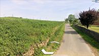
At New Close Lane, off the A1. The high ground here may have been (part of) the Sayles / Google Earth Street View.
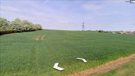
New Close Lane further east of the Great North Road, SE of the probable location of the Sayles / Google Earth Street View.
New Close Lane further east of the Great North Road, SE of the probable location of the Sayles / Google Earth Street View.
The west end of New Close Lane is now a 'derne strete', but who knows how it looked more than 500 years ago? / Google Earth Street View.
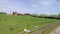
High ground above New Close Lane / Google Earth Street View.

