
Friar Tuck Shop (Chapel St Leonards): Difference between revisions
(Created page with "__NOTOC__{{PnItemTop|Lat=53.216942|Lon=0.336189|AdmDiv=Lincolnshire|Vicinity=E side of S Road, Chapel St Leonards, immediately S of entrance to the Robin Hood Camp (now the Go...") |
m (Text replacement - "No Copy in NLS" to "No copy in NLS") |
||
| (19 intermediate revisions by 2 users not shown) | |||
| Line 1: | Line 1: | ||
__NOTOC__{{ | __NOTOC__{{PlaceNamesItemTop|Lat=53.216243|Lon=0.335334|AdministrativeDivision=Lincolnshire|Vicinity=E side of S Road, Chapel St Leonards, immediately S of entrance to the Robin Hood Camp (now the Golden Palm Resort)|Type=Establishment|Interest=Robin Hood name|Status=Defunct|Demonym=English|Riding=|GreaterLondon=|Year=1958|Aka=|Century=|Cluster1=Chapel St Leonards|Cluster2=|Cluster3=|Image=friar-tuck-shop-chapel-st-leonards-google-earth-street-view.jpg|Postcards=Yes|ExtraCat1=Places named after Friar Tuck|ExtraCat2=|ExtraCat3=|ExtraCat4=|ExtraCat5=|ExtraLink1=|ExtraLink2=|ExtraLink3=|ExtraLink4=|ExtraLink5=|ExtraLinkName1=|ExtraLinkName2=|ExtraLinkName3=|ExtraLinkName4=|ExtraLinkName5=|GeopointPrefix=|GeopointSuffix=|StatusSuffix=|DatePrefix=|DateSuffix=}} | ||
{{#display_map:{{#var:Coords}}~{{#replace:{{PAGENAME}}|'|'}} | {{#display_map:{{#var:Coords}}~{{#replace:{{PAGENAME}}|'|'}}|width=34%|fullscreen=yes}}<div class="pnMapLegend">Site of Friar Tuck Shop, immediately S of entrance to Robin Hood Camp (now Golden Palm Resort.</div> | ||
[[File:{{#var: | [[File:{{#var:Image}}|thumb|right|500px|Site of Friar Tuck Shop / Google Earth Street View.]]<div class="no-img"> | ||
<p id="byline">By Henrik Thiil Nielsen, 2019-05-16. Revised by {{#realname:{{REVISIONUSER}}}}, {{REVISIONYEAR}}-{{REVISIONMONTH}}-{{REVISIONDAY2}}.</p | <p id="byline">By Henrik Thiil Nielsen, 2019-05-16. Revised by {{#realname:{{REVISIONUSER}}}}, {{REVISIONYEAR}}-{{REVISIONMONTH}}-{{REVISIONDAY2}}.</p> | ||
On the south side of the entrance to the [[Robin Hood Camp (Chapel St Leonards)|Robin Hood Camp]] – now the Golden Palm Resort – in Chapel St leonards was a Friar Tuck Shop from at least the 1950s to 1970s. | |||
The shop can be seen on the postcards from 1958 and the 1970s shown in the image gallery below. Immediately South-east of the site is now a [[Maid Marian Pub (Chapel St Leonards)|Maid Marian Pub.]] | |||
== Gazetteers == | == Gazetteers == | ||
* Not included in {{:Dobson, Richard Barrie 1976a}}, pp. 293-311. | * Not included in {{:Dobson, Richard Barrie 1976a}}, pp. 293-311. | ||
<!--== Sources ==--> | <!--== Sources ==--> | ||
== Maps == | == Maps == | ||
Shop not labelled or indicated on maps. | |||
* 25" O.S. map ''Lincolnshire'' LXXVI.7 (''c.'' 1889; surveyed ''c.'' 1888). No | * 25" O.S. map ''Lincolnshire'' LXXVI.7 (''c.'' 1889; surveyed ''c.'' 1888). No copy in NLS | ||
* [https://maps.nls.uk/geo/explore/#zoom=16&lat=53.2198&lon=0.3313&layers=168&b=5 25" O.S. map ''Lincolnshire'' LXXVI.7 (1906; rev. 1905)] (georeferenced) | * [https://maps.nls.uk/geo/explore/#zoom=16&lat=53.2198&lon=0.3313&layers=168&b=5 25" O.S. map ''Lincolnshire'' LXXVI.7 (1906; rev. 1905)] (georeferenced) | ||
* [https://maps.nls.uk/view/114649611#zoom=3&lat=3437&lon=6677&layers=BT 25" O.S. map ''Lincolnshire'' LXXVI.7 (1906; rev. 1905)] | * [https://maps.nls.uk/view/114649611#zoom=3&lat=3437&lon=6677&layers=BT 25" O.S. map ''Lincolnshire'' LXXVI.7 (1906; rev. 1905)] | ||
* [https://maps.nls.uk/geo/explore/#zoom=15&lat=53.2212&lon=0.3289&layers=6&b=5 6" O.S. map ''Lincolnshire'' LXXVI.NE (1907; rev. 1905)] (georeferenced) | * [https://maps.nls.uk/geo/explore/#zoom=15&lat=53.2212&lon=0.3289&layers=6&b=5 6" O.S. map ''Lincolnshire'' LXXVI.NE (1907; rev. 1905)] (georeferenced) | ||
* [https://maps.nls.uk/view/101589326#zoom=4&lat=1884&lon=2385&layers=BT 6" O.S. map ''Lincolnshire'' LXXVI.NE (1888; surveyed 1888)] | * [https://maps.nls.uk/view/101589326#zoom=4&lat=1884&lon=2385&layers=BT 6" O.S. map ''Lincolnshire'' LXXVI.NE (1888; surveyed 1888)] | ||
* [https://maps.nls.uk/view/101589323#zoom=4&lat=1912&lon=2234&layers=BT 6" O.S. map ''Lincolnshire'' LXXVI.NE (1907; rev. 1905)] | * [https://maps.nls.uk/view/101589323#zoom=4&lat=1912&lon=2234&layers=BT 6" O.S. map ''Lincolnshire'' LXXVI.NE (1907; rev. 1905)] | ||
| Line 24: | Line 23: | ||
== Background == | == Background == | ||
* [https://www.goldenpalmresort.co.uk/ Golden Palm Resort] | * [https://www.goldenpalmresort.co.uk/ Golden Palm Resort] | ||
* [https://en.wikipedia.org/wiki/Chapel_St_Leonards Wikipedia: Chapel St Leonards.] | |||
* [https://en.wikipedia.org/wiki/Chapel_St_Leonards Wikipedia: Chapel St Leonards | |||
<!--== Brief mention ==--> | <!--== Brief mention ==--> | ||
{{ | {{PlaceNamesItemAlsoSee}}<!-- | ||
== Notes == | == Notes == | ||
<references/> | <references/>--> | ||
</div> | |||
< | <div id="gallery"> | ||
{{ | {{ImageGalleryIntroduction}} | ||
<gallery widths="195px"> | <gallery widths="195px"> | ||
File:friar-tuck-shop-chapel-st-leonards-google-earth-street-view.jpg|Site of Friar Tuck Shop | File:friar-tuck-shop-chapel-st-leonards-google-earth-street-view.jpg|Site of Friar Tuck Shop / Google Earth Street View. | ||
File:robin-hood-camp-lincspostcards.jpg|Robin Hood Camp / Postcard dated c. 1958, from now defunct site lincolnshirepostcards.co.uk. | File:robin-hood-camp-lincspostcards.jpg|Robin Hood Camp with Friar Tuck shop right / Postcard dated c. 1958, from now defunct site lincolnshirepostcards.co.uk. | ||
File:Photo Precision Ltd 1970a-r.jpg|Robin Hood Camp | File:Photo Precision Ltd 1970a-r.jpg|Robin Hood Camp with Friar Tuck shop right (?1970s) / {{:Photo Precision Ltd 1970a}}; HTN collection. | ||
</gallery> | </gallery> | ||
</div> | |||
{{PlaceNamesItemNavigation}} | |||
{{ | |||
Latest revision as of 00:59, 13 February 2021
| Locality | |
|---|---|
| Coordinate | 53.216243, 0.335334 |
| Adm. div. | Lincolnshire |
| Vicinity | E side of S Road, Chapel St Leonards, immediately S of entrance to the Robin Hood Camp (now the Golden Palm Resort) |
| Type | Establishment |
| Interest | Robin Hood name |
| Status | Defunct |
| First Record | 1958 |

By Henrik Thiil Nielsen, 2019-05-16. Revised by Henrik Thiil Nielsen, 2021-02-13.
On the south side of the entrance to the Robin Hood Camp – now the Golden Palm Resort – in Chapel St leonards was a Friar Tuck Shop from at least the 1950s to 1970s.
The shop can be seen on the postcards from 1958 and the 1970s shown in the image gallery below. Immediately South-east of the site is now a Maid Marian Pub.
Gazetteers
- Not included in Dobson, R. B., ed.; Taylor, J., ed. Rymes of Robyn Hood: an Introduction to the English Outlaw (London, 1976), pp. 293-311.
Maps
Shop not labelled or indicated on maps.
- 25" O.S. map Lincolnshire LXXVI.7 (c. 1889; surveyed c. 1888). No copy in NLS
- 25" O.S. map Lincolnshire LXXVI.7 (1906; rev. 1905) (georeferenced)
- 25" O.S. map Lincolnshire LXXVI.7 (1906; rev. 1905)
- 6" O.S. map Lincolnshire LXXVI.NE (1907; rev. 1905) (georeferenced)
- 6" O.S. map Lincolnshire LXXVI.NE (1888; surveyed 1888)
- 6" O.S. map Lincolnshire LXXVI.NE (1907; rev. 1905)
- 6" O.S. map Lincolnshire LXXVI.NE (c. 1948; rev. 1938)
- 6" O.S. map Lincolnshire LXXVI.NE (1951; rev. 1946).
Background
Also see
Image gallery
Click any image to display it in the lightbox, where you can navigate between images by clicking in the right or left side of the current image.
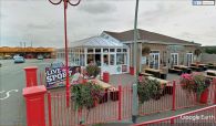
Site of Friar Tuck Shop / Google Earth Street View.
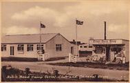
Robin Hood Camp with Friar Tuck shop right / Postcard dated c. 1958, from now defunct site lincolnshirepostcards.co.uk.
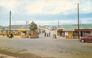
Robin Hood Camp with Friar Tuck shop right (?1970s) / Photo Precision Ltd. Robin Hood Camp, Chapel St. Leonards (R102) ([s.l.], [c. 1970]). Photographic postcard (col.). 139 x 89 mm.; HTN collection.

