Friar Tuck's Hut (Blidworth)
From International Robin Hood Bibliography
| Locality | |
|---|---|
| Coordinate | 53.104092, -1.162023 |
| Adm. div. | Nottinghamshire |
| Vicinity | In Fountain Dale, SE corner of Harlow Wood, c. 1.3 km N of Ravenshead |
| Type | Building |
| Interest | Robin Hood name |
| Status | Extant |
| First Record | 1994 |
| A.k.a. | Friar Tuck's Shelter |
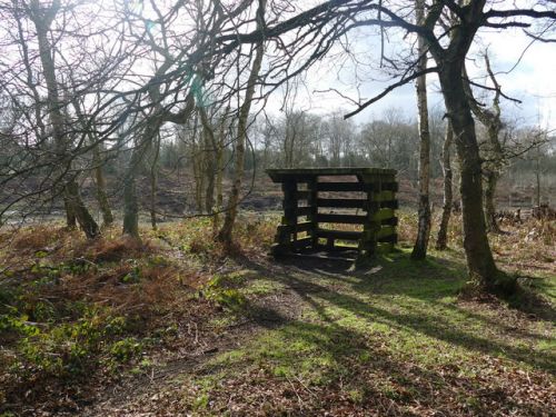
Friar Tuck's Hut.

Friar Tuck's Hut or Shelter. It seems a little on the small side for the rotund friar / Graham Hogg, 22 Feb. 2016, Creative Commons.
By Henrik Thiil Nielsen, 2020-10-09. Revised by Henrik Thiil Nielsen, 2021-01-07.
Friar Tuck's Hut, also known a Friar Tuck's Shelter, is a small wooden structure in Fountain Dale, at the south-east corner of Harlow Wood, not quite 1.5 km north of Ravenshead.
Friar Tuck's Hut hardly merits a detour. It must be the most unimpressive sight on the Robin Hood Way or any other walking route in England. While it looks much too recent to have been around in the jovial friar's day – if there ever was such a day – Robin's rotund recruit could hardly be squeezed into it. A British Heritage Travel article published first published in May 1998 briefly notes this
relic associated with one of the most memorable tales in the Robin Hood legend. At approximately the halfway point of the walk stands a crudely built wooden shelter known as Friar Tuck's Hut. Its age and significance are not known, but Friar Tuck is said to have lived just a short distance up the path, and the hut stands on the spot where Robin supposedly first met the jolly friar, and where they had their famous altercation when Robin tried to cross the river.[1]
Gazetteers
- Not included in Dobson, R. B., ed.; Taylor, J., ed. Rymes of Robyn Hood: an Introduction to the English Outlaw (London, 1976), pp. 293-311.
Sources
- British Heritage Travel: Robin Hood's merry England, by Dirk Arneson, May 1998
- Nottingham Wayfarers' Rambling Club; Price, Roland, introd. The Robin Hood Walks: A Comprehensive Guide to Walks in Robin Hood Country including the Third Edition of the Guide to the Full Route of Nottinghamshire's First Recreational Footpath, The Robin Hood Way (Leicester: Cordee, ©1994), pp. 115, 117 (map).
Maps
- 25" O.S. map Nottinghamshire XXVIII.10 (1885; surveyed 1884)
- 25" O.S. map Nottinghamshire XXVIII.10 (1900; rev. 1897)
- 25" O.S. map Nottinghamshire XXVIII.10 (1900; rev. 1897) (georeferenced)
- 25" O.S. map Nottinghamshire XXVIII.10 (1915; rev. 1913)
- 6" O.S. map Nottinghamshire XXVIII.SW (1885; surveyed 1877-83)
- 6" O.S. map Nottinghamshire XXVIII.SW (1900; rev. 1897–98) (georeferenced)
- 6" O.S. map Nottinghamshire XXVIII.SW (1900; rev. 1897-98)
- 6" O.S. map Nottinghamshire XXVIII.SW (1920; rev. 1913)
- 6" O.S. map Nottinghamshire XXVIII.SW (1939; rev. c. 1949).
Also see
Notes
- ↑ British Heritage Travel: Robin Hood's merry England, by Dirk Arneson, May 1998.
