
Doncaster: Difference between revisions
m (Text replacement - ".</p><div class="no-img">" to ".</p> <div class="no-img">") |
mNo edit summary |
||
| (43 intermediate revisions by 2 users not shown) | |||
| Line 1: | Line 1: | ||
__NOTOC__{{ | __NOTOC__{{PlaceNamesItemTop|Lat=53.5222297|Lon=-1.128490|AdministrativeDivision=Yorkshire|Vicinity=27.5 km NE of Sheffield|Type=Settlement|Interest=Literary locale|Status=Extant|Demonym=|Riding=West|GreaterLondon=|Year=1500|Aka=|Century=|Cluster1=Doncaster|Cluster2=|Cluster3=|Image=miller-edward-1804a-plate1.jpg|Postcards=|ExtraCat1=Place-names in Gest of Robyn Hode|ExtraCat2=|ExtraCat3=|ExtraCat4=|ExtraCat5=|GeopointPrefix=|GeopointSuffix=|StatusSuffix=|DatePrefix=''c. ''|DateSuffix=}} | ||
{{#display_map:{{#var:Coords}}|width=34%}}<div class="pnMapLegend">Doncaster.</div> | {{#display_map:{{#var:Coords}}~{{#replace:{{PAGENAME}}|'|'}}|width=34%|enablefullscreen=yes}}<div class="pnMapLegend">Doncaster.</div> | ||
[[File: | [[File:{{#var:Image}}|500px|right|thumb|'South Entrance to Doncaster' / {{:Miller, Edward 1804a}}; plate facing p. 1; engr. by Edward Shirt from painting by Fred Nash.]] | ||
[[File:medieval-doncaster.jpg|350px|thumb|right|Medieval Doncaster / | [[File:medieval-doncaster.jpg|350px|thumb|right|Medieval Doncaster / Adapted from map at [https://en.wikipedia.org/wiki/Doncaster Wikipedia: Doncaster.]]]<div class="no-img"> | ||
<p id="byline">By Henrik Thiil Nielsen, 2013-08-07. Revised by {{#realname:{{REVISIONUSER}}}}, {{REVISIONYEAR}}-{{REVISIONMONTH}}-{{REVISIONDAY2}}.</p> | <p id="byline">By Henrik Thiil Nielsen, 2013-08-07. Revised by {{#realname:{{REVISIONUSER}}}}, {{REVISIONYEAR}}-{{REVISIONMONTH}}-{{REVISIONDAY2}}.</p> | ||
The town of Doncaster (formerly in the West Riding of Yorkshire, now administratively in South Yorkshire) is mentioned four times in the ''Gest'' (see Quotations below). | |||
The town of Doncaster (formerly in the West Riding of Yorkshire, now administratively in South Yorkshire) is mentioned four times in the ''Gest'' (see | According to Smith, the town is first referred to in a 4th century source as "Dano", while it occurs ''c.'' 800 as CairDaun and from 1086 on as 'Donceastre' (or similar). The etymology of the name is '<nowiki>[f]ortification on the Don</nowiki>'. The form 'Donkesly', used in De Worde's edition of the ''Gest'' (st. 456), is not recorded by Smith who does, however, cite the form 'Doncastell' (1418).<ref>{{:Smith, Albert Hugh 1961a}}, pt. 1, p. 29.</ref> | ||
According to Smith, the town is first referred to in a 4th century source as "Dano", while c. 800 | |||
In 1248, the town was granted a market to be held in the area around the Church of St Mary Magdalene; the market is still held. Major institutions in later medieval Doncaster were the Hospital of St Nicholas, the Hospital of St James (which housed a leper colony), a moot hall, grammar school, and a stone bridge with a chapel, Our Lady of the Bridge. By 1334 Doncaster was the wealthiest town in South Yorkshire and among the most important towns in Yorkshire as a whole. It even had its own banker. Demographically, the town was set back by the Black Death, from which it only slowly recovered. Doncaster was incorporated and its first Mayor and corporation were established in 1461.<ref>[http://en.wikipedia.org/wiki/Doncaster Wikipedia: Doncaster.]</ref> | In 1248, the town was granted a market to be held in the area around the Church of St Mary Magdalene; the market is still held. Major institutions in later medieval Doncaster were the Hospital of St Nicholas, the Hospital of St James (which housed a leper colony), a moot hall, grammar school, and a stone bridge with a chapel, Our Lady of the Bridge. By 1334 Doncaster was the wealthiest town in South Yorkshire and among the most important towns in Yorkshire as a whole. It even had its own banker. Demographically, the town was set back by the Black Death, from which it only slowly recovered. Doncaster was incorporated and its first Mayor and corporation were established in 1461.<ref>[http://en.wikipedia.org/wiki/Doncaster Wikipedia: Doncaster.]</ref> | ||
In the late Middle Ages, Doncaster was thus a well-known town that would have been a suitable stopping place for a traveler to or | In the late Middle Ages, Doncaster was thus a well-known town, both in Yorkshire and nationally, that would have been a suitable stopping place for a traveler along the Great North Road.{{#ask:[[Category:Records ({{PAGENAME}})]]|format=embedded|embedformat=h3|columns=1|limit=1000|sort=Utitle|intro=<h2>Records</h2><div class="mw-collapsible mw-collapsed records" data-expandtext="Show records" data-collapsetext="Hide records">|outro=</div>}} | ||
{{#ask:[[Category:Allusions ({{PAGENAME}})]]|format=embedded|embedformat=h3|columns=1|limit=1000|sort=Utitle|intro=<h2>Allusions</h2><div class="mw-collapsible mw-collapsed allusions" data-expandtext="Show allusions" data-collapsetext="Hide allusions">|outro=</div>}} | |||
== Quotations == | |||
{{quote|[''Gest''; ''c.'' 1500:]<br/>My purpos was to have dyned to day<br/>At Blith or Dancastere<ref>''[[Gest of Robyn Hode]]'', st. 27.</ref><br/> | |||
<br/>For better chepe I myght have dyned<br/>In Blythe or in Dankastere<ref>''[[Gest of Robyn Hode]]'', st. 259.</ref><br/> | |||
<br/>For the love of a knight<br/>Syr Roger of Donkesly<ref>''[[Gest of Robyn Hode]]'', st. 452.</ref><br/> | |||
<br/>Syr Roger of Donkestere<br/>By the pryoresse he lay<ref>''[[Gest of Robyn Hode]]'', st. 455.</ref>}} | |||
{{quote|[1535-43:]<br/>From Fery-bridge to Wentbridge . . . miles, and so to <keyword>Dancaster</keyword> . . . miles<ref>[[Leland, John 1906a|Leland, John; Smith, Lucy Toulmin, ed. ''The Itinerary of John Leland in or about the Years 1535-1543'' (London, 1906-10), vol. I, p. 88; ellipses in source.]]</ref>}} | |||
== Sources == | |||
* [[Gest of Robyn Hode|A Gest of Robyn Hode]] (Child 117). | * [[Gest of Robyn Hode|A Gest of Robyn Hode]] (Child 117). | ||
* {{:Smith, Albert Hugh 1961a}}, pt. 1, p. 29. | * {{:Smith, Albert Hugh 1961a}}, pt. 1, p. 29. | ||
== Maps == | |||
* {{:Jefferys, Thomas 1772a}}, sheet 8 row 4 tiles 2-3 | |||
** [https://huddersfield.exposed/wiki/Jefferys%27_Map_of_Yorkshire_(1771)_-_sheet_8#customview=-303.8125:153.78125:5 web edition at Huddersfield Exposed, digitised by McMaster University] | |||
* [http://maps.nls.uk/view/102345154#zoom=5&lat=1129&lon=2062&layers=BT 6" O.S. map ''Yorkshire'' 277 (1854, surveyed 1849-50)] | * [http://maps.nls.uk/view/102345154#zoom=5&lat=1129&lon=2062&layers=BT 6" O.S. map ''Yorkshire'' 277 (1854, surveyed 1849-50)] | ||
* [http://maps.nls.uk/view/100949405#zoom=4&lat=1838&lon=2880&layers=BT 6" O.S. map ''Yorkshire'' CCLXXVII.SW (1893, rev. 1888-90)] | * [http://maps.nls.uk/view/100949405#zoom=4&lat=1838&lon=2880&layers=BT 6" O.S. map ''Yorkshire'' CCLXXVII.SW (1893, rev. 1888-90)] | ||
| Line 37: | Line 38: | ||
* [http://maps.nls.uk/view/100949690#zoom=3&lat=4467&lon=4669&layers=BT 6" O.S. map ''Yorkshire'' CCLXXXV.NW (1947, rev. 1938)] | * [http://maps.nls.uk/view/100949690#zoom=3&lat=4467&lon=4669&layers=BT 6" O.S. map ''Yorkshire'' CCLXXXV.NW (1947, rev. 1938)] | ||
* [http://maps.nls.uk/view/100949687#zoom=3&lat=4485&lon=4667&layers=BT 6" O.S. map ''Yorkshire'' CCLXXXV.NW (1949, rev. 1948).] | * [http://maps.nls.uk/view/100949687#zoom=3&lat=4485&lon=4667&layers=BT 6" O.S. map ''Yorkshire'' CCLXXXV.NW (1949, rev. 1948).] | ||
== Background == | |||
* [http://en.wikipedia.org/wiki/Doncaster Wikipedia: Doncaster.] | * [http://en.wikipedia.org/wiki/Doncaster Wikipedia: Doncaster.] | ||
{{PlaceNamesItemAlsoSee}} | |||
== Notes == | |||
<references/> | <references/> | ||
</div> | |||
<div id="gallery"> | |||
{{ImageGalleryIntroduction}} | |||
<gallery widths="195px"> | |||
Jefferys thomas 1772a sheet8 row4 tiles2-3.jpg|Doncaster / {{:Jefferys, Thomas 1772a}}, sheet 8 row 4 tiles 2-3 / [https://huddersfield.exposed/wiki/Jefferys%27_Map_of_Yorkshire_(1771)_-_sheet_8#customview=-303.8125:153.78125:5 Huddersfield Exposed, digitised by McMaster University.] | |||
miller-edward-1804a-plate1.jpg|'South Entrance to Doncaster' / {{:Miller, Edward 1804a}}; plate facing p. 1; engr. by Edward Shirt from painting by Frederick Nash. | |||
miller-edward-1804a-plate2.jpg|'Doncaster Church' / {{:Miller, Edward 1804a}}; plate facing p. 71; engr. by B. Howlett from painting by Frederick Nash. | |||
St Mary Magdalene Doncaster.jpg|The ruins of the Church of St Mary Magdalen, Doncaster, on demolition in 1846. / [https://en.wikipedia.org/wiki/Doncaster Wikipedia: Doncaster.] | |||
medieval-doncaster.jpg|Medieval Doncaster / Adapted from [https://en.wikipedia.org/wiki/Doncaster map at Wikipedia: Doncaster.] | |||
</gallery> | |||
</div> | </div> | ||
{{ | {{PlaceNamesItemNavigation}} | ||
Latest revision as of 18:18, 27 August 2021
| Locality | |
|---|---|
| Coordinate | 53.52223, -1.12849 |
| Adm. div. | West Riding of Yorkshire |
| Vicinity | 27.5 km NE of Sheffield |
| Type | Settlement |
| Interest | Literary locale |
| Status | Extant |
| First Record | c. 1500 |


By Henrik Thiil Nielsen, 2013-08-07. Revised by Henrik Thiil Nielsen, 2021-08-27.
The town of Doncaster (formerly in the West Riding of Yorkshire, now administratively in South Yorkshire) is mentioned four times in the Gest (see Quotations below). According to Smith, the town is first referred to in a 4th century source as "Dano", while it occurs c. 800 as CairDaun and from 1086 on as 'Donceastre' (or similar). The etymology of the name is '[f]ortification on the Don'. The form 'Donkesly', used in De Worde's edition of the Gest (st. 456), is not recorded by Smith who does, however, cite the form 'Doncastell' (1418).[1]
In 1248, the town was granted a market to be held in the area around the Church of St Mary Magdalene; the market is still held. Major institutions in later medieval Doncaster were the Hospital of St Nicholas, the Hospital of St James (which housed a leper colony), a moot hall, grammar school, and a stone bridge with a chapel, Our Lady of the Bridge. By 1334 Doncaster was the wealthiest town in South Yorkshire and among the most important towns in Yorkshire as a whole. It even had its own banker. Demographically, the town was set back by the Black Death, from which it only slowly recovered. Doncaster was incorporated and its first Mayor and corporation were established in 1461.[2]
In the late Middle Ages, Doncaster was thus a well-known town, both in Yorkshire and nationally, that would have been a suitable stopping place for a traveler along the Great North Road.
Allusions
1588 - Ryther, James - Description of Yorkshire
Many other monuments ther ar, but so blemyshed by fablinge antiquitie that I dare not holde your Lordship with them: as St Tylds wormes figured in stone neer Whitby, wher they say no venemus serpent is seen;110 Mowlgrave castell, somtymes duke Wades howse, whose grave of incredyble length is showed neer ther;111 the extancyes of our outlawe Robin Whood in Barronsdall neer Doncaster; & such lyke dyvers, so dymmed and defaced by long tyme & lacke of trewe writeres as they seem to me to resemble the vews of thinges so far distant from sight as no ey can deem rightly of their shape or substance, thoughe yt may be dymly percevid that som thinge ther is.[3]
1695 - Thoresby, Ralph - Diary
13. Morning, walked to cousin F.'s of Hunslet; rode with him and my other dear friends, Mr. Samuel Ibbetson and brother Thoresby, to Rodwell, where took leave of relations, thence through Medley, Pontefract, and Wentbridge (upon the famous Roman highway, and by the noted Robin Hood's well) to Doncaster, where we dined; thence by Bawtry, Scruby, Ranskall, to Barnby-on-the-Moor.
14. After a weary night rose pretty early; rode over Shirewood Forest, by the noted Eel-pie-house [...][4]
1703 - Thoresby, Ralph - Diary
[...] Thence by Darrington and Stapleton Lees to Wentbrig, beyond which, upon the heights, may be seen York Minster, and it is said, also, that of Lincoln, but it was too duskish for us to do it; what I was more intent upon was the famous Roman highway, which is not only visible for several miles, but its complete dimensions, near which we drank at a curious spring, which receives its denomination from Robin Hood, the noted outlaw; after which we left the common road to Doncaster, and followed the old one, as is evident from the said Roman rig, which we followed for some time, in our road to Sprotburgh [...][5]
1740 - Stukeley, William - Diary
Doncaster.[6]
At Doncaster. A chapel, and a bridg with a gate over it. A man in armour, over the gate, in a threatening posture, looking over the battlements, cut in stone. Danum, Daunum, Caer Daun, by Neunius, was the station of the Equites Crispiani; the name is British, Davon the river, now Don. On this side Robin Hood's well, the Roman road appears in a very elevated ridg, composed of a huge body of stone, for miles together. Robin Hood's well a pretty ornament to the road; Sir John Vanbrugh the architect.
Quotations
[Gest; c. 1500:]
My purpos was to have dyned to day
At Blith or Dancastere[7]
For better chepe I myght have dyned
In Blythe or in Dankastere[8]
For the love of a knight
Syr Roger of Donkesly[9]
Syr Roger of Donkestere
By the pryoresse he lay[10]
[1535-43:]
From Fery-bridge to Wentbridge . . . miles, and so to Dancaster . . . miles[11]
Sources
- A Gest of Robyn Hode (Child 117).
- Smith, A.H. The Place-Names of the West Riding of Yorkshire (English Place-Name Society, vols. XXX-XXXVII) (Cambridge, 1961-63), pt. 1, p. 29.
Maps
- Jefferys, Thomas, cartog. The County of York. Survey'd in MDCCLXVII., VIII., IX., and MDCCLXX (London, 1772), sheet 8 row 4 tiles 2-3
- 6" O.S. map Yorkshire 277 (1854, surveyed 1849-50)
- 6" O.S. map Yorkshire CCLXXVII.SW (1893, rev. 1888-90)
- 6" O.S. map Yorkshire CCLXXVII.SW (1907, rev. 1901-1904)
- 6" O.S. map Yorkshire CCLXXVII.SW (1931, rev. 1929)
- 6" O.S. map Yorkshire CCLXXVII.SW (1947, rev. 1938)
- 6" O.S. map Yorkshire CCLXXVII.SW (1947, rev. 1938)
- 6" O.S. map Yorkshire CCLXXVII.SW (1950, rev. 1948)
- 6" O.S. map Yorkshire 285 (1854, surveyed 1849-50)
- 6" O.S. map Yorkshire CCLXXXV.NW (1894, rev. 1888)
- 6" O.S. map Yorkshire CCLXXXV.NW (1904, rev. 1901)
- 6" O.S. map Yorkshire CCLXXXV.NW (1931, rev. 1928)
- 6" O.S. map Yorkshire CCLXXXV.NW (1947, rev. 1938)
- 6" O.S. map Yorkshire CCLXXXV.NW (1949, rev. 1948).
Background
Also see
Notes
- ↑ Smith, A.H. The Place-Names of the West Riding of Yorkshire (English Place-Name Society, vols. XXX-XXXVII) (Cambridge, 1961-63), pt. 1, p. 29.
- ↑ Wikipedia: Doncaster.
- ↑ Ryther, James; Craig, W. J., ed. 'James Ryther of Harewood and his Letters to William Cecil, Lord Burghley. Part I: The Description of Yorkshire', Yorkshire Archaeological Journal, vol. 56 (1984), pp. 95-118; see p. 115.
- ↑ Thoresby, Ralph; Hunter, Joseph, ed. The Diary of Ralph Thoresby, F.R.S., Author of the Topography of Leeds (1677-1724.) (London, 1830), vol. 1, pp. 292-93.
- ↑ Thoresby, Ralph; Hunter, Joseph, ed. The Diary of Ralph Thoresby, F.R.S., Author of the Topography of Leeds (1677-1724.) (London, 1830), vol. 1, p. 411.
- ↑ Stukeley, William; [W.C. Lukis, ed.] The Family Memoirs of the Rev. William Stukeley (The Publications of the Surtees Society, vols. LXXIII, LXXVI, LXXX) (1882-87), vol. III, p. 393.
- ↑ Gest of Robyn Hode, st. 27.
- ↑ Gest of Robyn Hode, st. 259.
- ↑ Gest of Robyn Hode, st. 452.
- ↑ Gest of Robyn Hode, st. 455.
- ↑ Leland, John; Smith, Lucy Toulmin, ed. The Itinerary of John Leland in or about the Years 1535-1543 (London, 1906-10), vol. I, p. 88; ellipses in source.
Image gallery
Click any image to display it in the lightbox, where you can navigate between images by clicking in the right or left side of the current image.
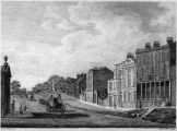
'South Entrance to Doncaster' / Miller, Edward. The History and Antiquities of Doncaster and its Vicinity, with Anecdotes of Eminent Men (Doncaster; London, [1804]); plate facing p. 1; engr. by Edward Shirt from painting by Frederick Nash.
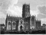
'Doncaster Church' / Miller, Edward. The History and Antiquities of Doncaster and its Vicinity, with Anecdotes of Eminent Men (Doncaster; London, [1804]); plate facing p. 71; engr. by B. Howlett from painting by Frederick Nash.
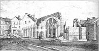
The ruins of the Church of St Mary Magdalen, Doncaster, on demolition in 1846. / Wikipedia: Doncaster.
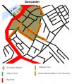
Medieval Doncaster / Adapted from map at Wikipedia: Doncaster.


