
Robin Hood Court (Milton Street): Difference between revisions
m (Text replacement - "PnItemNav" to "PlaceNamesItemNavigation") |
m (Text replacement - "PnItemAlsoSee" to "PlaceNamesItemAlsoSee") |
||
| Line 44: | Line 44: | ||
<!--== Brief mention == | <!--== Brief mention == | ||
* --> | * --> | ||
{{ | {{PlaceNamesItemAlsoSee}} | ||
== Notes == | == Notes == | ||
Revision as of 00:40, 6 January 2021
| Locality | |
|---|---|
| Coordinate | 51.520226, -0.091278 |
| Adm. div. | Middlesex, now Greater London |
| Vicinity | W side of Milton Street, c. 40 m N of Silk Street; formerly Grub Street |
| Type | Thoroughfare |
| Interest | Robin Hood name |
| Status | Defunct |
| First Record | 1682 |
| A.k.a. | Robin Hood's court; Robin hood's court; Robinhood Court |


By Henrik Thiil Nielsen, 2018-06-26. Revised by Henrik Thiil Nielsen, 2021-01-06.
Robin Hood Court was located in the area immediately north of Silk Street and west of Milton Street, where now a large law firm has its headquarters.
John Strype in 1720 (see Allusions below) mentions 'Haberdashers Square, very genteel, with new well built Houses. The Court is square, and inclosed in with Palisade Pales, except a handsome passage to the Houses round about; and in the midst is a Dial', adding that '[t]his Court was made out of two old ones, viz. Paviers Court, and Robin Hood Court'. Haberdashers' Square was situated a few tens of meters west of the long vanished Grub Street from which it was reached via a short alley that looks relatively narrow on John Rocque's 1746 map of London and Westminster (see map detail below). The point where this alley led west from Grub street seems to be very close to the entrance to the underground parking lot of the law firm. Henry Harben's earliest reference to Robin Hood Court is Ogilby and Morgan's Large and Accurate Map of the City of London (1677), but scans of this map available on the web (see Maps section below) do not include the name of the street.[1] The earliest occurrence IRHB can verify is that in William Morgan's 1682 map of London, where it figures as 'Robinhood Court'.[2] Strype makes it clear that Robin Hood Court was already (recent) history when he wrote in 1720. Robin Hood Court is listed in several 18th century directories and address lists (see Gazetteers below), While one can of course not rule out the possibility that the name lingered after the court was gone, it seems most likely that the name simply lived on in the directories through uncritical borrowing from earlier compilations. Lockie's Topography (editions of 1810 and 1813) was based on first-hand knowledge, and it does not include this particular Robin Hood Court. Template:PlaceNamesItemQuery
Gazetteers
- Dobson, R. B., ed.; Taylor, J., ed. Rymes of Robyn Hood: an Introduction to the English Outlaw (London, 1976), p. 299, s.n. Robin Hood Court [2].
Sources
- Anonymous. A New Review of London: being an Exact Survey, lately taken, of every Street, Lane, Court, Alley, Square, Close, Green, Wharf, Row, Garden, Field, and aLl Places, by what Name soever call'd, within the Cities, Liberties, or Suburbs of London, Westminster, and the Borough of Southwark. 3rd ed. (London, 1728), p. 30, s.n. Robin hood's court
- Anonymous. The Compleat Compting-House Companion: or, Young Merchant, or Tradesman's Sure Guide (London, 1763), p. 417, s.n. Robin Hood court [3]
- Anonymous, compil. The New Complete Guide to all Persons who have any Trade or Concern with the City of London, and Parts adjacent ([s.l], 1783), p. 59 s.n. Robin Hood's court [3]
- Company of Parish-Clerks, The, compil. New Remarks of London: Or, A Survey of the Cities of London and Westminster, of Southwark, and Part of Middlesex and Surrey, Within the Circumference of the Bills of Mortality. Containing the Situation, Antiquity and Rebuilding of Each Church, the Value of the Rectory or Vicarage; in Whose Gifts They are; and the Names of the Present Incumbents and Lecturers. Of the Several Vestries, the Hours of Prayer, Parish and Ward Officers, Charity and other Schools; the Number of Charity-children, How Maintained, Educated and Placed out Apprentices, or Put to Service. Of the Alms-houses, Work-houses and Hospitals. The Remarkable Places and Things in Each Parish, with the Limits or Bounds, Streets, Lanes, Courts, and Number of Houses. Likewise an Alphabetical Table of All the Streets, Courts, Lanes, Alleys, Yards, Rows, Rents, Squares, &c. Within the Bills of Mortality, Shewing in What Liberty or Freedom They are, and an Easy Method for Finding any of them. Of the Several Inns of Courts, and Inns of Chancery, with Their Several Buildings, Courts, Lanes, &c. Collected by the Company of Parish-Clerks. To which are added, The Places to which Penny Post Letters are Sent, with Proper Directions Therein. The Wharfs, Keys, Docks, &c. near the River Thames. Of Water-carriage to Several Cities, Towns, &c. The Rates of Water Men, Porters of All Kinds, and Car Men. To What Inns Stage-coaches, Flying-coaches, Waggons and Carriers Come, and the Days They Go out. The Whole being very Useful for Ladies, Gentlemen, Clergymen, Merchants, Tradesmen, Coach-men, Chair-men, Car-men, Porters, Bailiffs, and Others (London, 1732), p. 361 s.n. Robin hood's court
- Harben, Henry A., compil.; [Greaves, I.I., ed.]. A Dictionary of London: Being Notes Topographical and Historical Relating to the Streets and Principal Buildings in the City of London (London, 1918), pp. 285 s.n. Haberdashers' Square, 505 s.n. Robinhood Court [1].
Maps
- Ogilby, John, cartog.; Morgan, William, cartog. Large and Accurate Map of the City of London ([s.l.], [1677])
- Morgan, Wm., cartog.; Morden, Robt., cartog.; Lea, Phil., cartog. London &c. Actually Survey'd [and] A Prospect of London and Westminster Taken at Several Stations to the Southward thereof ([s.l.], [1682]); see next
- Morgan, Wm., cartog.; Morden, Robt., cartog.; Lea, Phil., cartog. London &c. Actually Survey'd [and] A Prospect of London and Westminster Taken at Several Stations to the Southward thereof (London, 1904), No. 522 in the list of 'Referenees [sic] in London[,] Continued from No.330 [sic] and ending at No. 952 King Johns Court. [sic] in shoreditch': 'Robinhood Court'
- Rocque, John, cartog.; Pine, John, engr. A Plan of the Cities of London and Westminster, and Borough of Southwark (London, 1746)
- 25" O.S. map London (1915- Numbered sheets) V.11 (1916; rev. 1914)
- 25" O.S. map London (1915- Numbered sheets) V.11 (1916; rev. 1914) (georeferenced)
- 6" O.S. map Middlesex XVII (1880-82; surveyed 1868-73)
- 6" O.S. map Surrey III (1880; surveyed 1868-73)
- 6" O.S. map London VII.SE (1894-96; rev. 1893-94)
- 6" O.S. map Surrey III.NW (1898; rev. 1893-95)
- 6" O.S. map Surrey III.NW (1898; rev. 1893-95) (georeferenced)
- 6" O.S. map London Sheet K (1920; rev. 1913-14)
- 6" O.S. map London Sheet K (c. 1946; rev. 1938).
Also see
Notes
- ↑ Harben, Henry A., compil.; [Greaves, I.I., ed.]. A Dictionary of London: Being Notes Topographical and Historical Relating to the Streets and Principal Buildings in the City of London (London, 1918), pp. 285 s.n. Haberdashers' Square, 505 s.n. Robinhood Court [1]; Dobson, R. B., ed.; Taylor, J., ed. Rymes of Robyn Hood: an Introduction to the English Outlaw (London, 1976), p. 299, s.n. Robin Hood Court [2].
- ↑ Morgan, Wm., cartog.; Morden, Robt., cartog.; Lea, Phil., cartog. London &c. Actually Survey'd [and] A Prospect of London and Westminster Taken at Several Stations to the Southward thereof (London, 1904), No. 522 in the list of 'Referenees [sic] in London[,] Continued from No.330 [sic] and ending at No. 952 King Johns Court. [sic] in shoreditch': 'Robinhood Court'.
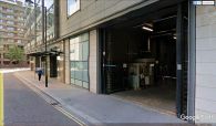
The Robin Hood Court at this site was recent history in 1720 / Google Earth Street View.

The Google Street View photo car peeps into the site of Robin Hood Court / Google Earth Street View.
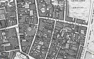
John Rocque's map of London and Westminster (1746), centred on 'Haberdashers Square', which according to John Strype (1720) 'was made out of two old ones, viz. Paviers Court, and Robin Hood Court' / Locating London's Past.
