
Robin Hood's Well (Higham): Difference between revisions
m (→Maps) |
m (Text replacement - "ImgGalleryIntro" to "ImageGalleryIntroduction") |
||
| (15 intermediate revisions by 2 users not shown) | |||
| Line 1: | Line 1: | ||
__NOTOC__{{ | __NOTOC__{{PlaceNamesItemTop|Lat=53.81239|Lon=-2.27858|AdministrativeDivision=Lancashire|Vicinity=''c.'' 20 m NW of the Calder, near Higham/Ightenhill Bridge; SE of Pendle Hall Farm|Type=Natural feature|Interest=Robin Hood name| | ||
Status=Defunct|Demonym=|Riding=|GreaterLondon=|Year=1926|Aka=|Century=|Cluster1=|Cluster2=|Cluster3=|Image=geograph-4085505-by-Chris-Heaton.jpg|Postcards=|ExtraCat1=|ExtraCat2=|ExtraCat3=|ExtraCat4=|ExtraCat5=|ExtraLink1=|ExtraLink2=|ExtraLink3=|ExtraLink4=|ExtraLink5=|ExtraLinkName1=|ExtraLinkName2=|ExtraLinkName3=|ExtraLinkName4=|ExtraLinkName5=|GeopointPrefix=|GeopointSuffix=|VicinitySuffix=|StatusSuffix=|DatePrefix=|DateSuffix=}} | Status=Defunct|Demonym=|Riding=|GreaterLondon=|Year=1926|Aka=|Century=|Cluster1=|Cluster2=|Cluster3=|Image=geograph-4085505-by-Chris-Heaton.jpg|Postcards=|ExtraCat1=|ExtraCat2=|ExtraCat3=|ExtraCat4=|ExtraCat5=|ExtraLink1=|ExtraLink2=|ExtraLink3=|ExtraLink4=|ExtraLink5=|ExtraLinkName1=|ExtraLinkName2=|ExtraLinkName3=|ExtraLinkName4=|ExtraLinkName5=|GeopointPrefix=|GeopointSuffix=|VicinitySuffix=|StatusSuffix=|DatePrefix=|DateSuffix=}} | ||
{{#display_map:{{#var:Coords}}~{{#replace:{{PAGENAME}}|'|'}}|width=34% | {{#display_map:{{#var:Coords}}~{{#replace:{{PAGENAME}}|'|'}}|width=34%|enablefullscreen=yes}}<div class="pnMapLegend">Site of Robin Hood's Well, Higham.</div> | ||
[[File:{{#var: | [[File:{{#var:Image}}|thumb|right|500px|Ford over the River Calder, near the site of Robin Hood's Well / [https://www.geograph.org.uk/photo/4085505 Chris Heaton, 20 Jul. 2014, Creative Commons, via Geograph.]]]<div class="no-img"> | ||
<p id="byline">By Henrik Thiil Nielsen, 2019-02-23. Revised by {{#realname:{{REVISIONUSER}}}}, {{REVISIONYEAR}}-{{REVISIONMONTH}}-{{REVISIONDAY2}}.</p | <p id="byline">By Henrik Thiil Nielsen, 2019-02-23. Revised by {{#realname:{{REVISIONUSER}}}}, {{REVISIONYEAR}}-{{REVISIONMONTH}}-{{REVISIONDAY2}}.</p> | ||
There was formerly a Robin Hood's Well a few meters north of the Calder, just south of the present Pendle Hall Farm. | There was formerly a Robin Hood's Well a few meters north of the Calder, just south of the present Pendle Hall Farm. | ||
The well is mentioned twice in a local ramblers' guide published in 1926 (see Allusions below). There is still a spring there, but its water no longer flows to the surface as the water is being pumped to some nearby locality, perhaps for use at Pendle Hall Farm or as water supply for sheep. A mere trickle flows from the area near the pump to the river. The well water was believed to be efficatious against certain ailments of the eye.<ref>[https://megalithix.wordpress.com/2017/09/17/robin-hoods-well-higham/ The Northern Antiquarian: Robin Hood’s Well, Higham, Lancashire.]</ref> An unnamed well is indicated in some of the O.S. maps listed below. | The well is mentioned twice in a local ramblers' guide published in 1926 (see Allusions below). There is still a spring there, but its water no longer flows to the surface as the water is being pumped to some nearby locality, perhaps for use at Pendle Hall Farm or as water supply for sheep. A mere trickle flows from the area near the pump to the river. The well water was believed to be efficatious against certain ailments of the eye.<ref>[https://megalithix.wordpress.com/2017/09/17/robin-hoods-well-higham/ The Northern Antiquarian: Robin Hood’s Well, Higham, Lancashire.]</ref> An unnamed well is indicated in some of the O.S. maps listed below. | ||
{{ | {{PlaceNamesItemAllusionsAndRecords}} | ||
== Gazetteers == | == Gazetteers == | ||
* Not included in {{:Dobson, Richard Barrie 1976a}}, pp. 293-311. | * Not included in {{:Dobson, Richard Barrie 1976a}}, pp. 293-311. | ||
| Line 27: | Line 27: | ||
<!--== Background == | <!--== Background == | ||
* --> | * --> | ||
== Brief mention == | == Brief mention == | ||
* [https://megalithix.wordpress.com/sites/holy-wells/ Northern Antiquarian: Holy Wells, Healing Springs & Spas.] | * [https://megalithix.wordpress.com/sites/holy-wells/ Northern Antiquarian: Holy Wells, Healing Springs & Spas.] | ||
{{ | {{PlaceNamesItemAlsoSee}} | ||
== Notes == | == Notes == | ||
<references/> | <references/> | ||
</div> | |||
<div id="gallery"> | |||
< | {{ImageGalleryIntroduction}} | ||
{{ | |||
<gallery widths="195px"> | <gallery widths="195px"> | ||
geograph-4085505-by-Chris-Heaton.jpg|Ford over the River Calder, near the Higham/Ightenhill Bridge and the site of Robin Hood's Well / [https://www.geograph.org.uk/photo/4085505 Chris Heaton, 20 Jul. 2014, Creative Commons, via Geograph.] | geograph-4085505-by-Chris-Heaton.jpg|Ford over the River Calder, near the Higham/Ightenhill Bridge and the site of Robin Hood's Well / [https://www.geograph.org.uk/photo/4085505 Chris Heaton, 20 Jul. 2014, Creative Commons, via Geograph.] | ||
river-calder-stepping-stones.jpg|Stepping stones on River Calder, near the site of Robin Hood's Well / [https://www.google.dk/maps/@53.8117814,-2.278791,3a,75y,90t/data=!3m8!1e2!3m6!1sAF1QipNeZ6qwmcCNEUUvw8FbIZQ_cvg2axSw0wRv_jFO!2e10!3e12!6shttps:%2F%2Flh5.googleusercontent.com%2Fp%2FAF1QipNeZ6qwmcCNEUUvw8FbIZQ_cvg2axSw0wRv_jFO%3Dw203-h129-k-no!7i1400!8i895?hl=en Google Maps] | river-calder-stepping-stones.jpg|Stepping stones on River Calder, near the site of Robin Hood's Well / [https://www.google.dk/maps/@53.8117814,-2.278791,3a,75y,90t/data=!3m8!1e2!3m6!1sAF1QipNeZ6qwmcCNEUUvw8FbIZQ_cvg2axSw0wRv_jFO!2e10!3e12!6shttps:%2F%2Flh5.googleusercontent.com%2Fp%2FAF1QipNeZ6qwmcCNEUUvw8FbIZQ_cvg2axSw0wRv_jFO%3Dw203-h129-k-no!7i1400!8i895?hl=en Google Maps] | ||
</gallery> | </gallery> | ||
</div> | |||
{{PlaceNamesItemNavigation}} | |||
{{ | |||
Latest revision as of 13:51, 7 January 2021
| Locality | |
|---|---|
| Coordinate | 53.81239, -2.27858 |
| Adm. div. | Lancashire |
| Vicinity | c. 20 m NW of the Calder, near Higham/Ightenhill Bridge; SE of Pendle Hall Farm |
| Type | Natural feature |
| Interest | Robin Hood name |
| Status | Defunct |
| First Record | 1926 |

By Henrik Thiil Nielsen, 2019-02-23. Revised by Henrik Thiil Nielsen, 2021-01-07.
There was formerly a Robin Hood's Well a few meters north of the Calder, just south of the present Pendle Hall Farm.
The well is mentioned twice in a local ramblers' guide published in 1926 (see Allusions below). There is still a spring there, but its water no longer flows to the surface as the water is being pumped to some nearby locality, perhaps for use at Pendle Hall Farm or as water supply for sheep. A mere trickle flows from the area near the pump to the river. The well water was believed to be efficatious against certain ailments of the eye.[1] An unnamed well is indicated in some of the O.S. maps listed below.
Allusions
1926 - Bates, Joe - Rambles twix Pendle and Holme (2)
A few yards from the river [Calder] is a thorn hedge which divides the Shuttleworth and Starkie estates. A bridge now spans the river at this point. Across the way down stream leads to Padiham, up bank to Higham, and against the stream to Brierfield. The riparian rights are claimed by the Starkies of Huntroyd. [p. 35:]
In the bank under "Eleven Trees" is a spring of icy cold water. It used to be called Robin Hood's well. This water was at one time considered a specific for certain ailments of the eyes.[2]
1926 - Bates, Joe - Rambles twix Pendle and Holme (3)
The view down stream takes in Hunter's Oak Farm, Hag Wood, the Stepping Stones, Gawthorpe Hall and Woods and Cornfield Pit, which makes up a charming pastoral composition.
The green knoll on the right used to be decked with a cluster of eleven trees, and was long known by the abbreviated term of "'Leven Trees."
This spring of icy-cold water is one of the many Robin Hood's wells.
Here is the new bridge. Across is the road leading up to Ighten Hill and Padiham Road, and at this historic place ramblers from the Trafalgar Road, Gannow, and Padiham Road districts may join in the ramble. The path along the river side leads direct to Padiham.[3]
Gazetteers
- Not included in Dobson, R. B., ed.; Taylor, J., ed. Rymes of Robyn Hood: an Introduction to the English Outlaw (London, 1976), pp. 293-311.
Sources
Maps
- 25" O.S. map Lancashire LVI.13 (1893; surveyed 1890-91)
- 25" O.S. map Lancashire LVI.13 (1912; rev. 1910) (georeferenced)
- 25" O.S. map Lancashire LVI.13 (1912; rev. 1910)
- 25" O.S. map Lancashire LVI.13 (1932; rev. 1930)
- 6" O.S. map Lancashire LVI (1848; surveyed 1844)
- 6" O.S. map Lancashire LVI.SW (1895; surveyed 1890-91)
- 6" O.S. map Lancashire LVI.SW (1914; rev. 1909-10) (georeferenced)
- 6" O.S. map Lancashire LVI.SW (1914; rev. 1909-10)
- 6" O.S. map Lancashire LVI.SW (1933; rev. 1929)
- 6" O.S. map Lancashire LVI.SW (1947; rev. 1938).
Brief mention
Notes
Image gallery
Click any image to display it in the lightbox, where you can navigate between images by clicking in the right or left side of the current image.
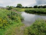
Ford over the River Calder, near the Higham/Ightenhill Bridge and the site of Robin Hood's Well / Chris Heaton, 20 Jul. 2014, Creative Commons, via Geograph.
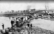
Stepping stones on River Calder, near the site of Robin Hood's Well / Google Maps
