
Robin Hood's Cave (Kirkby in Ashfield): Difference between revisions
m (Text replacement - "{{#display_map:{{#var:Coords}}|" to "{{#display_map:{{#var:Coords}}~{{PAGENAME}}|") |
m (Text replacement - "irhb.org/wiki/" to "irhb.org/w/") |
||
| (37 intermediate revisions by the same user not shown) | |||
| Line 1: | Line 1: | ||
__NOTOC__{{ | __NOTOC__{{PlaceNamesItemTop|Lat=53.0844|Lon=-1.2400|AdministrativeDivision=Nottinghamshire|Vicinity=1.5 km SSE of central Kirkby in Ashfield|Type=Natural feature|Interest=Robin Hood name|Status=Extant|Demonym=|Riding=|GreaterLondon=|Year=1825|Aka=|Century=|Cluster1=Kirkby in Ashfield|Cluster2=|Cluster3=|Image=robin-hoods-cave-annesley-rich-CROPPED.jpg|Postcards=|ExtraCat1=Places named Robin Hood's Cave|ExtraCat2=|ExtraCat3=|ExtraCat4=|ExtraCat5=|ExtraLink1=Robin Hood's Hills (Kirkby in Ashfield)|ExtraLink2=Robin Hood's Chair (Kirkby in Ashfield)|ExtraLink3=Friar Tuck's Well (Blidworth)|ExtraLink4=|ExtraLink5=|ExtraLinkName1=|ExtraLinkName2=|ExtraLinkName3=|ExtraLinkName4=|ExtraLinkName5=|GeopointPrefix=|GeopointSuffix=|StatusSuffix=|DatePrefix=''c. ''|DateSuffix=}} | ||
{{#display_map:{{#var:Coords}}~{{PAGENAME}}|width=34%}}<div class="pnMapLegend">Robin Hood's Chair.</div> | {{#display_map:{{#var:Coords}}~{{#replace:{{PAGENAME}}|'|'}}|width=34%|enablefullscreen=yes}}<div class="pnMapLegend">Robin Hood's Chair.</div> | ||
[[File:rob_howl_robin_hoods_cave_kirkby_in_ashfield.jpg|thumb|right|500px|Robin Hood's Cave is hidden somewhere under the bracken | <!--[[File:rob_howl_robin_hoods_cave_kirkby_in_ashfield.jpg|thumb|right|500px|Robin Hood's Cave is hidden somewhere under the bracken / [https://www.irhb.org/w/index.php/File:Panoramio_rob_howl_robin_hoods_cave_kirkby_in_ashfield.zip Rob Howl, via Panoramio – no longer online.]]]--> | ||
[[File:{{#var:Image}}|thumb|right|500px|Robin Hood's Cave is here in the darkest area among the bracken. Cropped photo / Courtesy Rich. Also see photos in gallery below.]] | |||
<div class="no-img"> | <div class="no-img"> | ||
<p id="byline">By Henrik Thiil Nielsen, 2016-10-04. Revised by {{#realname:{{REVISIONUSER}}}}, {{REVISIONYEAR}}-{{REVISIONMONTH}}-{{REVISIONDAY2}}. Photos and information courtesy Rich.</p> | |||
Now filled in and hidden to the casual passer-by, Robin Hood's Cave sits near a path immediately east of Derby Road, some 1.5 km SSE of central Kirkby in Ashfield. About 700 m NE of the site of the cave are found [[Robin Hood's Hills (Kirkby in Ashfield)|Robin Hood's Hills]] and [[Robin Hood's Chair (Kirkby in Ashfield)|Robin Hood's Chair]], while the [[Robin Hood (Kirkby in Ashfield)|Robin Hood]], a public house, could once be frequented about 600 m S of the Cave, just south of Annesley at what was then a crossroads but is now the corner of Derby Road and Forest Road. The earliest source for this place-name would seem to be an O.S. map from ''c.'' 1825.<ref>{{:Gover, John Eric Bruce 1940a}}, pp. 64, 294.</ref> | |||
Thanks to the kindness of an IRHB visitor named Rich we now have several excellent photos of the cave and its surroundings. The cave is not easy to spot, but he found it on his second attempt. Here are his comments on each photo: | |||
<ol> | |||
<li>(IRHB's crop of photo No. 2. See next.)</li> | |||
<li>This photo 'shows the location of the cave, currently hiding in bracken'.</li> | |||
<li>This photo 'shows the cave as I first spotted it – my eye was drawn to the dark area behind the bracken in the middle of the photo.</li> | |||
<li>This photo 'shows the Robin Hood's Hills as you first see them from Shoulder of Mutton Hill in Annesley. The cave would be off to the right of the photo'.</li> | |||
<li>This photo 'shows the roof of the cave after I'd done a bit of excavation with the big stick at the bottom of the photo. It was filled with very loose sand which you could tell wasn't natural.</li> | |||
<li>This photo 'shows the roof of the cave again – it is difficult to tell from the photo but it went back and down for about a metre or a metre and a half.</li> | |||
</ol> | |||
Rich has also provided excellent photos of [[Robin Hood's Hills (Kirkby in Ashfield)|Robin Hood's Hills]] and [[Robin Hood's Chair (Kirkby in Ashfield)|Chair]] in Annesley (Kirkby in Ashfield). | |||
{{PlaceNamesItemAllusionsAndRecords}} | |||
== Gazetteers == | |||
* {{:Dobson, Richard Barrie 1976a}}, p. 302, ''s.n.'' 'Robin Hood's Cave' [II] and 'Robin Hood's Hills' | * {{:Dobson, Richard Barrie 1976a}}, p. 302, ''s.n.'' 'Robin Hood's Cave' [II] and 'Robin Hood's Hills' | ||
* {{:Gover, John Eric Bruce 1940a}}, pp. 64, 294. | * {{:Gover, John Eric Bruce 1940a}}, pp. 64, 294. | ||
=== | == Maps == | ||
* [http://maps.nls.uk/geo/explore/#zoom=18&lat=53.0850&lon=-1.2395&layers=168&b=5 25" O.S. map ''Nottinghamshire'' XXVII.15 (1900; rev. 1898)] (georeferenced) | |||
* [https://maps.nls.uk/view/115390811#zoom=4&lat=3465&lon=14811&layers=BT 25" O.S. map ''Nottinghamshire'' XXVII.15 (1879; surveyed 1877)] | |||
* [https://maps.nls.uk/view/115390814#zoom=5&lat=3466&lon=14203&layers=BT 25" O.S. map ''Nottinghamshire'' XXVII.15 (1900; rev. 1898)] | |||
* 25" O.S. map ''Nottinghamshire'' XXVII.15 (''c.'' 1917; rev. ''c.'' 1914). No copy in NLS | |||
* [https://maps.nls.uk/view/115390817#zoom=5&lat=3552&lon=14133&layers=BT 25" O.S. map ''Nottinghamshire'' XXVII.15 (1945; rev. 1938)] | |||
* [http://maps.nls.uk/view/101602755#zoom=5&lat=2409&lon=5171&layers=BT 6" O.S. map ''Nottinghamshire'' XXVII.SE (1886; surveyed 1877-78)] | * [http://maps.nls.uk/view/101602755#zoom=5&lat=2409&lon=5171&layers=BT 6" O.S. map ''Nottinghamshire'' XXVII.SE (1886; surveyed 1877-78)] | ||
* [http://maps.nls.uk/view/101602752#zoom=5&lat=2286&lon=4980&layers=BT 6" O.S. map ''Nottinghamshire'' XXVII.SE (1900; rev. 1898)] | * [http://maps.nls.uk/view/101602752#zoom=5&lat=2286&lon=4980&layers=BT 6" O.S. map ''Nottinghamshire'' XXVII.SE (1900; rev. 1898)] | ||
| Line 15: | Line 33: | ||
* [http://maps.nls.uk/view/101602749#zoom=4&lat=2608&lon=5282&layers=BT 6" O.S. map ''Nottinghamshire'' XXVII.SE (1921; rev. 1913-14)] | * [http://maps.nls.uk/view/101602749#zoom=4&lat=2608&lon=5282&layers=BT 6" O.S. map ''Nottinghamshire'' XXVII.SE (1921; rev. 1913-14)] | ||
* [http://maps.nls.uk/view/101602746#zoom=4&lat=2575&lon=5227&layers=BT 6" O.S. map ''Nottinghamshire'' XXVII.SE (''c.'' 1949; rev. 1938)] | * [http://maps.nls.uk/view/101602746#zoom=4&lat=2575&lon=5227&layers=BT 6" O.S. map ''Nottinghamshire'' XXVII.SE (''c.'' 1949; rev. 1938)] | ||
* [https://maps.nls.uk/view/102341364#zoom=5&lat=1728&lon=11446&layers=BT 6" O.S. map ''Derbyshire'' XXXVI (1921; rev. 1913-14).] | * [https://maps.nls.uk/view/102341364#zoom=5&lat=1728&lon=11446&layers=BT 6" O.S. map ''Derbyshire'' XXXVI (1921; rev. 1913-14).] | ||
== Background == | |||
* [http://www.panoramio.com/photo/81047478 Panoramio: In search of Robin Hood's Cave]. | * [http://www.panoramio.com/photo/81047478 Panoramio: In search of Robin Hood's Cave]. | ||
{{ | {{PlaceNamesItemAlsoSee}} | ||
== Notes == | |||
<references/> | <references/> | ||
</div> | |||
<div id="gallery"> | |||
{{ImageGalleryIntroduction}} | |||
<gallery widths="195px"> | |||
robin-hoods-cave-annesley-rich-CROPPED.jpg|Robin Hood's Cave is here in the darkest area among the bracken. Cropped photo / Courtesy Rich. | |||
robin-hoods-cave-annesley-rich.jpg|Preceding photo uncropped / Courtesy Rich. | |||
Annesley robin hoods hills rich.jpg|'Robin Hood's Hills as you first see them from Shoulder of Mutton Hill in Annesley. The cave would be off to the right of the photo' / Courtesy Rich. | |||
robin-hoods-cave-annesley-rich-2.jpg|This photo 'shows the location of the cave, currently hiding in bracken' / Courtesy Rich. | |||
robin-hoods-cave-annesley-rich-3.jpg|This photo 'shows the cave as I first spotted it – my eye was drawn to the dark area behind the bracken in the middle of the photo / Courtesy Rich. | |||
robin-hoods-cave-annesley-rich-4.jpg|The 'roof of the cave after I'd done a bit of excavation with the big stick at the bottom of the photo' / Courtesy Rich. | |||
</gallery> | |||
</div> | </div> | ||
{{ | {{PlaceNamesItemNavigation}} | ||
Latest revision as of 22:03, 10 June 2022
| Locality | |
|---|---|
| Coordinate | 53.0844, -1.24 |
| Adm. div. | Nottinghamshire |
| Vicinity | 1.5 km SSE of central Kirkby in Ashfield |
| Type | Natural feature |
| Interest | Robin Hood name |
| Status | Extant |
| First Record | c. 1825 |

By Henrik Thiil Nielsen, 2016-10-04. Revised by Henrik Thiil Nielsen, 2022-06-10. Photos and information courtesy Rich.
Now filled in and hidden to the casual passer-by, Robin Hood's Cave sits near a path immediately east of Derby Road, some 1.5 km SSE of central Kirkby in Ashfield. About 700 m NE of the site of the cave are found Robin Hood's Hills and Robin Hood's Chair, while the Robin Hood, a public house, could once be frequented about 600 m S of the Cave, just south of Annesley at what was then a crossroads but is now the corner of Derby Road and Forest Road. The earliest source for this place-name would seem to be an O.S. map from c. 1825.[1]
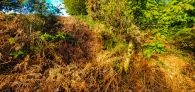
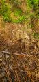
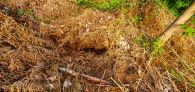
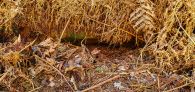
Thanks to the kindness of an IRHB visitor named Rich we now have several excellent photos of the cave and its surroundings. The cave is not easy to spot, but he found it on his second attempt. Here are his comments on each photo:
- (IRHB's crop of photo No. 2. See next.)
- This photo 'shows the location of the cave, currently hiding in bracken'.
- This photo 'shows the cave as I first spotted it – my eye was drawn to the dark area behind the bracken in the middle of the photo.
- This photo 'shows the Robin Hood's Hills as you first see them from Shoulder of Mutton Hill in Annesley. The cave would be off to the right of the photo'.
- This photo 'shows the roof of the cave after I'd done a bit of excavation with the big stick at the bottom of the photo. It was filled with very loose sand which you could tell wasn't natural.
- This photo 'shows the roof of the cave again – it is difficult to tell from the photo but it went back and down for about a metre or a metre and a half.
Rich has also provided excellent photos of Robin Hood's Hills and Chair in Annesley (Kirkby in Ashfield).
Gazetteers
- Dobson, R. B., ed.; Taylor, J., ed. Rymes of Robyn Hood: an Introduction to the English Outlaw (London, 1976), p. 302, s.n. 'Robin Hood's Cave' [II] and 'Robin Hood's Hills'
- Gover, J.E.B.; Mawer, Allen; Stenton, F.M. The Place-Names of Nottinghamshire (English Place-Name Society, vol. XVII) (Cambridge, 1940), pp. 64, 294.
Maps
- 25" O.S. map Nottinghamshire XXVII.15 (1900; rev. 1898) (georeferenced)
- 25" O.S. map Nottinghamshire XXVII.15 (1879; surveyed 1877)
- 25" O.S. map Nottinghamshire XXVII.15 (1900; rev. 1898)
- 25" O.S. map Nottinghamshire XXVII.15 (c. 1917; rev. c. 1914). No copy in NLS
- 25" O.S. map Nottinghamshire XXVII.15 (1945; rev. 1938)
- 6" O.S. map Nottinghamshire XXVII.SE (1886; surveyed 1877-78)
- 6" O.S. map Nottinghamshire XXVII.SE (1900; rev. 1898)
- 6" O.S. map Nottinghamshire XXVII.SE (1900; rev. 1898) (georeferenced)
- 6" O.S. map Nottinghamshire XXVII.SE (1921; rev. 1913-14)
- 6" O.S. map Nottinghamshire XXVII.SE (c. 1949; rev. 1938)
- 6" O.S. map Derbyshire XXXVI (1921; rev. 1913-14).
Background
Also see
- Kirkby in Ashfield place-name cluster
- Places named Robin Hood's Cave
- Robin Hood's Hills (Kirkby in Ashfield)
- Robin Hood's Chair (Kirkby in Ashfield)
- Friar Tuck's Well (Blidworth).
Notes
Image gallery
Click any image to display it in the lightbox, where you can navigate between images by clicking in the right or left side of the current image.
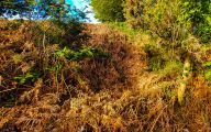
Robin Hood's Cave is here in the darkest area among the bracken. Cropped photo / Courtesy Rich.
Preceding photo uncropped / Courtesy Rich.
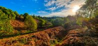
'Robin Hood's Hills as you first see them from Shoulder of Mutton Hill in Annesley. The cave would be off to the right of the photo' / Courtesy Rich.
This photo 'shows the location of the cave, currently hiding in bracken' / Courtesy Rich.
This photo 'shows the cave as I first spotted it – my eye was drawn to the dark area behind the bracken in the middle of the photo / Courtesy Rich.
The 'roof of the cave after I'd done a bit of excavation with the big stick at the bottom of the photo' / Courtesy Rich.


