Little John (Hardcastle Moor): Difference between revisions
m (Text replacement - "|service=leaflet}}" to "|service=leaflet|enablefullscreen=yes}}") |
m (Text replacement - "PlaceNamesItemQuery" to "PlaceNamesItemAllusionsAndRecords") |
||
| (12 intermediate revisions by the same user not shown) | |||
| Line 1: | Line 1: | ||
__NOTOC__{{ | __NOTOC__{{PlaceNamesItemTop|Lat=54.0839|Lon=-1.8399|AdministrativeDivision=Yorkshire|Vicinity=''c.'' 6 km W of Pateley Bridge|Type=Miscellaneous|Interest=Robin Hood name|Status=Defunct|Demonym=|Riding=West|GreaterLondon=|Year=1854|Aka=|Century=|Cluster1=|Cluster2=|Cluster3=|Image=geograph-564068-by-Mick-Borroff.jpg|Postcards=|ExtraCat1=Places named after Little John|ExtraCat2=Places named Robin Hood's Quarry|ExtraCat3=|ExtraCat4=|ExtraCat5=|GeopointPrefix=|GeopointSuffix=|StatusSuffix=?|DatePrefix=|DateSuffix=}} | ||
{{#display_map:{{#var:Coords}}~{{#replace:{{PAGENAME}}|'|'}}|width=34% | {{#display_map:{{#var:Coords}}~{{#replace:{{PAGENAME}}|'|'}}|width=34%|enablefullscreen=yes}}<div class="pnMapLegend">Little John, the quarry.</div> | ||
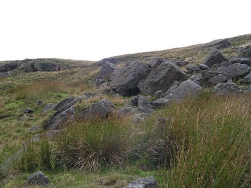
[[File:{{#var: | [[File:{{#var:Image}}|thumb|right|500px|Hollin Crags gritstone outcrop ''c.'' 200 m from the site of Little John / [https://www.geograph.org.uk/photo/564068 Mick Borroff, 23 Sep. 2007, Creative Commons, via Geograph.]]]<div class="no-img"> | ||
<p id="byline">By Henrik Thiil Nielsen, 2016-08-09. Revised by {{#realname:{{REVISIONUSER}}}}, {{REVISIONYEAR}}-{{REVISIONMONTH}}-{{REVISIONDAY2}}.</p> | <p id="byline">By Henrik Thiil Nielsen, 2016-08-09. Revised by {{#realname:{{REVISIONUSER}}}}, {{REVISIONYEAR}}-{{REVISIONMONTH}}-{{REVISIONDAY2}}.</p> | ||
The first 6" O.S. map of the Bewerley–Thornthwaite–Padside area, published in 1854, surveyed 1849-50, has the name "Little John" next to what must be the marker for a quarry,<ref>[http://maps.nls.uk/view/102344653#zoom=5&lat=7728&lon=5236&layers=BT 6" O.S. map ''Yorkshire'' 135 (1854, surveyed 1849-50)]; for the marker see [http://www.ancestry-maps.com/page-legend.asp Cassini Historical Maps: Keys and Legends.]</ref> on Hardcastle Moor, towards the SE end of the present Yorkshire Dales National Park. The quarry was situated immediately east of a footpath, not shown on Google Maps, but then running approximately NNW to SSE through the area. The quarry is not indicated on the later 6" O.S. maps.<ref>See maps section below.</ref> It is uncertain if the name had anything to do with Robin Hood's second-in-command; in the immediate vicinity was a quarry named Little Betty. | The first 6" O.S. map of the Bewerley–Thornthwaite–Padside area, published in 1854, surveyed 1849-50, has the name "Little John" next to what must be the marker for a quarry,<ref>[http://maps.nls.uk/view/102344653#zoom=5&lat=7728&lon=5236&layers=BT 6" O.S. map ''Yorkshire'' 135 (1854, surveyed 1849-50)]; for the marker see [http://www.ancestry-maps.com/page-legend.asp Cassini Historical Maps: Keys and Legends.]</ref> on Hardcastle Moor, towards the SE end of the present Yorkshire Dales National Park. The quarry was situated immediately east of a footpath, not shown on Google Maps, but then running approximately NNW to SSE through the area. The quarry is not indicated on the later 6" O.S. maps.<ref>See maps section below.</ref> It is uncertain if the name had anything to do with Robin Hood's second-in-command; in the immediate vicinity was a quarry named Little Betty. | ||
This part of Yorkshire then belonged to the West Riding but is now part of the North Riding. A search for "Little John" and "Hardcastle Moor" on 9 August 2016 yielded no relevant results.{{ | This part of Yorkshire then belonged to the West Riding but is now part of the North Riding. A search for "Little John" and "Hardcastle Moor" on 9 August 2016 yielded no relevant results.{{PlaceNamesItemAllusionsAndRecords}} | ||
== Gazetteers == | == Gazetteers == | ||
* Not included in {{:Dobson, Richard Barrie 1976a}}, pp. 293-311. | * Not included in {{:Dobson, Richard Barrie 1976a}}, pp. 293-311. | ||
| Line 15: | Line 14: | ||
* [http://maps.nls.uk/view/100944761#zoom=4&lat=4715&lon=4729&layers=BT 6" O.S. map ''Yorkshire'' CXXXV.NW (1910, rev. 1907)] | * [http://maps.nls.uk/view/100944761#zoom=4&lat=4715&lon=4729&layers=BT 6" O.S. map ''Yorkshire'' CXXXV.NW (1910, rev. 1907)] | ||
* [http://maps.nls.uk/view/100944761#zoom=4&lat=4715&lon=4729&layers=BT 6" O.S. map ''Yorkshire'' CXXXV.NW (1910, rev. 1907).] | * [http://maps.nls.uk/view/100944761#zoom=4&lat=4715&lon=4729&layers=BT 6" O.S. map ''Yorkshire'' CXXXV.NW (1910, rev. 1907).] | ||
{{ | {{PlaceNamesItemAlsoSee}} | ||
== Notes == | == Notes == | ||
<references/> | <references/> | ||
| Line 23: | Line 22: | ||
{{ | {{PlaceNamesItemNavigation}} | ||
Latest revision as of 00:51, 6 January 2021
| Locality | |
|---|---|
| Coordinate | 54.0839, -1.8399 |
| Adm. div. | West Riding of Yorkshire |
| Vicinity | c. 6 km W of Pateley Bridge |
| Type | Miscellaneous |
| Interest | Robin Hood name |
| Status | Defunct? |
| First Record | 1854 |

By Henrik Thiil Nielsen, 2016-08-09. Revised by Henrik Thiil Nielsen, 2021-01-06.
The first 6" O.S. map of the Bewerley–Thornthwaite–Padside area, published in 1854, surveyed 1849-50, has the name "Little John" next to what must be the marker for a quarry,[1] on Hardcastle Moor, towards the SE end of the present Yorkshire Dales National Park. The quarry was situated immediately east of a footpath, not shown on Google Maps, but then running approximately NNW to SSE through the area. The quarry is not indicated on the later 6" O.S. maps.[2] It is uncertain if the name had anything to do with Robin Hood's second-in-command; in the immediate vicinity was a quarry named Little Betty.
This part of Yorkshire then belonged to the West Riding but is now part of the North Riding. A search for "Little John" and "Hardcastle Moor" on 9 August 2016 yielded no relevant results.
Gazetteers
- Not included in Dobson, R. B., ed.; Taylor, J., ed. Rymes of Robyn Hood: an Introduction to the English Outlaw (London, 1976), pp. 293-311.
Maps
- 6" O.S. map Yorkshire 135 (1854, surveyed 1849-50)
- 6" O.S. map Yorkshire CXXXV (1895, rev. 1889-90)
- 6" O.S. map Yorkshire CXXXV.NW (1910, rev. 1907)
- 6" O.S. map Yorkshire CXXXV.NW (1910, rev. 1907).
Also see
Notes
- ↑ 6" O.S. map Yorkshire 135 (1854, surveyed 1849-50); for the marker see Cassini Historical Maps: Keys and Legends.
- ↑ See maps section below.
