Little John (Dronfield Church): Difference between revisions
From International Robin Hood Bibliography
mNo edit summary |
m (Text replacement - "PlaceNamesItemQuery" to "PlaceNamesItemAllusionsAndRecords") |
||
| (37 intermediate revisions by the same user not shown) | |||
| Line 1: | Line 1: | ||
__NOTOC__ | __NOTOC__{{PlaceNamesItemTop|Lat=53.301561|Lon=-1.472258|AdministrativeDivision=Derbyshire|Vicinity=Dronfield|Type=Miscellaneous|Interest=Robin Hood name|Status=Defunct|Demonym=|Riding=|GreaterLondon=|Year=1888|Aka=|Century=|Cluster1=|Cluster2=|Cluster3=|Image=St John the Baptist Dronfield 3.jpg|Postcards=|ExtraCat1=Places named after Little John|ExtraCat2=|ExtraCat3=|ExtraCat4=|ExtraCat5=|ExtraLink1=|ExtraLink2=|ExtraLink3=|ExtraLink4=|ExtraLink5=|ExtraLinkName1=|ExtraLinkName2=|ExtraLinkName3=|ExtraLinkName4=|ExtraLinkName5=|GeopointPrefix=|GeopointSuffix=|StatusSuffix=?|DatePrefix=|DateSuffix=}} | ||
{{ | {{#display_map:{{#var:Coords}}~{{#replace:{{PAGENAME}}|'|'}}|width=34%|enablefullscreen=yes}}<div class="pnMapLegend">St John the Baptist Church, Dronfield.</div> | ||
[[File:St John the Baptist Dronfield 3.jpg|500px|thumb|right|St John the Baptist, Dronfield / [http://www.flickr.com/people/35977634@N00 Liz Jones, Sheffield].]]<div class="no-img"> | |||
<p id="byline">By Henrik Thiil Nielsen, 2013-07-13. Revised by {{#realname:{{REVISIONUSER}}}}, {{REVISIONYEAR}}-{{REVISIONMONTH}}-{{REVISIONDAY2}}.</p> | |||
According to S.O. Addy (1888),<ref>{{:Addy, Sidney Oldall 1888a}}, pp. 16, s.n. 'Bidding Bell'; 136, s.n. 'Little John'; 260, s.n. 'ting-tang'.</ref> Little John was the name of a small bell in Dronfield parish church (St John the Baptist Church, Dronfield with Holmefield Parish). It was rung before service and after the peal was finished. Other names for it were Ting Tang or the Bidding Bell.{{PlaceNamesItemAllusionsAndRecords}} | |||
{{# | |||
[[File:St John the Baptist Dronfield 3.jpg|500px|thumb|right|St John the Baptist, Dronfield | |||
<p id="byline">By Henrik Thiil Nielsen, 2013-07-13. Revised by {{#realname:{{REVISIONUSER}}}}, {{REVISIONYEAR}}-{{REVISIONMONTH}}-{{REVISIONDAY2}}.</p | |||
According to S.O. Addy (1888),<ref>{{:Addy, Sidney Oldall 1888a}}, pp. 16, s.n. 'Bidding Bell'; 136, s.n. 'Little John'; 260, s.n. 'ting-tang'.</ref> Little John was the name of a small bell in Dronfield parish church (St John the Baptist Church, Dronfield with Holmefield Parish). It was rung before service and after the peal was finished. Other names for it were Ting Tang or the Bidding Bell. | |||
=== Sources | == Gazetteers == | ||
* Not included in {{:Dobson, Richard Barrie 1976a}}, pp. 293-311. | |||
== Sources == | |||
* {{:Addy, Sidney Oldall 1888a}}, pp. 16, s.n. 'Bidding Bell'; 136, s.n. 'Little John'; 260, s.n. 'ting-tang'. | * {{:Addy, Sidney Oldall 1888a}}, pp. 16, s.n. 'Bidding Bell'; 136, s.n. 'Little John'; 260, s.n. 'ting-tang'. | ||
== Maps == | |||
Dronfield Church indicated on these maps. | Dronfield Church indicated on these maps. | ||
* [http://maps.nls.uk/view/101600421#zoom=5&lat=4356&lon=2744&layers=BT 6" O.S. map ''Derbyshire'' XVIII.NW (1883; surveyed 1875-76)] | * [http://maps.nls.uk/view/101600421#zoom=5&lat=4356&lon=2744&layers=BT 6" O.S. map ''Derbyshire'' XVIII.NW (1883; surveyed 1875-76)] | ||
* [http://maps.nls.uk/view/102341313#zoom=5&lat=9048&lon=2304&layers=BT 6" O.S. map ''Derbyshire'' XVIII (1921; rev. 1914-15)] | * [http://maps.nls.uk/view/102341313#zoom=5&lat=9048&lon=2304&layers=BT 6" O.S. map ''Derbyshire'' XVIII (1921; rev. 1914-15)] | ||
* [http://maps.nls.uk/view/101600418#zoom=5&lat=3739&lon=3335&layers=BT 6" O.S. map ''Derbyshire'' XVIII.NW (1899; rev. 1897)] | * [http://maps.nls.uk/view/101600418#zoom=5&lat=3739&lon=3335&layers=BT 6" O.S. map ''Derbyshire'' XVIII.NW (1899; rev. 1897)] | ||
| Line 34: | Line 19: | ||
* [http://maps.nls.uk/view/101600412#zoom=4&lat=4278&lon=2598&layers=BT 6" O.S. map ''Derbyshire'' XVIII.NW (''c.'' 1946; rev. 1938)] | * [http://maps.nls.uk/view/101600412#zoom=4&lat=4278&lon=2598&layers=BT 6" O.S. map ''Derbyshire'' XVIII.NW (''c.'' 1946; rev. 1938)] | ||
* [http://maps.nls.uk/view/101600409#zoom=5&lat=4527&lon=2610&layers=BT 6" O.S. map ''Derbyshire'' XVIII.NW (''c.'' 1950; rev. 1945)] | * [http://maps.nls.uk/view/101600409#zoom=5&lat=4527&lon=2610&layers=BT 6" O.S. map ''Derbyshire'' XVIII.NW (''c.'' 1950; rev. 1945)] | ||
* [http://maps.nls.uk/view/101167586#zoom=6&lat=3585&lon=4920&layers=BT 1" O.S. Sheet 100; 3rd ed. (1909).] | |||
{{PlaceNamesItemAlsoSee}} | |||
== Notes == | |||
<references/> | <references/> | ||
</div> | </div> | ||
{{ | {{PlaceNamesItemNavigation}} | ||
Latest revision as of 00:50, 6 January 2021
| Locality | |
|---|---|
| Coordinate | 53.301561, -1.472258 |
| Adm. div. | Derbyshire |
| Vicinity | Dronfield |
| Type | Miscellaneous |
| Interest | Robin Hood name |
| Status | Defunct? |
| First Record | 1888 |
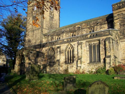
St John the Baptist Church, Dronfield.

St John the Baptist, Dronfield / Liz Jones, Sheffield.
By Henrik Thiil Nielsen, 2013-07-13. Revised by Henrik Thiil Nielsen, 2021-01-06.
According to S.O. Addy (1888),[1] Little John was the name of a small bell in Dronfield parish church (St John the Baptist Church, Dronfield with Holmefield Parish). It was rung before service and after the peal was finished. Other names for it were Ting Tang or the Bidding Bell.
Gazetteers
- Not included in Dobson, R. B., ed.; Taylor, J., ed. Rymes of Robyn Hood: an Introduction to the English Outlaw (London, 1976), pp. 293-311.
Sources
- Addy, Sidney Oldall, ed. A Glossary of Words Used in the Neighbourhood of Sheffield, including a Selection of Local Names, and Some Notices of Folk-Lore, Games, and Customs [and] A Supplement to the Sheffield Glossary (English Dialect Society, Series C — Original Glossaries, No. 57) (London, 1888-91), pp. 16, s.n. 'Bidding Bell'; 136, s.n. 'Little John'; 260, s.n. 'ting-tang'.
Maps
Dronfield Church indicated on these maps.
- 6" O.S. map Derbyshire XVIII.NW (1883; surveyed 1875-76)
- 6" O.S. map Derbyshire XVIII (1921; rev. 1914-15)
- 6" O.S. map Derbyshire XVIII.NW (1899; rev. 1897)
- 6" O.S. map Derbyshire XVIII.NW (1921; rev. 1914-15)
- 6" O.S. map Derbyshire XVIII.NW (c. 1946; rev. 1938)
- 6" O.S. map Derbyshire XVIII.NW (c. 1950; rev. 1945)
- 1" O.S. Sheet 100; 3rd ed. (1909).
Also see
Notes
- ↑ Addy, Sidney Oldall, ed. A Glossary of Words Used in the Neighbourhood of Sheffield, including a Selection of Local Names, and Some Notices of Folk-Lore, Games, and Customs [and] A Supplement to the Sheffield Glossary (English Dialect Society, Series C — Original Glossaries, No. 57) (London, 1888-91), pp. 16, s.n. 'Bidding Bell'; 136, s.n. 'Little John'; 260, s.n. 'ting-tang'.
