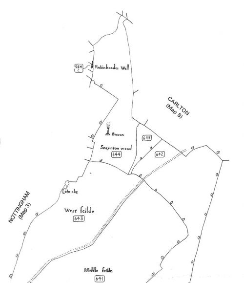
1609 - Robin Hood's Well (Nottingham)
From International Robin Hood Bibliography
| Record | |
|---|---|
| Date | 1609 |
| Topic | Plot of land next to Robin Hood's Well, Nottingham |
Site of Robin Hood's Well

Detail of the Sneinton portion of Peter Burgess's retracing of Richard Bankes's (c. ?1609) MS map (PRO MR 1142 pt. 1) / Bankes, Richard; Mastoris, Stephanos, ed.; Groves, Sue, ed. Sherwood Forest in 1609: a Crown Survey (Thoroton Society, Record Series, vol. XL) (Nottingham, 1997), Map 5: Sneinton.
By Henrik Thiil Nielsen, 2018-10-27. Revised by Henrik Thiil Nielsen, 2021-01-08.
Record
[1609:]
One (cot and two) other closes of pasture lying between the said woods and Robbinhoodes Well, in the occupation of Richard Hanton[1]
Source notes
MS variants listed in the printed edition are hardly significant for IRHB's purposes, except perhaps 'Hauton', 'Halton' for 'Hanton'.
The "said woods" are "[s]ix parcels of wood", on land common to Nottingham town, "called by the several names of New Coppice, Old Coppice and the Armytage, in the occupation of the town"[2]
The printed edition includes a plate with a detail of the map PRO MR 1142 showing "Robinhoodes Well" and adjacent plots.[3]
Lists
- Not included in Sussex, Lucy, compil. 'References to Robin Hood up to 1600', in: Knight, Stephen. Robin Hood: A Complete Study of the English Outlaw (Oxford, UK; Cambridge, Massachusetts: Blackwell, 1994), pp. 262-88.
Sources
- Bankes, Richard; Mastoris, Stephanos, ed.; Groves, Sue, ed. Sherwood Forest in 1609: a Crown Survey (Thoroton Society, Record Series, vol. XL) (Nottingham, 1997), p. 67, item No. 584.
Also see
Notes
- ↑ Bankes, Richard; Mastoris, Stephanos, ed.; Groves, Sue, ed. Sherwood Forest in 1609: a Crown Survey (Thoroton Society, Record Series, vol. XL) (Nottingham, 1997), p. 67, item No. 584.
- ↑ Bankes, Richard; Mastoris, Stephanos, ed.; Groves, Sue, ed. Sherwood Forest in 1609: a Crown Survey (Thoroton Society, Record Series, vol. XL) (Nottingham, 1997), p. 67, item No, 582.
- ↑ Bankes, Richard; Mastoris, Stephanos, ed.; Groves, Sue, ed. Sherwood Forest in 1609: a Crown Survey (Thoroton Society, Record Series, vol. XL) (Nottingham, 1997), p. xxviii.
