
Little John's Mead (Upminster): Difference between revisions
m (Text replacement - "PnItemTop" to "PlaceNamesItemTop") |
m (Text replacement - "(subscription required)" to "(£)") |
||
| (6 intermediate revisions by the same user not shown) | |||
| Line 4: | Line 4: | ||
[[File:{{#var:Image}}|thumb|right|500px|Little John's Mead (red outline) and its larger neighbour, [[Robin Hood (Upminster)|Robin Hood]] (yellow outline) / Google Earth Street View.]]<div class="no-img"> | [[File:{{#var:Image}}|thumb|right|500px|Little John's Mead (red outline) and its larger neighbour, [[Robin Hood (Upminster)|Robin Hood]] (yellow outline) / Google Earth Street View.]]<div class="no-img"> | ||
<p id="byline">By Henrik Thiil Nielsen, 2018-02-19. Revised by {{#realname:{{REVISIONUSER}}}}, {{REVISIONYEAR}}-{{REVISIONMONTH}}-{{REVISIONDAY2}}.</p> | <p id="byline">By Henrik Thiil Nielsen, 2018-02-19. Revised by {{#realname:{{REVISIONUSER}}}}, {{REVISIONYEAR}}-{{REVISIONMONTH}}-{{REVISIONDAY2}}.</p> | ||
The 1842 tithe award for Upminster lists 'Little John's Mead' as the name of a close on the southeast side of Little Gaynes Lane in Hacton, Upminster. Its owner/occupier is listed as the Reverend M. Battiscombe, its state of cultivation as 'Pasture', its area as 1 acre, 3 roods and 26 perches ({{ | The 1842 tithe award for Upminster lists 'Little John's Mead' as the name of a close on the southeast side of Little Gaynes Lane in Hacton, Upminster. Its owner/occupier is listed as the Reverend M. Battiscombe, its state of cultivation as 'Pasture', its area as 1 acre, 3 roods and 26 perches ({{AcresRoodsPerchesToM2|1|3|26}} m<sup>2</sup>).<ref>Tithe award for Upminster, online at the [https://www.thegenealogist.com Genealogist], Piece 12, Sub-Piece 356, Image 013 (£); [https://www.thegenealogist.com Genealogist], Piece 12, Sub-Piece 356, Sub-Image 001; map (£). {{:Waller, William Chapman 1898a}}; see pp. 62, 73.</ref> The field immediately east of Little John's Mead was named [[Robin Hood (Upminster)|Robin Hood]]. | ||
Hacton House was located about halway to three quarters down the western perimeter of the area, and as it is a separate entry in the tithe award, its area – quite small in comparison to that of the Mead – is not included in the figure cited for the area above.{{ | Hacton House was located about halway to three quarters down the western perimeter of the area, and as it is a separate entry in the tithe award, its area – quite small in comparison to that of the Mead – is not included in the figure cited for the area above.{{PlaceNamesItemAllusionsAndRecords}} | ||
== Gazetteers == | == Gazetteers == | ||
* Not included in {{:Dobson, Richard Barrie 1976a}}, pp. 293-311. | * Not included in {{:Dobson, Richard Barrie 1976a}}, pp. 293-311. | ||
== MS sources == | == MS sources == | ||
* Tithe award for Upminster, online at the [https://www.thegenealogist.com Genealogist], Piece 12, Sub-Piece 356, Image 013 ( | * Tithe award for Upminster, online at the [https://www.thegenealogist.com Genealogist], Piece 12, Sub-Piece 356, Image 013 (£) | ||
* Accompanying map, online at the [https://www.thegenealogist.com Genealogist], Piece 12, Sub-Piece 356, Sub-Image 001 ( | * Accompanying map, online at the [https://www.thegenealogist.com Genealogist], Piece 12, Sub-Piece 356, Sub-Image 001 (£). | ||
== Printed sources == | == Printed sources == | ||
| Line 31: | Line 31: | ||
* [https://en.wikipedia.org/wiki/Upminster Wikipedia: Upminster.] | * [https://en.wikipedia.org/wiki/Upminster Wikipedia: Upminster.] | ||
{{ | {{PlaceNamesItemAlsoSee}} | ||
== Notes == | == Notes == | ||
| Line 38: | Line 38: | ||
<div id="gallery"> | <div id="gallery"> | ||
{{ | {{ImageGalleryIntroduction}} | ||
<gallery widths="195px"> | <gallery widths="195px"> | ||
File:little-johns-mead-upminster-google-earth-street-view.jpg|Little John's Mead (red outline) and its larger neighbour, [[Robin Hood (Upminster)|Robin Hood]] (yellow outline) / Google Earth Street View. | File:little-johns-mead-upminster-google-earth-street-view.jpg|Little John's Mead (red outline) and its larger neighbour, [[Robin Hood (Upminster)|Robin Hood]] (yellow outline) / Google Earth Street View. | ||
| Line 46: | Line 46: | ||
{{ | {{PlaceNamesItemNavigation}} | ||
Latest revision as of 03:47, 12 February 2021
| Locality | |
|---|---|
| Coordinate | 51.547806, 0.234751 |
| Adm. div. | Essex, now Greater London |
| Vicinity | SE side of Little Gaynes Lane in Hacton, Upminster |
| Type | Area |
| Interest | Robin Hood name |
| Status | Defunct? |
| First Record | 1842 |

By Henrik Thiil Nielsen, 2018-02-19. Revised by Henrik Thiil Nielsen, 2021-02-12.
The 1842 tithe award for Upminster lists 'Little John's Mead' as the name of a close on the southeast side of Little Gaynes Lane in Hacton, Upminster. Its owner/occupier is listed as the Reverend M. Battiscombe, its state of cultivation as 'Pasture', its area as 1 acre, 3 roods and 26 perches (7739.61 m2).[1] The field immediately east of Little John's Mead was named Robin Hood.
Hacton House was located about halway to three quarters down the western perimeter of the area, and as it is a separate entry in the tithe award, its area – quite small in comparison to that of the Mead – is not included in the figure cited for the area above.
Gazetteers
- Not included in Dobson, R. B., ed.; Taylor, J., ed. Rymes of Robyn Hood: an Introduction to the English Outlaw (London, 1976), pp. 293-311.
MS sources
- Tithe award for Upminster, online at the Genealogist, Piece 12, Sub-Piece 356, Image 013 (£)
- Accompanying map, online at the Genealogist, Piece 12, Sub-Piece 356, Sub-Image 001 (£).
Printed sources
Maps
Little John's Mead not labelled.
- 25" O.S. map Essex LXXV.5 (1897; rev. 1895)
- 25" O.S. map Essex LXXV.5 (1897; rev. 1895) (georeferenced)
- 6" O.S. map Essex LXXV.NW (1898; rev. 1895)
- 6" O.S. map Essex LXXV.NW (1898; rev. 1895) (georeferenced)
- 6" O.S. map Essex nLXXXVII.NE (1921; rev. 1915)
- 6" O.S. map Essex nLXXXVII.NE (c. 1945; rev. 1938)
- 1:25,000 O.S. map TQ58 (1959; surveyed 1938-55) (georeferenced)
- 1:1 million–1:10k (1900s) (georeferenced).
Background
Also see
Notes
- ↑ Tithe award for Upminster, online at the Genealogist, Piece 12, Sub-Piece 356, Image 013 (£); Genealogist, Piece 12, Sub-Piece 356, Sub-Image 001; map (£). Waller, William Chapman, compil. 'Essex Field Names: Part II.—The Hundreds of Beacontree, Chafford, and Barstable, with the Liberty of Havering', Transactions of the Essex Archæological Society, New Series, vol. VI (1898), pp. 60-84; see pp. 62, 73.
Image gallery
Click any image to display it in the lightbox, where you can navigate between images by clicking in the right or left side of the current image.
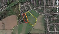
Little John's Mead (red outline) and its larger neighbour, Robin Hood (yellow outline) / Google Earth Street View.
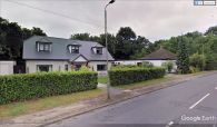
These two houses on the SE side of Little Gaynes Lane stand in the NW end of the former Little John's Mead.
