
Howe Robin (Crosby Ravensworth Fell): Difference between revisions
mNo edit summary |
mNo edit summary |
||
| (21 intermediate revisions by 2 users not shown) | |||
| Line 1: | Line 1: | ||
__NOTOC__{{ | __NOTOC__{{PlaceNamesItemTop|Lat=54.4882|Lon=-2.5812|AdministrativeDivision=Westmorland|Vicinity=Crosby Ravensworth Fell, ''c.'' 1.7 km N of Orton|Type=Prehistoric site|Interest=Robin Hood name|Status=Extant|Demonym=|Riding=|GreaterLondon=|Year=1859|Aka=|Century=|Cluster1=Crosby Ravensworth Fell|Cluster2=|Cluster3=|Image=michael-graham-howe-robin.jpg|Postcards=|ExtraCat1=|ExtraCat2=|ExtraCat3=|ExtraCat4=|ExtraCat5=|GeopointPrefix=|GeopointSuffix=|StatusSuffix=|DatePrefix=|DateSuffix=}} | ||
{{#display_map:{{#var:Coords}}~{{#replace:{{PAGENAME}}|'|'}}|width=34%}}<div class="pnMapLegend">Robin | {{#display_map:{{#var:Coords}}~{{#replace:{{PAGENAME}}|'|'}}|width=34%|enablefullscreen=yes}}<div class="pnMapLegend">Howe Robin.</div> | ||
[[File:michael-graham-howe-robin.jpg|thumb|right|500px|Limestone Pavement on Crosby Ravensworth Fell / | [[File:michael-graham-howe-robin.jpg|thumb|right|500px|Limestone Pavement on Crosby Ravensworth Fell / [http://www.geograph.org.uk/photo/5067255 Michael Graham, 30 July 2016, Creative Commons, via Geograph.]]]<div class="no-img"> | ||
<p id="byline">By Henrik Thiil Nielsen, 2017-05-11. Revised by {{#realname:{{REVISIONUSER}}}}, {{REVISIONYEAR}}-{{REVISIONMONTH}}-{{REVISIONDAY2}}.</p> | <p id="byline">By Henrik Thiil Nielsen, 2017-05-11. Revised by {{#realname:{{REVISIONUSER}}}}, {{REVISIONYEAR}}-{{REVISIONMONTH}}-{{REVISIONDAY2}}.</p> | ||
Howe Robin is a probably prehistoric site on Crosby Ravensworth Fell. A. H. Smith suggests in ''The Place-Names of Westmorland'' that the name may have been inspired by that of Robin Hood and points to a possible connection with [[Robin Hood's Grave (Crosby Ravensworth Fell)|Robin Hood's Grave]], ''c.'' 650 m NNW of the Howe. The first element, 'Howe', a reflex of 'haugr', means 'hill'. The earliest record of the name known to Smith is an 1859 MS Ordnance Survey name book.<ref>{{:Smith, Albert Hugh 1967a}}, pt. II, p. 160; and see pt. I, p. lxvi for source reference.</ref> The allusion cited below, dated ''c.'' 1860, is thus not much later. | |||
Howe Robin is a probably prehistoric site on Crosby Ravensworth Fell. A.H. Smith suggests in ''The Place-Names of Westmorland'' that the name may have been inspired by that of Robin Hood and points to a possible connection with [[Robin Hood's Grave (Crosby Ravensworth Fell)|Robin Hood's Grave]], ''c.'' 650 m NNW of the Howe. The first element, 'Howe', a reflex of 'haugr', means 'hill'. The earliest record of the name known to Smith is an 1859 MS Ordnance Survey name book.<ref>{{:Smith, Albert Hugh 1967a}}, pt. II, p. 160; and see pt. I, p. lxvi for source reference.</ref> The allusion cited below, dated ''c.'' 1860, is thus not much later. | |||
According to PastScape, the Howe, surveyed by archaeologists in 1996, is possibly neolithic, a roughly heart-shaped area of limestone pavement measuring 250 x 220 metres, in part encircled by the natural limestone escarpment. The surviving scarp is discontinuous, 0.8–1.5 metres high, topped in places by an earthen bank, 2.2 metres at its widest, and 0.3 metres high. There are traces of artifical ditches. Stone Age pottery and other implements as well as flakes have been found within and near the enclosure, but a neolithic date cannot be established with certainty.<ref>[http://www.pastscape.org.uk/hob.aspx?hob_id=1057514 PastScape: Howe Robin.] See further {{:Brown, Moraig 1996a}}.</ref>{{ | According to PastScape, the Howe, surveyed by archaeologists in 1996, is possibly neolithic, a roughly heart-shaped area of limestone pavement measuring 250 x 220 metres, in part encircled by the natural limestone escarpment. The surviving scarp is discontinuous, 0.8–1.5 metres high, topped in places by an earthen bank, 2.2 metres at its widest, and 0.3 metres high. There are traces of artifical ditches. Stone Age pottery and other implements as well as flakes have been found within and near the enclosure, but a neolithic date cannot be established with certainty.<ref>[http://www.pastscape.org.uk/hob.aspx?hob_id=1057514 PastScape: Howe Robin.] See further {{:Brown, Moraig 1996a}}.</ref>{{PlaceNamesItemAllusionsAndRecords}} | ||
== Gazetteers == | == Gazetteers == | ||
* Noted in {{:Dobson, Richard Barrie 1976a}}, p. 305, ''s.n.'' Robin Hood's Grave''. | * Noted in {{:Dobson, Richard Barrie 1976a}}, p. 305, ''s.n.'' Robin Hood's Grave''. | ||
| Line 15: | Line 13: | ||
* {{:Smith, Albert Hugh 1967a}}, pt. II, p. 160; and see pt. I, pp. lxvi, lxviii for source references. | * {{:Smith, Albert Hugh 1967a}}, pt. II, p. 160; and see pt. I, pp. lxvi, lxviii for source references. | ||
== Maps == | == Maps == | ||
* | * 25" O.S. map ''Westmorland'' XXI.12 (1861; surveyed ''c.'' 1858-59). No copy in NLS | ||
* [http://maps.nls.uk/view/125823393#zoom=4&lat=10112&lon=14222&layers=BT 25" O.S. map ''Westmorland'' XXI.12 (1898; rev. 1897)] | * [http://maps.nls.uk/view/125823393#zoom=4&lat=10112&lon=14222&layers=BT 25" O.S. map ''Westmorland'' XXI.12 (1898; rev. 1897)] | ||
* [http://maps.nls.uk/view/101104950#zoom=5&lat=5714&lon=7182&layers=BT 6" O.S. map ''Westmorland'' XXI.SE (1899; rev. 1897)] | * [http://maps.nls.uk/view/101104950#zoom=5&lat=5714&lon=7182&layers=BT 6" O.S. map ''Westmorland'' XXI.SE (1899; rev. 1897)] | ||
| Line 25: | Line 23: | ||
== Discussion == | == Discussion == | ||
* --> | * --> | ||
== Background == | == Background == | ||
* {{:Brown, Moraig 1996a}} | * {{:Brown, Moraig 1996a}} | ||
| Line 31: | Line 30: | ||
* --> | * --> | ||
{{ | {{PlaceNamesItemAlsoSee}} | ||
== Notes == | == Notes == | ||
<references/> | <references/> | ||
</div> | |||
<div id="gallery"> | |||
< | {{ImageGalleryIntroduction}} | ||
{{ | |||
<gallery widths="195px"> | <gallery widths="195px"> | ||
File:michael-graham-howe-robin.jpg|Limestone Pavement on Crosby Ravensworth Fell / | File:michael-graham-howe-robin.jpg|Limestone Pavement on Crosby Ravensworth Fell / [http://www.geograph.org.uk/photo/5067255 Michael Graham, 30 July 2016, Creative Commons, via Geograph.] | ||
File:david-brown-howe-robin.jpg|Limestone on Howe Robin / | File:david-brown-howe-robin.jpg|Limestone on Howe Robin / [http://www.geograph.org.uk/photo/1734319 David Brown, 3 Mar. 2010, Creative Commons, via Geograph.] | ||
</gallery> | </gallery> | ||
</div> | |||
{{ | {{PlaceNamesItemNavigation}} | ||
Latest revision as of 18:07, 12 April 2021
| Locality | |
|---|---|
| Coordinate | 54.4882, -2.5812 |
| Adm. div. | Westmorland |
| Vicinity | Crosby Ravensworth Fell, c. 1.7 km N of Orton |
| Type | Prehistoric site |
| Interest | Robin Hood name |
| Status | Extant |
| First Record | 1859 |

By Henrik Thiil Nielsen, 2017-05-11. Revised by Henrik Thiil Nielsen, 2021-04-12.
Howe Robin is a probably prehistoric site on Crosby Ravensworth Fell. A. H. Smith suggests in The Place-Names of Westmorland that the name may have been inspired by that of Robin Hood and points to a possible connection with Robin Hood's Grave, c. 650 m NNW of the Howe. The first element, 'Howe', a reflex of 'haugr', means 'hill'. The earliest record of the name known to Smith is an 1859 MS Ordnance Survey name book.[1] The allusion cited below, dated c. 1860, is thus not much later.
According to PastScape, the Howe, surveyed by archaeologists in 1996, is possibly neolithic, a roughly heart-shaped area of limestone pavement measuring 250 x 220 metres, in part encircled by the natural limestone escarpment. The surviving scarp is discontinuous, 0.8–1.5 metres high, topped in places by an earthen bank, 2.2 metres at its widest, and 0.3 metres high. There are traces of artifical ditches. Stone Age pottery and other implements as well as flakes have been found within and near the enclosure, but a neolithic date cannot be established with certainty.[2]Allusions
1860 - Bland, John Salkeld - Vale of Lyvenett (1)
The word How, Danish—a hill, is generally significant of a mound, but is often applied to the whole, as Sill How, Raise How, Bousfield How, How Arcles, How Neuk and How Robin; on each of which are mounds. Raise is an older word of similar meaning, and is applied more directly to a mound, as Raise How on Bank Moor. This name is more common in the neighbourhood of Shap. Pen, of Cambro-Celtic origin, having the same meaning, is found in Penhurrock. Others again bear the ordinary name of Hill, as Iren Hill, Round Hill, &c. Though these mounds have been raised by different people each in their day, yet they are often found to have been named or rather called Hills by whatever word in the language or dialect of the succeeding races expressed the same. Others again there are bearing names peculiar to themselves, as Iren Hill, Sill How, Hollinstump, Penhurrock, Robin Hood's Grave, Lady's Mound, &c. Though they are numerous, yet many of them have been opened by the hill-breakers of the last [p. 13:] century, or been more or less ravaged for the sake of stones, earth, &c.; for this reason it is difficult to distinguish those belonging to different ages, though it is highly probable the great majority are British.[3]
Gazetteers
- Noted in Dobson, R. B., ed.; Taylor, J., ed. Rymes of Robyn Hood: an Introduction to the English Outlaw (London, 1976), p. 305, s.n. Robin Hood's Grave.
Sources
- Lindsay, David, compil. An Inventory of the Historical Monuments in Westmorland (Royal Commission on Historical Monuments, England) (London, 1936), p. 90, item No. 50.
- Smith, A.H. The Place-Names of Westmorland (English Place-Name Society, vols. XLII, XLIII) (Cambridge, 1967), pt. II, p. 160; and see pt. I, pp. lxvi, lxviii for source references.
Maps
- 25" O.S. map Westmorland XXI.12 (1861; surveyed c. 1858-59). No copy in NLS
- 25" O.S. map Westmorland XXI.12 (1898; rev. 1897)
- 6" O.S. map Westmorland XXI.SE (1899; rev. 1897)
- 6" O.S. map Westmorland XXI.SE (1899; rev. 1897) (georeferenced)
- 25" O.S. map Westmorland XXI.12 (1915; rev. 1912)
- 6" O.S. map Westmorland XXI.SE (1920; rev. 1912)
- 6" O.S. map Westmorland XXI.SE (c. 1936; rev. 1912)
- 6" O.S. map Westmorland XXI.SE (c. 1946; rev. 1912).
Background
- [Brown, Moraig]; [Barber, Martyn]; [Topping, Peter], ed. Howe Robin, Crosby Ravensworth, Cumbria, NMR Number NY 61 SW 75, Industry and Enclosure in the Neolithic (Royal Commission on the Historical Monuments of England) (Cambridge, 1996)
- PastScape: Howe Robin.
Also see
Notes
- ↑ Smith, A.H. The Place-Names of Westmorland (English Place-Name Society, vols. XLII, XLIII) (Cambridge, 1967), pt. II, p. 160; and see pt. I, p. lxvi for source reference.
- ↑ PastScape: Howe Robin. See further [Brown, Moraig]; [Barber, Martyn]; [Topping, Peter], ed. Howe Robin, Crosby Ravensworth, Cumbria, NMR Number NY 61 SW 75, Industry and Enclosure in the Neolithic (Royal Commission on the Historical Monuments of England) (Cambridge, 1996).
- ↑ Bland, John Salkeld; Parker, F. H. M, ed. The Vale of Lyvennet, its Picturesque Peeps and Legendary Lore: a Manuscript Book (Kendal, 1910), pp. 12-13.
Image gallery
Click any image to display it in the lightbox, where you can navigate between images by clicking in the right or left side of the current image.
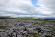
Limestone Pavement on Crosby Ravensworth Fell / Michael Graham, 30 July 2016, Creative Commons, via Geograph.
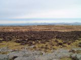
Limestone on Howe Robin / David Brown, 3 Mar. 2010, Creative Commons, via Geograph.
