
Robin Hood's Butt (Askerton)
| Locality | |
|---|---|
| Coordinate | 55.0388, -2.6594 |
| Adm. div. | Cumberland |
| Vicinity | c. 3.9 km NE of Askerton and c. 1.4 km NNW of Spadeadam |
| Type | Prehistoric site |
| Interest | Robin Hood name |
| Status | Extant |
| First Record | 1598 |
| A.k.a. | Robin Hood buttes; The Butt |

By Henrik Thiil Nielsen, 2017-08-26. Revised by Henrik Thiil Nielsen, 2021-01-07.
Robin Hood's Butt in Askerton parish, Cumberland, is a turf-covered mound, c. 13 m in diameter and up to 1.9 m in height. The mound, with some stone debris, is what remains of a Roman signal station which stood on the west side of the Maiden Way, a Roman Road from Birdoswald (by Hadrian's Wall) to Bewcastle. The foundations of a nearly square tower can be seen at the top. Based on the amount of debris it has been suggested that it was about 6 m high. Its walls of regularly coursed c. 85 cm thick stones were 3.5 to 6 m. wide externally. When the station was active, there was a ditch or drainage channel round the building, with a little causeway over or through it on the east side. The stone for the tower was supplied by two small quarries only 50 m to the west.[1]
Robin Hood's Butt is first mentioned in 1598 (see Record below). The locality is indicated as 'The Butt' tout court on a 6" O.S. map published in 1868 (based on surveying done in 1863) and on subsequent revisions at least until 1952 (see Maps section below). However, F. Haverfield, who excavated the site in 1900, noted in a report printed the subsequent year that "an estate map of 1830, belonging to Lord Carlisle [i.e. George Howard, 9th Earl of Carlisle (1843-1911)[2]], calls it Robin Hood's Butt, and the appellation seems to be still known in the neighbourhood".[3] I. A. Richmond in his 1933 paper on the site also knew it by that name. Recently, Andrew Curtis, who took one of the photos shown below, noted that the Butt is "[a]lso known as 'Robin Hood's Butt' (a possible reference to Robin Hood's Well nearby)"[4] He refers to the official archaeological website Pastscape – the source of the archaeological detail given above – which also uses the name 'Robin Hood's Well'. 'Robin Hood's Butt' seems to be the preferred name among archaeologists. It may still be in local use.
The English Place-Name Society lists the "Robin Hood buttes" figuring in the 1598 record cited below as belonging to the township of Farlam.[5] Dobson & Taylor repeat this localization,[6] However, as the record also lists several other localities in Askerton, it seems more likely that the reference concerns Robin Hood's Butt in Askerton. I have found no (other) evidence for a locality named 'Robin Hood's Butt' or 'Robin Hood Butts' in Farlam.
Records
1598 - Muster of Gilsland
Muster taken at Brampton, 5 September, 40 Elizabeth, before John
Musgrave land sergeant of Gillesland.
Comwhitton—Horses sufficient 9, insufficient 6, absent 2; nags sufficient 6, insufficient 3, absent 1; footmen 17; the Soots' spoils there 200l. and above.
Hayton—Not mustered "for the infection." The Scots' spoils there, 600l. and above.
Cumrewe—Sufficient 4, not sufficient 27; footmen 8; all spoiled by the Scots.
Castle Carrock—None appeared. Likewise spoiled.
Talkyn—Sufficient 8, not sufficient 4; footmen 8. "Spoyled."
Denton—Sufficient 5, not sufficient 30; footmen, 1. "Spoyled."
Over Denton—Sufficient 2, not sufficient 16; footmen 5. Spoiled.
Brampton—Sufficient horse 6, not sufficient 17; nags, sufficient 6, not sufficient 20; footmen 10.
Irthington—Sufficient 2, not sufficient 26; footmen 16.
Lyversdale—"None appeared. Spoiled and burned by the Scottes." [p. 558:]
Askerton—"Richard Grame als Langtowne, came not. All the rest of the tenantes are heryed and gone."
Leasehill—Sufficient 3, not sufficient 7.
Collingbancke—"Thre tenantes there all wayst."
Bowthrelbancke—"The tenantes there have never one horse."
Dallerlyne—"Never one horse there."
Fawcett Lease—"Fower tenantes neither horse nor other thinge."
Kirbeck Moore—"Fyve tenantes all wayst."
Jobs Clewghe—"All wayst," Jenkyn Foster, Alexander and Isabell Foster, " wayst."
Florihurst—Christofer Foster, sufficient, Arche Foster, not sufficient.
Allergarth—"All wayst."
Oxclose—"All wayst."
Chrakropp—"Three tenantes, sufficient."
Goeman Forde, Darman Steade, Bulman Stead, Sowter Moore, Harper-Hill, and Luckens—All Waste.
Spayd Adam—Footmen 8.
Walton—Sufficient 4, not sufficient 4; footmen 4.
Tryermayne—Sufficient 3, not sufficient 32; footmen 5.
Farlam—Sufficient 7, not sufficient 12; footmen 7.
On this view there were not 5 horses found worth 5l. a piece.
The Carletons have all the Queen's houses of strength in Gilsland in their hands and placed divers Scots in them. Thomas Carleton has Askerton house, demeane and mill; Tryermayne house and demeane, and mill called the Hole mill, Farlam hall and demeane; Templegarth house and half of the low forest, the Leyes hill, certain tenements called the Quarrell, three tenements at Lannerton and other mills "which I cannot nowe name." Lancellott Carleton has Naworth castle demeane and parke, Brampton foot hall, Brampton park, Brigwood park and the demeane of Brampton; the Tarne house and half of the forest; Netherton honse and mill, Denton hall and mill, "besydes dyvers percells of poore mens groundes, which he haith layd to them."
These are the several fees of the land sergeant ship of Gilsland, as may appear to your honor by the bailiffs' certificate.—The house demeane and mill of Askerton with appurtenances; one place called "Walton wood: another place called Clonsgilholme, of the rent of 17s. 8d.; 10 days' work of "medowe" called "Robin Hood buttes" within the forest. The appointing of the bailiff of Askerton and a farme hold thereto belonging; 20 nobles' fee, with certain oats, and fee called "Foster fee." Also felon's goods happening within the office.[7]
Gazetteers
- Dobson, R. B., ed.; Taylor, J., ed. Rymes of Robyn Hood: an Introduction to the English Outlaw (London, 1976), p. 295, s.n. Robin Hood Buttes.
Sources
- Armstrong, A. M.; Mawer, A.; Stenton, F. M.; Dickins, Bruce. The Place-Names of Cumberland (English Place-Name Society, vols. XX-XXII) (Cambridge, 1971), pt. I, p. 87
- Haverfield, F. 'Report of the Cumberland Excavation Committee for 1900', Transactions of the Cumberland and Westmorland Antiquarian and Archaeological Society, Series 2, vol. 1 (1901), pp. 75-92, see pp. 82-83
- Pastscape: Robin Hood's Butt
- Richmond, I. A. 'The Tower of Gillalees Beacon, called Robin Hood's Butt', Transactions of the Cumberland and Westmorland Antiquarian and Archaeological Society, Series 2, vol. 33 (1933), pp. 241-245.
Maps
- MS map in the possession (in 1900) of George Howard, 9th Earl of Carlisle. Not seen.[3]
- 6" O.S. map Cumberland VIII (1868; surveyed 1863)
- 6" O.S. map Cumberland VIII.SE (1901; rev. 1899)
- 6" O.S. map Cumberland VIII.SE (1901; rev. 1899) (georeferenced)
- 6" O.S. map Cumberland VIII.SE (1952; rev. 1946).
Illustrations
- According to I. A. Richmond, "Bruce[, John Collingwood], The Roman Wall, 3, pp. 264-5" is a lithograph of the tower at Robin Hood's Butt. He found that the lithograph 'dramatized' the monument. IRHB has not been able to locate the illustration in any of the editions of the book that are available for download.[8] Two other of Richmond's source references are incorrect. This one is imprecise at best.
Brief mention
Background
- Haverfield, Professor. 'Roman Notes', Transactions of the Cumberland and Westmorland Antiquarian and Archaeological Society, Series 2, vol. 16 (1916), pp. 282-86, see p. 282 n. *
- Topping, P. 'A "New" Signal Station in Cumbria', Britannia, vol. 18 (1987), pp. 298-300
- Wikipedia: Askerton
- Wikipedia: George Howard, 9th Earl of Carlisle
- Wikipedia: RAF Spadeadam
- Woolliscroft, D. J. 'The Outpost System of Hadrian's Wall', Transactions of the Cumberland and Westmorland Antiquarian and Archaeological Society, Series 2, vol. 88 (1988), pp. 23-28.
Brief mention
- Geograph: The Butt near Gillalees Beacon (by Andrew Curtis)
- Godwin, Jeremy. '"Robin Hood", near Langwathby', Transactions of the Cumberland and Westmorland Antiquarian and Archaeological Society, Series 2, vol. 96 (1996), p. 236
- Haverfield, F. 'Report of the Cumberland Excavation Committee, 1896', Transactions of the Cumberland and Westmorland Antiquarian & Archæological Society, Part II, vol. XIV (1897), pp. 413-33, see p. 430.
Also see
Notes
- ↑ Pastscape: Robin Hood's Butt.
- ↑ Wikipedia: George Howard, 9th Earl of Carlisle.
- ↑ 3.0 3.1 Haverfield, F. 'Report of the Cumberland Excavation Committee for 1900', Transactions of the Cumberland and Westmorland Antiquarian and Archaeological Society, Series 2, vol. 1 (1901), pp. 75-92, see p. 82.
- ↑ Geograph: The Butt near Gillalees Beacon (by Andrew Curtis).
- ↑ Armstrong, A. M.; Mawer, A.; Stenton, F. M.; Dickins, Bruce. The Place-Names of Cumberland (English Place-Name Society, vols. XX-XXII) (Cambridge, 1950-52), pt. I, p. 87.
- ↑ Dobson, R. B., ed.; Taylor, J., ed. Rymes of Robyn Hood: an Introduction to the English Outlaw (London, 1976), p. 295, s.n. Robin Hood Buttes.
- ↑ Bain, Joseph, ed. The Border Papers: Calendar of Letters and Papers Relating to the Affairs of the Borders of England and Scotland Preserved in Her Majesty's Public Record Office London (Edinburgh, 1894-96), vol. II, pp. 557-58.
- ↑ Richmond, I. A. 'The Tower of Gillalees Beacon, called Robin Hood's Butt', Transactions of the Cumberland and Westmorland Antiquarian and Archaeological Society, Series 2, vol. 33 (1933), pp. 241-245, see p. 241 & n. *.
Image gallery
Click any image to display it in the lightbox, where you can navigate between images by clicking in the right or left side of the current image.
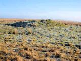
Robin Hood's Butt / Oliver Dixon, 2007; Creative Commons, via Geograph.
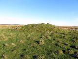
Robin Hood's Butt / Andrew Curtis, 2016; Creative Commons, via Geograph.
