
Robin Wood's Rock (Beadnell Bay): Difference between revisions
m (Text replacement - "{{#vardefine:Riding|NONE}}" to "{{#vardefine:Riding|}}") |
m (Text replacement - "ImgGalleryIntro" to "ImageGalleryIntroduction") |
||
| (47 intermediate revisions by 2 users not shown) | |||
| Line 1: | Line 1: | ||
{{ | __NOTOC__{{PlaceNamesItemTop|Lat=55.5384|Lon=-1.6285|AdministrativeDivision=Northumberland|Vicinity=In Beadnell Bay, North Sunderland|Type=Natural feature|Interest=Robin Hood name|Status=Extant|Demonym=|Riding=|GreaterLondon=|Year=1866|Aka=|Century=|Cluster1=|Cluster2=|Cluster3=|Image=robin-woods-rock-beadnell-bay-google-earth.jpg|Postcards=|ExtraCat1=Places named Robin Hood's Island|ExtraCat2=Wood for Hood|ExtraCat3=|ExtraCat4=|ExtraCat5=|ExtraLink1=|ExtraLink2=|ExtraLink3=|ExtraLink4=|ExtraLink5=|ExtraLinkName1=|ExtraLinkName2=|ExtraLinkName3=|ExtraLinkName4=|ExtraLinkName5=|GeopointPrefix=|GeopointSuffix=|StatusSuffix=|DatePrefix=|DateSuffix=}} | ||
{{#display_map:{{#var:Coords}}~{{#replace:{{PAGENAME}}|'|'}}|width=34%|enablefullscreen=yes}}<div class="pnMapLegend">Robin Wood's Rock.</div> | |||
[[File:robin-woods-rock-beadnell-bay-google-earth.jpg|thumb|right|500px|Robin Wood's Rock from the air / Google Earth Street View.]]<div class="no-img"> | |||
<p id="byline">By Henrik Thiil Nielsen, 2017-05-09. Revised by {{#realname:{{REVISIONUSER}}}}, {{REVISIONYEAR}}-{{REVISIONMONTH}}-{{REVISIONDAY2}}.</p> | |||
Robin Wood's Rock is a whin point in the North Sea, ''c.'' 480 meters from the coast at high tide, ''c.'' 140 meters at low tide, in Beadnell Bay, Northumberland. As Dobson & Taylor note, 'Wood' was a not uncommon alternative for 'Hood' in the 17th and 18th centuries.<ref>{{:Dobson, Richard Barrie 1976a}}, p. 300, ''s.n.'' Robin Hood's Rock.</ref> A standard work on the coastal geography of England and Wales cites the name of this locality as 'Robin Hood's Rock'.<ref>{{:Steers, J A 1946a}}, p. 454.</ref> So far the earliest is the 6" O.S. map of the area published in 1886 (see Maps section below). | |||
}} | |||
{{#display_map:{{#var: | |||
[[File:robin-woods-rock-beadnell-bay-google-earth.jpg|thumb|right|500px|Robin Wood's Rock from the air / Google Earth.]] | |||
<p id="byline">By Henrik Thiil Nielsen, 2017-05-09. Revised by {{#realname:{{REVISIONUSER}}}}, {{REVISIONYEAR}}-{{REVISIONMONTH}}-{{REVISIONDAY2}}.</p | |||
Robin Wood's Rock is a whin point in the North Sea, ''c.'' 480 meters from the coast at high tide, ''c.'' 140 meters at low tide, in Beadnell Bay, Northumberland. As Dobson & Taylor note, 'Wood' was a not uncommon alternative for 'Hood' in the 17th and 18th centuries.<ref>{{:Dobson, Richard Barrie 1976a}}, p. 300, ''s.n.'' Robin Hood's Rock.</ref> | |||
For other examples of 'Wood' for 'Hood', see the page on [[Wood for Hood]].{{PlaceNamesItemAllusionsAndRecords}} | |||
== Gazetteers == | |||
* {{:Dobson, Richard Barrie 1976a}}, p. 300, ''s.n.'' Robin Hood's Rock. | * {{:Dobson, Richard Barrie 1976a}}, p. 300, ''s.n.'' Robin Hood's Rock. | ||
== Sources == | |||
* {{:Steers, J A 1946a}}, p. 454. | * {{:Steers, J A 1946a}}, p. 454. | ||
== Maps == | |||
* [http://maps.nls.uk/view/102346266#zoom=5&lat=5061&lon=8884&layers=BT 6" O.S. map ''Northumberland'' XXII (1866; surveyed 1860)] | * [http://maps.nls.uk/view/102346266#zoom=5&lat=5061&lon=8884&layers=BT 6" O.S. map ''Northumberland'' XXII (1866; surveyed 1860)] | ||
* [http://maps.nls.uk/view/101026734#zoom=5&lat=5546&lon=2086&layers=BT 6" O.S. map ''Northumberland'' XXII.SE (1899; rev. 1896)] | * [http://maps.nls.uk/view/101026734#zoom=5&lat=5546&lon=2086&layers=BT 6" O.S. map ''Northumberland'' XXII.SE (1899; rev. 1896)] | ||
* [http://maps.nls.uk/geo/explore/#zoom=15&lat=55.5398&lon=-1.6272&layers=171&b=1 6" O.S. map ''Northumberland'' XXII.SE (1899; rev. 1896)] (georeferenced) | * [http://maps.nls.uk/geo/explore/#zoom=15&lat=55.5398&lon=-1.6272&layers=171&b=1 6" O.S. map ''Northumberland'' XXII.SE (1899; rev. 1896)] (georeferenced) | ||
* [http://maps.nls.uk/view/101027922#zoom=4&lat=2159&lon=5233&layers=BT 6" O.S. map ''Northumberland'' nXVIII.SE (1925; rev. 1922)] | * [http://maps.nls.uk/view/101027922#zoom=4&lat=2159&lon=5233&layers=BT 6" O.S. map ''Northumberland'' nXVIII.SE (1925; rev. 1922).] | ||
<!-- | <!-- | ||
== Postcards == | |||
* | * | ||
== | == Discussion == | ||
* --> | * --> | ||
== Background == | |||
* [[1883 - Bayzand, William - Coaching in and out of Oxford]] | * [[1883 - Bayzand, William - Coaching in and out of Oxford]] | ||
* [[Wood for Hood]].<!-- | * [[Wood for Hood]].<!-- | ||
== Brief mention == | |||
* | * --> | ||
{{PlaceNamesItemAlsoSee}} | |||
== Notes == | |||
<references/> | <references/> | ||
</div> | </div> | ||
{{ | |||
<gallery widths="195px">File:robin-woods-rock-beadnell-bay-google-earth.jpg | <div id="gallery"> | ||
File:geograph-robin-woods-rock-russel-wills.jpg | {{ImageGalleryIntroduction}} | ||
File:geograph-robin-woods-rock-n-chadwick.jpg|thumb|right|500px|Robin Wood's Rock fully exposed by the low tide / | <gallery widths="195px">File:robin-woods-rock-beadnell-bay-google-earth.jpg|Robin Wood's Rock from the air / Google Earth Street View. | ||
File:geograph-robin-woods-rock-russel-wills.jpg|Robin Wood's Rock partly exposed by the ebbing tide / [http://www.geograph.ie/profile/23874 Russel Wills, Creative Commons, via Geograph.] | |||
File:geograph-robin-woods-rock-n-chadwick.jpg|thumb|right|500px|Robin Wood's Rock fully exposed by the low tide / [http://www.geograph.org.uk/profile/3101 N. Chadwick, Creative Commons, via Geograph.] | |||
</gallery> | </gallery> | ||
</div> | |||
{{PlaceNamesItemNavigation}} | |||
{{ | |||
Latest revision as of 13:54, 7 January 2021
| Locality | |
|---|---|
| Coordinate | 55.5384, -1.6285 |
| Adm. div. | Northumberland |
| Vicinity | In Beadnell Bay, North Sunderland |
| Type | Natural feature |
| Interest | Robin Hood name |
| Status | Extant |
| First Record | 1866 |

By Henrik Thiil Nielsen, 2017-05-09. Revised by Henrik Thiil Nielsen, 2021-01-07.
Robin Wood's Rock is a whin point in the North Sea, c. 480 meters from the coast at high tide, c. 140 meters at low tide, in Beadnell Bay, Northumberland. As Dobson & Taylor note, 'Wood' was a not uncommon alternative for 'Hood' in the 17th and 18th centuries.[1] A standard work on the coastal geography of England and Wales cites the name of this locality as 'Robin Hood's Rock'.[2] So far the earliest is the 6" O.S. map of the area published in 1886 (see Maps section below).
For other examples of 'Wood' for 'Hood', see the page on Wood for Hood.
Gazetteers
- Dobson, R. B., ed.; Taylor, J., ed. Rymes of Robyn Hood: an Introduction to the English Outlaw (London, 1976), p. 300, s.n. Robin Hood's Rock.
Sources
Maps
- 6" O.S. map Northumberland XXII (1866; surveyed 1860)
- 6" O.S. map Northumberland XXII.SE (1899; rev. 1896)
- 6" O.S. map Northumberland XXII.SE (1899; rev. 1896) (georeferenced)
- 6" O.S. map Northumberland nXVIII.SE (1925; rev. 1922).
Background
Also see
Notes
- ↑ Dobson, R. B., ed.; Taylor, J., ed. Rymes of Robyn Hood: an Introduction to the English Outlaw (London, 1976), p. 300, s.n. Robin Hood's Rock.
- ↑ Steers, J.A. The Coastline of England and Wales (Cambridge, 1946), p. 454.
Image gallery
Click any image to display it in the lightbox, where you can navigate between images by clicking in the right or left side of the current image.
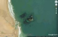
Robin Wood's Rock from the air / Google Earth Street View.
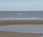
Robin Wood's Rock partly exposed by the ebbing tide / Russel Wills, Creative Commons, via Geograph.
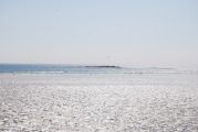
Robin Wood's Rock fully exposed by the low tide / N. Chadwick, Creative Commons, via Geograph.

