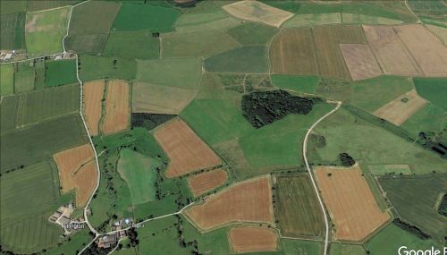
Robinhood Wood (Tritlington)
From International Robin Hood Bibliography
| Locality | |
|---|---|
| Coordinate | 55.233763, -1.664414 |
| Adm. div. | Northumberland |
| Vicinity | c. 800 m NE of Tritlington |
| Type | Natural feature |
| Interest | Robin Hood name |
| Status | Extant? |
| First Record | 1866 |
Robinhood Wood, Tritlington
By Henrik Thiil Nielsen, 2022-05-01. Revised by Henrik Thiil Nielsen, 2022-05-08.
Robinhood Wood, c. 800 m northeast of Tritlington, Northumberland, was known by that name as early as 1866.
The earliest record of the name known to IRHB is a 6" O.S. map of the area published in 1866 and based on a survey carried out in 1859 (see Maps below).
Gazetteers
- Not included in Dobson, R. B., ed.; Taylor, J., ed. Rymes of Robyn Hood: an Introduction to the English Outlaw (London, 1976), pp. 293-311.
Maps
- 6" O.S. map Northumberland LV.SW (1898; rev. 1896) (georeferenced)
- 6" O.S. map Northumberland LV (1866; surveyed 1859)
- 6" O.S. map Northumberland LV.SW (1898; rev. 1896)
- 6" O.S. map Northumberland nLX (1924; rev. 1921)
- 6" O.S. map Northumberland nLX.NE (1924; rev. 1921)
- 25" O.S. map Northumberland (Old Series) LV.14 (1897; rev. 1896) (georeferenced)
- 25" O.S. map Northumberland (Old Series) LV.14 (c. 1866; surveyed c. 1862). No copy in NLS
- 25" O.S. map Northumberland (Old Series) LV.14 (1897; rev. 1896)
- 25" O.S. map Northumberland (New Series) LX.3 (1923; rev. 1921).
Also see

