
Robin Hood and Little John (Rabley Heath): Difference between revisions
m (Text replacement - "=== Maps ===" to "== Maps ==") |
m (Text replacement - "UK Pub History" to "Pub History") |
||
| (38 intermediate revisions by 2 users not shown) | |||
| Line 1: | Line 1: | ||
__NOTOC__{{ | __NOTOC__{{PlaceNamesItemTop|Lat=51.857118|Lon=-0.207408|AdministrativeDivision=Hertfordshire|Vicinity=Rabley Heath Farm, Rabley Heath, Welwyn|Type=Public house|Interest=Robin Hood name|Status=Extant|Demonym=|Riding=|GreaterLondon=|Year=1871|Aka=|Century=|Cluster1=|Cluster2=|Cluster3=|Image=geograph-1323968-by-Robert-Edwards.jpg|Postcards=Yes|ExtraCat1=Places named after Little John|ExtraCat2=|ExtraCat3=|ExtraCat4=|ExtraCat5=|ExtraLink1=|ExtraLink2=|ExtraLink3=|ExtraLink4=|ExtraLink5=|ExtraLinkName1=|ExtraLinkName2=|ExtraLinkName3=|ExtraLinkName4=|ExtraLinkName5=|GeopointPrefix=|GeopointSuffix=|StatusSuffix=|DatePrefix=|DateSuffix=}} | ||
{{#display_map:{{#var:Coords}}~{{#replace:{{PAGENAME}}|'|'}}|width=34%}}<div class="pnMapLegend">Robin Hood and Little John.</div> | {{#display_map:{{#var:Coords}}~{{#replace:{{PAGENAME}}|'|'}}|width=34%|enablefullscreen=yes}}<div class="pnMapLegend">Robin Hood and Little John.</div> | ||
[[File:{{#var:Image}}|thumb|right|500px|Robin Hood and Little John / [http://www.geograph.org.uk/photo/1323968 Robert Edwards, 16 May 2009, Creative Commons, via Geograph.]]]<div class="no-img"> | |||
<p id="byline">By Henrik Thiil Nielsen, 2013-08-07. Revised by Henrik Thiil Nielsen, 2014-07-24.</p> | <p id="byline">By Henrik Thiil Nielsen, 2013-08-07. Revised by Henrik Thiil Nielsen, 2014-07-24.</p> | ||
The Robin Hood and Little John, a pub and restaurant in Rabley Heath, Welwyn, Hertfordshire, was in existence by 1871.<ref>[https://pubwiki.co.uk/HertsPubs/Codicote/RobinHood.shtml Pub History: Robin Hood, Rabley Heath, Codicote, Welwyn, Hertfordshire.]</ref> | |||
The earliest map reference is a 6" O.S. map published in 1884, based on surveying carried out in 1881 (see Maps below). Information on publicans for the years 1871 to 1937 can be found at Pub History.<ref>[https://pubwiki.co.uk/HertsPubs/Codicote/RobinHood.shtml Robin Hood, Rabley Heath, Codicote, Welwyn, Hertfordshire.]</ref> {{PlaceNamesItemAllusionsAndRecords}} | |||
== Gazetteers == | |||
* Not included in {{:Dobson, Richard Barrie 1976a|Dobson & Taylor}}, pp. 293-311. | |||
== Maps == | == Maps == | ||
* 25" O.S. map ''Hertfordshire'' XX.11 (''c.'' 1881; surveyed 1879-80). No copy in NLS | |||
* 25" O.S. map ''Hertfordshire'' XX.11 (''c.'' 1898; rev. ''c.'' 1897). No copy in NLS | |||
* [https://maps.nls.uk/geo/explore/#zoom=17&lat=51.8573&lon=-0.2074&layers=168&b=5 25" O.S. map ''Hertfordshire'' XX.11 (1924; rev. 1922)] (georeferenced) | |||
* [https://maps.nls.uk/view/104200036#zoom=4&lat=1918&lon=11729&layers=BT 25" O.S. map ''Hertfordshire'' XX.11 (1924; rev. 1922)] | |||
* [https://maps.nls.uk/view/104200033#zoom=4&lat=2238&lon=10677&layers=BT 25" O.S. map ''Hertfordshire'' XX.11 (1946; rev. 1939)] | |||
* [http://maps.nls.uk/view/102343301#zoom=6&lat=3669&lon=11023&layers=BT 6" O.S. map ''Hertfordshire'' XX (1884; surveyed 1881)] | * [http://maps.nls.uk/view/102343301#zoom=6&lat=3669&lon=11023&layers=BT 6" O.S. map ''Hertfordshire'' XX (1884; surveyed 1881)] | ||
* [https://maps.nls.uk/geo/explore/#zoom=16&lat=51.8579&lon=-0.2083&layers=6&b=5 6" O.S. map ''Hertfordshire'' XX.SE (1899; rev. 1897)] (georeferenced) | |||
* [http://maps.nls.uk/view/101579214#zoom=5&lat=3807&lon=3502&layers=BT 6" O.S. map ''Hertfordshire'' XX.SE (1899; rev. 1897)] | * [http://maps.nls.uk/view/101579214#zoom=5&lat=3807&lon=3502&layers=BT 6" O.S. map ''Hertfordshire'' XX.SE (1899; rev. 1897)] | ||
* [http://maps.nls.uk/view/101579211#zoom=5&lat=4129&lon=3610&layers=BT 6" O.S. map ''Hertfordshire'' XX.SE (1925; rev. 1922)] | * [http://maps.nls.uk/view/101579211#zoom=5&lat=4129&lon=3610&layers=BT 6" O.S. map ''Hertfordshire'' XX.SE (1925; rev. 1922)] | ||
* [http://maps.nls.uk/view/101579208#zoom=5&lat=4002&lon=3679&layers=BT 6" O.S. map ''Hertfordshire'' XX.SE (1950; rev. 1946-47).] | * [http://maps.nls.uk/view/101579208#zoom=5&lat=4002&lon=3679&layers=BT 6" O.S. map ''Hertfordshire'' XX.SE (1950; rev. 1946-47).] | ||
=== Background | == Sources == | ||
* [https://pubwiki.co.uk/HertsPubs/Codicote/RobinHood.shtml Pub History: Robin Hood, Rabley Heath, Codicote, Welwyn, Hertfordshire.] | |||
== Background == | |||
* [http://www.robinhoodandlittlejohnpub.co.uk Robin Hood & Little John, Rabley Heath.] | * [http://www.robinhoodandlittlejohnpub.co.uk Robin Hood & Little John, Rabley Heath.] | ||
{{ | {{PlaceNamesItemAlsoSee}} | ||
== Notes == | |||
<references/> | |||
</div> | |||
<div id="gallery"> | |||
{{ImageGalleryIntroduction}} | |||
<gallery widths="195px"> | |||
File:geograph-1323968-by-Robert-Edwards.jpg|Robin Hood and Little John / [http://www.geograph.org.uk/photo/1323968 Robert Edwards, 16 May 2009, Creative Commons, via Geograph.] | |||
File:geograph-4747408-by-Nigel-Cox.jpg|Oak tree at the Robin Hood and Little John Public House. This magnificent oak tree dwarfs the mainly single storey public house / [http://www.geograph.org.uk/photo/4747408 Nigel Cox, 22 Nov. 2015, Creative Commons, via Geograph.] | |||
File:geograph-4747401-by-Nigel-Cox.jpg|Robin Hood and Little John, a Grade II listed building / [http://www.geograph.org.uk/photo/4747401 Nigel Cox, 22 Nov. 2015, Creative Commons, via Geograph.] | |||
File:Hertfordshire Federation of Women's Institutes 19xxa-r.jpg|{{:Hertfordshire Federation of Women's Institutes 19xxa}} / HTN collection. | |||
</gallery> | |||
</div> | </div> | ||
{{PlaceNamesItemNavigation}} | |||
{{ | |||
Latest revision as of 15:33, 5 May 2022
| Locality | |
|---|---|
| Coordinate | 51.857118, -0.207408 |
| Adm. div. | Hertfordshire |
| Vicinity | Rabley Heath Farm, Rabley Heath, Welwyn |
| Type | Public house |
| Interest | Robin Hood name |
| Status | Extant |
| First Record | 1871 |

By Henrik Thiil Nielsen, 2013-08-07. Revised by Henrik Thiil Nielsen, 2014-07-24.
The Robin Hood and Little John, a pub and restaurant in Rabley Heath, Welwyn, Hertfordshire, was in existence by 1871.[1]
The earliest map reference is a 6" O.S. map published in 1884, based on surveying carried out in 1881 (see Maps below). Information on publicans for the years 1871 to 1937 can be found at Pub History.[2]
Gazetteers
- Not included in Dobson, R. B., ed.; Taylor, J., ed. Rymes of Robyn Hood: an Introduction to the English Outlaw (London, 1976), pp. 293-311.
Maps
- 25" O.S. map Hertfordshire XX.11 (c. 1881; surveyed 1879-80). No copy in NLS
- 25" O.S. map Hertfordshire XX.11 (c. 1898; rev. c. 1897). No copy in NLS
- 25" O.S. map Hertfordshire XX.11 (1924; rev. 1922) (georeferenced)
- 25" O.S. map Hertfordshire XX.11 (1924; rev. 1922)
- 25" O.S. map Hertfordshire XX.11 (1946; rev. 1939)
- 6" O.S. map Hertfordshire XX (1884; surveyed 1881)
- 6" O.S. map Hertfordshire XX.SE (1899; rev. 1897) (georeferenced)
- 6" O.S. map Hertfordshire XX.SE (1899; rev. 1897)
- 6" O.S. map Hertfordshire XX.SE (1925; rev. 1922)
- 6" O.S. map Hertfordshire XX.SE (1950; rev. 1946-47).
Sources
Background
Also see
Notes
Image gallery
Click any image to display it in the lightbox, where you can navigate between images by clicking in the right or left side of the current image.
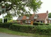
Robin Hood and Little John / Robert Edwards, 16 May 2009, Creative Commons, via Geograph.
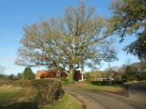
Oak tree at the Robin Hood and Little John Public House. This magnificent oak tree dwarfs the mainly single storey public house / Nigel Cox, 22 Nov. 2015, Creative Commons, via Geograph.
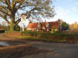
Robin Hood and Little John, a Grade II listed building / Nigel Cox, 22 Nov. 2015, Creative Commons, via Geograph.


