
Robin Hood Roundabout (Kingston-upon-Thames): Difference between revisions
mNo edit summary |
m (Text replacement - "ImgGalleryIntro" to "ImageGalleryIntroduction") |
||
| (20 intermediate revisions by 2 users not shown) | |||
| Line 1: | Line 1: | ||
__NOTOC__{{ | __NOTOC__{{PlaceNamesItemTop|Lat=51.435857|Lon=-0.256023|AdministrativeDivision=Surrey|Vicinity=On the A3, opposite Robin Hood Gate into Richmond Park|Type=Thoroughfare|Interest=Robin Hood name|Status=Extant|Demonym=English|Riding=|GreaterLondon=Yes|Year=1927|Aka=Robin Hood Gyratory|Century=|Cluster1=Kingston Vale|Cluster2=|Cluster3=|Image=robin-hood-roundabout-kingston-upon-thames.jpg|Postcards=|ExtraCat1=|ExtraCat2=|ExtraCat3=|ExtraCat4=|ExtraCat5=|ExtraLink1=|ExtraLink2=|ExtraLink3=|ExtraLink4=|ExtraLink5=|ExtraLinkName1=|ExtraLinkName2=|ExtraLinkName3=|ExtraLinkName4=|ExtraLinkName5=|GeopointPrefix=|GeopointSuffix=|StatusSuffix=|DatePrefix=|DateSuffix=}} | ||
{{#display_map:{{#var:Coords}}~{{#replace:{{PAGENAME}}|'|'}}|width=34%}}<div class="pnMapLegend">Robin Hood Roundabout, Kingston-upon-Thames</div> | {{#display_map:{{#var:Coords}}~{{#replace:{{PAGENAME}}|'|'}}|width=34%|enablefullscreen=yes}}<div class="pnMapLegend">Robin Hood Roundabout, Kingston-upon-Thames</div> | ||
[[File:{{#var: | [[File:{{#var:Image}}|thumb|right|500px|Robin Hood Roundabout, Kingston-upon-Thames / [https://www.geograph.org.uk/photo/675837 Nigel Cox, 30 jan. 2008, Creative Commons, via Geograph.]]]<div class="no-img"> | ||
<p id="byline">By Henrik Thiil Nielsen, 2019-02-23. Revised by {{#realname:{{REVISIONUSER}}}}, {{REVISIONYEAR}}-{{REVISIONMONTH}}-{{REVISIONDAY2}}.</p | <p id="byline">By Henrik Thiil Nielsen, 2019-02-23. Revised by {{#realname:{{REVISIONUSER}}}}, {{REVISIONYEAR}}-{{REVISIONMONTH}}-{{REVISIONDAY2}}.</p> | ||
The Robin Hood Roundabout on the A3 opposite Robin Hood Gate into Richmond Park was established in 1927.<ref>[https://www.geograph.org.uk/photo/675837 Geograph: TQ2172 : A3 Robin Hood Roundabout], by Nigel Cox.</ref> | The Robin Hood Roundabout on the A3 opposite Robin Hood Gate into Richmond Park was established in 1927.<ref>[https://www.geograph.org.uk/photo/675837 Geograph: TQ2172 : A3 Robin Hood Roundabout], by Nigel Cox.</ref> | ||
Since 1995 it is no longer possible to drive round it. It is now in simply the junction between the A3 and the A308 (Kingston Vale).<ref>[https://www.geograph.org.uk/photo/675837 Geograph: TQ2172 : A3 Robin Hood Roundabout], by Nigel Cox.</ref> | Since 1995 it is no longer possible to drive round it. It is now set in what is simply the junction between the A3 and the A308 (Kingston Vale).<ref>[https://www.geograph.org.uk/photo/675837 Geograph: TQ2172 : A3 Robin Hood Roundabout], by Nigel Cox.</ref> | ||
{{ | {{PlaceNamesItemAllusionsAndRecords}} | ||
== Gazetteers == | == Gazetteers == | ||
* Not included in {{:Dobson, Richard Barrie 1976a}}, pp. 293-311. | * Not included in {{:Dobson, Richard Barrie 1976a}}, pp. 293-311. | ||
| Line 24: | Line 24: | ||
* [https://maps.nls.uk/geo/explore/#zoom=17&lat=51.4373&lon=-0.2582&layers=168&b=5 25" O.S. map ''Surrey'' VII.9 (1897; rev. 1894)] (georeferenced) | * [https://maps.nls.uk/geo/explore/#zoom=17&lat=51.4373&lon=-0.2582&layers=168&b=5 25" O.S. map ''Surrey'' VII.9 (1897; rev. 1894)] (georeferenced) | ||
* [https://maps.nls.uk/geo/explore/#zoom=17&lat=51.4373&lon=-0.2582&layers=168&b=5 25" O.S. map ''London'' (1915- Numbered sheets) VIII.14 (1916; rev. 1913)] (georeferenced) | * [https://maps.nls.uk/geo/explore/#zoom=17&lat=51.4373&lon=-0.2582&layers=168&b=5 25" O.S. map ''London'' (1915- Numbered sheets) VIII.14 (1916; rev. 1913)] (georeferenced) | ||
* [https://maps.nls.uk/view/103313375#zoom=4&lat=2018&lon=3481&layers=BT 25" O.S. map ''London (1916; rev. 1913).] | * [https://maps.nls.uk/view/103313375#zoom=4&lat=2018&lon=3481&layers=BT 25" O.S. map ''London'' (1916; rev. 1913).] | ||
<!--== Discussion == | <!--== Discussion == | ||
== Background ==--> | == Background ==--> | ||
== Brief mention == | == Brief mention == | ||
* [https://www.sabre-roads.org.uk/wiki/index.php?title=Robin_Hood_(Kingston) Sabre: Robin Hood (Kingston).] | * [https://www.sabre-roads.org.uk/wiki/index.php?title=Robin_Hood_(Kingston) Sabre: Robin Hood (Kingston).] | ||
{{ | {{PlaceNamesItemAlsoSee}} | ||
== Notes == | == Notes == | ||
<references/> | <references/> | ||
</div> | |||
< | <div id="gallery"> | ||
{{ | {{ImageGalleryIntroduction}} | ||
<gallery widths="195px"> | <gallery widths="195px"> | ||
File:robin-hood-roundabout-kingston-upon-thames.jpg|Robin Hood Roundabout, Kingston-upon-Thames / [https://www.geograph.org.uk/photo/675837 Nigel Cox, 30 jan. 2008, Creative Commons via Geograph.] | File:robin-hood-roundabout-kingston-upon-thames.jpg|Robin Hood Roundabout, Kingston-upon-Thames / [https://www.geograph.org.uk/photo/675837 Nigel Cox, 30 jan. 2008, Creative Commons, via Geograph.] | ||
File:geograph-2575518-by-N-Chadwick.jpg|A3, Robin Hood Roundabout / [https://www.geograph.org.uk/photo/2575518 N. Chadwick, 7 May 2011, Creative Commons via Geograph.] | File:geograph-2575518-by-N-Chadwick.jpg|A3, Robin Hood Roundabout / [https://www.geograph.org.uk/photo/2575518 N. Chadwick, 7 May 2011, Creative Commons, via Geograph.] | ||
File:geograph-2575532-by-N-Chadwick.jpg|Robin Hood Roundabout / [https://www.geograph.org.uk/photo/2575532 N. Chadwick, 7 May 2011, Creative Commons via Geograph.] | File:geograph-2575532-by-N-Chadwick.jpg|Robin Hood Roundabout / [https://www.geograph.org.uk/photo/2575532 N. Chadwick, 7 May 2011, Creative Commons, via Geograph.] | ||
File:geograph-4184412-by-David-Howard.jpg|Robin Hood Roundabout / [https://www.geograph.org.uk/photo/4184412 David Howard 28 Sep. 2014, Creative Commons, via Geograph.] | |||
</gallery> | </gallery> | ||
</div> | |||
{{PlaceNamesItemNavigation}} | |||
{{ | |||
Latest revision as of 13:53, 7 January 2021
| Locality | |
|---|---|
| Coordinate | 51.435857, -0.256023 |
| Adm. div. | Surrey, now Greater London |
| Vicinity | On the A3, opposite Robin Hood Gate into Richmond Park |
| Type | Thoroughfare |
| Interest | Robin Hood name |
| Status | Extant |
| First Record | 1927 |
| A.k.a. | Robin Hood Gyratory |

By Henrik Thiil Nielsen, 2019-02-23. Revised by Henrik Thiil Nielsen, 2021-01-07.
The Robin Hood Roundabout on the A3 opposite Robin Hood Gate into Richmond Park was established in 1927.[1]
Since 1995 it is no longer possible to drive round it. It is now set in what is simply the junction between the A3 and the A308 (Kingston Vale).[2]
Gazetteers
- Not included in Dobson, R. B., ed.; Taylor, J., ed. Rymes of Robyn Hood: an Introduction to the English Outlaw (London, 1976), pp. 293-311.
Maps
- 6" O.S. map Middlesex XXI (1873; surveyed 1865-66)
- 6" O.S. map Surrey VII (1874; surveyed 1865)
- 6" O.S. map Surrey VII.SW (1899; rev. 1893-95) (georeferenced)
- 6" O.S. map Surrey VII.SW (1899; rev. 1893-95)
- 6" O.S. map Surrey VII.SW (1920; rev. 1911)
- 6" O.S. map Surrey VII.SW (c. 1933; rev. 1911)
- 6" O.S. map Surrey VII.SW (1936; rev. 1932-33)
- 6" O.S. map Surrey VII.SW (c. 1944; rev. 1938)
- 6" O.S. map Surrey VII.SW (c. 1946; rev. 1938).
- 6" O.S. map London X.SW (1894-96; rev. 1893-95)
- 25" O.S. map London (1869; surveyed 1865-67)
- 25" O.S. map Surrey VII.9 (1897; rev. 1894) (georeferenced)
- 25" O.S. map London (1915- Numbered sheets) VIII.14 (1916; rev. 1913) (georeferenced)
- 25" O.S. map London (1916; rev. 1913).
Brief mention
Also see
Notes
- ↑ Geograph: TQ2172 : A3 Robin Hood Roundabout, by Nigel Cox.
- ↑ Geograph: TQ2172 : A3 Robin Hood Roundabout, by Nigel Cox.
Image gallery
Click any image to display it in the lightbox, where you can navigate between images by clicking in the right or left side of the current image.
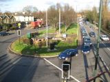
Robin Hood Roundabout, Kingston-upon-Thames / Nigel Cox, 30 jan. 2008, Creative Commons, via Geograph.
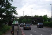
A3, Robin Hood Roundabout / N. Chadwick, 7 May 2011, Creative Commons, via Geograph.
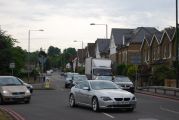
Robin Hood Roundabout / N. Chadwick, 7 May 2011, Creative Commons, via Geograph.
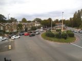
Robin Hood Roundabout / David Howard 28 Sep. 2014, Creative Commons, via Geograph.


