
Robin Hood Inn (Hazel Grove): Difference between revisions
mNo edit summary |
m (Text replacement - "* 25" map" to "* 25" O.S. map") |
||
| (6 intermediate revisions by the same user not shown) | |||
| Line 1: | Line 1: | ||
__NOTOC__{{PlaceNamesItemTop|Lat=53.367755|Lon=-2.094698|AdministrativeDivision=Cheshire|Vicinity=On the north side of Buxton Road, immediately west of Norbury Hollow Road|Type=Public house|Interest=Robin Hood name|Status=Defunct|Demonym=|Riding=|GreaterLondon=|Year=1849|Aka=|Century=|Cluster1=Hazel Grove|Cluster2=|Cluster3=|Image=rh-hazel-grove-google-earth.jpg|Postcards=|ExtraCat1=|ExtraCat2=|ExtraCat3=|ExtraCat4=|ExtraCat5=|ExtraLink1=Cherry Hinton place-name cluster|ExtraLink2=|ExtraLink3=|ExtraLink4=|ExtraLink5=|ExtraLinkName1=|ExtraLinkName2=|ExtraLinkName3=|ExtraLinkName4=|ExtraLinkName5=|GeopointPrefix=|GeopointSuffix=|StatusSuffix=|DatePrefix=|DateSuffix=}} | __NOTOC__{{PlaceNamesItemTop|Lat=53.367755|Lon=-2.094698|AdministrativeDivision=Cheshire|Vicinity=On the north side of Buxton Road, immediately west of Norbury Hollow Road|Type=Public house|Interest=Robin Hood name|Status=Defunct|Demonym=|Riding=|GreaterLondon=|Year=1849|Aka=|Century=|Cluster1=Hazel Grove|Cluster2=|Cluster3=|Image=rh-hazel-grove-google-earth.jpg|Postcards=|ExtraCat1=|ExtraCat2=|ExtraCat3=|ExtraCat4=|ExtraCat5=|ExtraLink1=Cherry Hinton place-name cluster|ExtraLink2=|ExtraLink3=|ExtraLink4=|ExtraLink5=|ExtraLinkName1=|ExtraLinkName2=|ExtraLinkName3=|ExtraLinkName4=|ExtraLinkName5=|GeopointPrefix=|GeopointSuffix=|StatusSuffix=|DatePrefix=|DateSuffix=}} | ||
{{#display_map:{{#var:Coords}}~{{#replace:{{PAGENAME}}|'|'}}|width=34%|enablefullscreen=yes}}<div class="pnMapLegend">The former Robin Hood Inn.</div> | {{#display_map:{{#var:Coords}}~{{#replace:{{PAGENAME}}|'|'}}|width=34%|enablefullscreen=yes}}<div class="pnMapLegend">The former Robin Hood Inn.</div> | ||
[[File:{{#var: | [[File:{{#var:Image}}|thumb|right|500px|The former Robin Hood Inn / Google Earth Street View.]]<div class="no-img"> | ||
<p id="byline">By Henrik Thiil Nielsen, 2017-01-19. Revised by {{#realname:{{REVISIONUSER}}}}, {{REVISIONYEAR}}-{{REVISIONMONTH}}-{{REVISIONDAY2}}.</p> | <p id="byline">By Henrik Thiil Nielsen, 2017-01-19. Revised by {{#realname:{{REVISIONUSER}}}}, {{REVISIONYEAR}}-{{REVISIONMONTH}}-{{REVISIONDAY2}}.</p> | ||
The long gone Robin Hood Inn situated on the north side of Buxton Road, immediately west of Norbury Hollow Road, south of Stockport, was in existence by 1849. | The long gone Robin Hood Inn situated on the north side of Buxton Road, immediately west of Norbury Hollow Road, south of Stockport, was in existence by 1849. | ||
The pub figures as 'Robin Hood Public House' in the 1849 tithe award for Norbury Moor. The then township of Norbury, with Norbury Moor, is now part of Hazel Grove. The landowner was | The pub figures as 'Robin Hood Public House' in the 1849 tithe award for Norbury Moor. The then township of Norbury, with Norbury Moor, is now part of Hazel Grove. The landowner was Thomas Legh, Esq., the occupier Elizabeth Hyde. The property covered an area of 21 perches ({{AcresRoodsPerchesToM2|0|0|21}} m<sup>2</sup>).<ref>1849 tithe award for the 'Township of Norbury in the Parish of Stockport' [actually Norbury Moor], online at the [https://www.thegenealogist.com Genealogist], Piece 05, sub-piece 297, Image 013, #321 (£); accompanying map, online at the [https://www.thegenealogist.com Genealogist], Piece 05, sub-piece 297, Sub-Image 001, #321 (£). Also see {{:Dodgson, John McNeal 1970a}}, vol. I, p. 288.</ref> A longish garden with an area of 30 perches ({{AcresRoodsPerchesToM2|0|0|30}} m<sup>2</sup>) extended westwards immediately north of – and behind – the neighbouring houses. Listed in the tithe award with the same occupier and landowner as the pub, this may well have been a pub garden rather than the private garden of the publican.<ref>The garden is plot No. 318 in the tithe award.</ref> Elizabeth Hyde is listed as 'vict[ualler]' in the 1850 History, Gazetteer & Directory of Cheshire.<ref>[http://specialcollections.le.ac.uk/digital/collection/p16445coll4/id/304310 University of Leicester: Special Collections Online: History, Gazetteer & Directory of Cheshire, 1850 – Page 335], under Norbury: 'Hyde Eliz. vict. Robin Hood'.</ref> | ||
Immediately east of the pub there was formerly a [[Robinhood Pool (Hazel Grove)|Robinhood Pool]] with a small island in it. A somewhat similar sitation is seen in Cherry Hinton, Cambridgeshire, where across the street from a public house named the [[Robin Hood (Cherry Hinton)|Robin Hood]] we find [[Robin Hood Dip (Cherry Hinton)|Robin Hood Dip]], which also contains a small island, the Giant's Grave. Unlike the latter, if the island in Robinhood Pool had a name, IRHB is not aware of it. | Immediately east of the pub there was formerly a [[Robinhood Pool (Hazel Grove)|Robinhood Pool]] with a small island in it. A somewhat similar sitation is seen in Cherry Hinton, Cambridgeshire, where across the street from a public house named the [[Robin Hood (Cherry Hinton)|Robin Hood]] we find [[Robin Hood Dip (Cherry Hinton)|Robin Hood Dip]], which also contains a small island, the Giant's Grave. Unlike the latter, if the island in Robinhood Pool had a name, IRHB is not aware of it. | ||
The pub and the pool are both included on the O.S. maps listed below. | |||
{{ | {{PlaceNamesItemAllusionsAndRecords}} | ||
== Gazetteers == | == Gazetteers == | ||
* Not included in {{:Dobson, Richard Barrie 1976a}}, pp. 293-311. | * Not included in {{:Dobson, Richard Barrie 1976a}}, pp. 293-311. | ||
== MS sources == | == MS sources == | ||
* 1849 tithe award for the 'Township of Norbury in the Parish of Stockport' [actually Norbury Moor], online at the [https://www.thegenealogist.com Genealogist], | * 1849 tithe award for the 'Township of Norbury in the Parish of Stockport' [actually Norbury Moor], online at the [https://www.thegenealogist.com Genealogist], Piece 05, sub-piece 297, Image 013, #318, #321 (£) | ||
* accompanying map, online at the [https://www.thegenealogist.com Genealogist], | * accompanying map, online at the [https://www.thegenealogist.com Genealogist], Piece 05, sub-piece 297, Sub-Image 001, #318, #321 (£). | ||
== Printed sources == | == Printed sources == | ||
* [http://specialcollections.le.ac.uk/digital/collection/p16445coll4/id/304310 University of Leicester: Special Collections Online: History, Gazetteer & Directory of Cheshire, 1850 – Page 335] | |||
* {{:Dodgson, John McNeal 1970a}}, vol. I, p. 288. | * {{:Dodgson, John McNeal 1970a}}, vol. I, p. 288. | ||
== Maps == | == Maps == | ||
* 25" map ''Cheshire'' XX.9 (''c.'' 1877; surveyed ''c.'' 1876). No copy in NLS. | * 25" O.S. map ''Cheshire'' XX.9 (''c.'' 1877; surveyed ''c.'' 1876). No copy in NLS. | ||
* [https://maps.nls.uk/geo/explore/#zoom=17&lat=53.36754&lon=-2.09432&layers=168&b=5 25" O.S. map ''Cheshire'' XX.9 (1898; rev. 1896)] (georeferenced) | * [https://maps.nls.uk/geo/explore/#zoom=17&lat=53.36754&lon=-2.09432&layers=168&b=5 25" O.S. map ''Cheshire'' XX.9 (1898; rev. 1896)] (georeferenced) | ||
* [https://maps.nls.uk/view/114582031#zoom=5&lat=5963&lon=7598&layers=BT 25" O.S. map ''Cheshire'' XX.9 (1898; rev. 1896–97)] | * [https://maps.nls.uk/view/114582031#zoom=5&lat=5963&lon=7598&layers=BT 25" O.S. map ''Cheshire'' XX.9 (1898; rev. 1896–97)] | ||
| Line 43: | Line 44: | ||
<gallery widths="195px"> | <gallery widths="195px"> | ||
rh-hazel-grove-google-earth.jpg|The former Robin Hood Inn / Google Earth Street View. | rh-hazel-grove-google-earth.jpg|The former Robin Hood Inn / Google Earth Street View. | ||
robin-hood-inn-hazel-grove-TM.jpg|Detail of 1849 tithe map. | robin-hood-inn-hazel-grove-TM.jpg|Detail of 1849 tithe map. Robin Hood Inn (#321); proprietor's garden (#318); Robinhood Pool (#269) (click or tap to enlarge) / {{GenealogistImage}} | ||
</gallery> | </gallery> | ||
{{PlaceNamesItemNavigation}} | {{PlaceNamesItemNavigation}} | ||
Latest revision as of 16:44, 8 May 2022
| Locality | |
|---|---|
| Coordinate | 53.367755, -2.094698 |
| Adm. div. | Cheshire |
| Vicinity | On the north side of Buxton Road, immediately west of Norbury Hollow Road |
| Type | Public house |
| Interest | Robin Hood name |
| Status | Defunct |
| First Record | 1849 |

By Henrik Thiil Nielsen, 2017-01-19. Revised by Henrik Thiil Nielsen, 2022-05-08.
The long gone Robin Hood Inn situated on the north side of Buxton Road, immediately west of Norbury Hollow Road, south of Stockport, was in existence by 1849.
The pub figures as 'Robin Hood Public House' in the 1849 tithe award for Norbury Moor. The then township of Norbury, with Norbury Moor, is now part of Hazel Grove. The landowner was Thomas Legh, Esq., the occupier Elizabeth Hyde. The property covered an area of 21 perches (531.15 m2).[1] A longish garden with an area of 30 perches (758.79 m2) extended westwards immediately north of – and behind – the neighbouring houses. Listed in the tithe award with the same occupier and landowner as the pub, this may well have been a pub garden rather than the private garden of the publican.[2] Elizabeth Hyde is listed as 'vict[ualler]' in the 1850 History, Gazetteer & Directory of Cheshire.[3]
Immediately east of the pub there was formerly a Robinhood Pool with a small island in it. A somewhat similar sitation is seen in Cherry Hinton, Cambridgeshire, where across the street from a public house named the Robin Hood we find Robin Hood Dip, which also contains a small island, the Giant's Grave. Unlike the latter, if the island in Robinhood Pool had a name, IRHB is not aware of it.
The pub and the pool are both included on the O.S. maps listed below.
Gazetteers
- Not included in Dobson, R. B., ed.; Taylor, J., ed. Rymes of Robyn Hood: an Introduction to the English Outlaw (London, 1976), pp. 293-311.
MS sources
- 1849 tithe award for the 'Township of Norbury in the Parish of Stockport' [actually Norbury Moor], online at the Genealogist, Piece 05, sub-piece 297, Image 013, #318, #321 (£)
- accompanying map, online at the Genealogist, Piece 05, sub-piece 297, Sub-Image 001, #318, #321 (£).
Printed sources
- University of Leicester: Special Collections Online: History, Gazetteer & Directory of Cheshire, 1850 – Page 335
- Dodgson, John McN.; Rumble, Alexander R. The Place-Names of Cheshire, pts. I-V (English Place-Name Society, vols. XLIV-XLVIII, LIV, LXXIV) (Cambridge, 1970-72; [s.l.], 1981; Nottingham, 1997), vol. I, p. 288.
Maps
- 25" O.S. map Cheshire XX.9 (c. 1877; surveyed c. 1876). No copy in NLS.
- 25" O.S. map Cheshire XX.9 (1898; rev. 1896) (georeferenced)
- 25" O.S. map Cheshire XX.9 (1898; rev. 1896–97)
- 25" O.S. map Cheshire XX.9 (1938; rev. 1936)
- 25" O.S. map Cheshire XX.9 (1934; rev. 1907)
- 6" O.S. map Cheshire XX (1881; surveyed 1871–72)
- 6" O.S. map Cheshire XX.SW (1899; rev. 1896-97) (georeferenced)
- 6" O.S. map Cheshire XX.SW (1899; rev. 1896-97)
- 6" O.S. map Cheshire XX.SW (1912; rev. 1907)
- 6" O.S. map Cheshire XX.SW (c. 1946; rev. 1938).
Also see
- Hazel Grove place-name cluster
- Cherry Hinton place-name cluster
- Public houses named after Robin Hood.
Notes
- ↑ 1849 tithe award for the 'Township of Norbury in the Parish of Stockport' [actually Norbury Moor], online at the Genealogist, Piece 05, sub-piece 297, Image 013, #321 (£); accompanying map, online at the Genealogist, Piece 05, sub-piece 297, Sub-Image 001, #321 (£). Also see Dodgson, John McN.; Rumble, Alexander R. The Place-Names of Cheshire, pts. I-V (English Place-Name Society, vols. XLIV-XLVIII, LIV, LXXIV) (Cambridge, 1970-72; [s.l.], 1981; Nottingham, 1997), vol. I, p. 288.
- ↑ The garden is plot No. 318 in the tithe award.
- ↑ University of Leicester: Special Collections Online: History, Gazetteer & Directory of Cheshire, 1850 – Page 335, under Norbury: 'Hyde Eliz. vict. Robin Hood'.
Image gallery
Click any image to display it in the lightbox, where you can navigate between images by clicking in the right or left side of the current image.

The former Robin Hood Inn / Google Earth Street View.
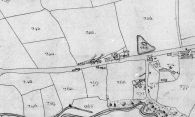
Detail of 1849 tithe map. Robin Hood Inn (#321); proprietor's garden (#318); Robinhood Pool (#269) (click or tap to enlarge) / © Crown Copyright Images reproduced by courtesy of The National Archives, London, England. www.NationalArchives.gov.uk and www.TheGenealogist.co.uk.
