
Robin Hood Deep Pit (Forest of Dean): Difference between revisions
mNo edit summary |
m (Text replacement - "No Copy in NLS" to "No copy in NLS") |
||
| (17 intermediate revisions by 2 users not shown) | |||
| Line 1: | Line 1: | ||
__NOTOC__{{ | __NOTOC__{{PlaceNamesItemTop|Lat=51.803956|Lon=-2.639432|AdministrativeDivision=Gloucestershire|Vicinity=''c.'' 85 m SW of Staunton Road (A4136) and ''c.'' 107 m W of Staunton Road (B4228)|Type=Establishment|Interest=Robin Hood name| | ||
Status=Extant|Demonym=|Riding=|GreaterLondon=|Year=1871|Aka=|Century=|Cluster1=Forest of Dean|Cluster2=Robin Hood Iron Mine|Cluster3=|Image=Robin-Hood-Deep-Pit-Coal-Mine-User-Album-80476.jpg|Postcards=|ExtraCat1=Places named Robin Hood's Mine|ExtraCat2=Robinhood place-names|ExtraCat3=|ExtraCat4=|ExtraCat5=|ExtraLink1=|ExtraLink2=|ExtraLink3=|ExtraLink4=|ExtraLink5=|ExtraLinkName1=|ExtraLinkName2=|ExtraLinkName3=|ExtraLinkName4=|ExtraLinkName5=|GeopointPrefix=|GeopointSuffix=|VicinitySuffix=|StatusSuffix=|DatePrefix=|DateSuffix=?}} | Status=Extant|Demonym=|Riding=|GreaterLondon=|Year=1871|Aka=|Century=|Cluster1=Forest of Dean|Cluster2=Robin Hood Iron Mine|Cluster3=|Image=Robin-Hood-Deep-Pit-Coal-Mine-User-Album-80476.jpg|Postcards=|ExtraCat1=Places named Robin Hood's Mine|ExtraCat2=Robinhood place-names|ExtraCat3=|ExtraCat4=|ExtraCat5=|ExtraLink1=|ExtraLink2=|ExtraLink3=|ExtraLink4=|ExtraLink5=|ExtraLinkName1=|ExtraLinkName2=|ExtraLinkName3=|ExtraLinkName4=|ExtraLinkName5=|GeopointPrefix=|GeopointSuffix=|VicinitySuffix=|StatusSuffix=|DatePrefix=|DateSuffix=?}} | ||
{{#display_map:{{#var:Coords}}~{{#replace:{{PAGENAME}}|'|'}}|width=34%}}<div class="pnMapLegend">At the pit site.</div> | {{#display_map:{{#var:Coords}}~{{#replace:{{PAGENAME}}|'|'}}|width=34%|enablefullscreen=yes}}<div class="pnMapLegend">At the pit site.</div> | ||
[[File:{{#var: | [[File:{{#var:Image}}|thumb|right|500px|At the pit site / Courtesy Aditnow forum user 'Lipsi'.]] | ||
<div class="no-img"><p id="byline">By Henrik Thiil Nielsen, 2018-10-22. Revised by {{#realname:{{REVISIONUSER}}}}, {{REVISIONYEAR}}-{{REVISIONMONTH}}-{{REVISIONDAY2}}. Photo courtesy Aditnow forum user 'Lipsi'. Thanks also to forum administrator Simon Lowe.</p> | <div class="no-img"> | ||
<p id="byline">By Henrik Thiil Nielsen, 2018-10-22. Revised by {{#realname:{{REVISIONUSER}}}}, {{REVISIONYEAR}}-{{REVISIONMONTH}}-{{REVISIONDAY2}}. Photo courtesy Aditnow forum user 'Lipsi'. Thanks also to forum administrator Simon Lowe.</p> | |||
Robin Hood Deep Pit was one of the two pits operated at the [[Robin Hood Iron Mine (Forest of Dean)|Robin Hood Iron Mine]] in the Forest of Dean. The mine is said to have started in 1871 and was certainly in operation by 1884, but IRHB is not aware if the deep pit dates from that time. | Robin Hood Deep Pit was one of the two pits operated at the [[Robin Hood Iron Mine (Forest of Dean)|Robin Hood Iron Mine]] in the Forest of Dean. The mine is said to have started in 1871 and was certainly in operation by 1884, but IRHB is not aware if the deep pit dates from that time. | ||
According to Wikipedia's article on the village of Coleford, the mine began operation in 1871,<ref>[https://en.wikipedia.org/wiki/Staunton,_near_Coleford,_Gloucestershire Wikipedia: Staunton, near Coleford, Gloucestershire.]</ref> and this may well be correct though no source is cited. The mine was certainly in operation by 1884, probably by 1880, for it is shown on a 6" O.S. map of the area published in 1884, based on surveying carried out 1879-80 (see Maps below). Some revisions of the map label the site "Robinhood Iron Mine", while others have "Robin Hood Iron Pit". The deep pit thus seems to have been within the roughly square area shown on the maps. If this is the case, [[Robin Hood Land Pit (Forest of Dean)|the mine's land pit]] must have been located elsewhere. See further IRHB's page on the [[Robin Hood Iron Mine (Forest of Dean)|Robin Hood Iron Mine.]]{{ | According to Wikipedia's article on the village of Coleford, the mine began operation in 1871,<ref>[https://en.wikipedia.org/wiki/Staunton,_near_Coleford,_Gloucestershire Wikipedia: Staunton, near Coleford, Gloucestershire.]</ref> and this may well be correct though no source is cited. The mine was certainly in operation by 1884, probably by 1880, for it is shown on a 6" O.S. map of the area published in 1884, based on surveying carried out 1879-80 (see Maps below). Some revisions of the map label the site "Robinhood Iron Mine", while others have "Robin Hood Iron Pit". The deep pit thus seems to have been within the roughly square area shown on the maps. If this is the case, [[Robin Hood Land Pit (Forest of Dean)|the mine's land pit]] must have been located elsewhere. See further IRHB's page on the [[Robin Hood Iron Mine (Forest of Dean)|Robin Hood Iron Mine.]]{{PlaceNamesItemAllusionsAndRecords}} | ||
== Gazetteers == | == Gazetteers == | ||
| Line 12: | Line 13: | ||
== Maps == | == Maps == | ||
* 25" O.S. map ''Monmouthshire'' XV.2 (''c.'' 1882; surveyed 1880). (No | * 25" O.S. map ''Monmouthshire'' XV.2 (''c.'' 1882; surveyed 1880). (No copy in NLS) | ||
* [https://maps.nls.uk/view/109725256#zoom=4&lat=3874&lon=13707&layers=BT 25" O.S. map ''Gloucestershire'' XXX.15 (1895; surveyed 1879-80)] | * [https://maps.nls.uk/view/109725256#zoom=4&lat=3874&lon=13707&layers=BT 25" O.S. map ''Gloucestershire'' XXX.15 (1895; surveyed 1879-80)] | ||
* [https://maps.nls.uk/view/109725259#zoom=4&lat=3840&lon=12879&layers=BT 25" O.S. map ''Gloucestershire'' XXX.15 (1902; rev. 1900)] | * [https://maps.nls.uk/view/109725259#zoom=4&lat=3840&lon=12879&layers=BT 25" O.S. map ''Gloucestershire'' XXX.15 (1902; rev. 1900)] | ||
* [https://maps.nls.uk/geo/explore/#zoom=17&lat=51.8036&lon=-2.6405&layers=168&b=5 25" O.S. map ''Monmouthshire'' XV.2 (1902; rev. 1900)] (georeferenced) | * [https://maps.nls.uk/geo/explore/#zoom=17&lat=51.8036&lon=-2.6405&layers=168&b=5 25" O.S. map ''Monmouthshire'' XV.2 (1902; rev. 1900)] (georeferenced) | ||
* [https://maps.nls.uk/view/135198586#zoom=4&lat=3196&lon=11653&layers=BT 25" O.S. map ''Monmouthshire'' XV.2 (1902; rev. 1900)] | * [https://maps.nls.uk/view/135198586#zoom=4&lat=3196&lon=11653&layers=BT 25" O.S. map ''Monmouthshire'' XV.2 (1902; rev. 1900)] | ||
* [https://maps.nls.uk/view/109725262#zoom=5&lat=3746&lon=12947&layers=BT 25" O.S. map ''Gloucestershire'' XXX.15 (1922; rev. 1920)] | * [https://maps.nls.uk/view/109725262#zoom=5&lat=3746&lon=12947&layers=BT 25" O.S. map ''Gloucestershire'' XXX.15 (1922; rev. 1920)] | ||
* [https://maps.nls.uk/view/101453349#zoom=4&lat=1862&lon=3873&layers=BT 6" O.S. map ''Gloucestershire'' XXX.SE (1884; surveyed 1878-80)] | * [https://maps.nls.uk/view/101453349#zoom=4&lat=1862&lon=3873&layers=BT 6" O.S. map ''Gloucestershire'' XXX.SE (1884; surveyed 1878-80)] | ||
* [https://maps.nls.uk/geo/explore/#zoom=16&lat=51.8039&lon=-2.6447&layers=6&b=5 6" O.S. map ''Gloucestershire'' XXX.SE (1903; rev. 1900)] (georeferenced) | * [https://maps.nls.uk/geo/explore/#zoom=16&lat=51.8039&lon=-2.6447&layers=6&b=5 6" O.S. map ''Gloucestershire'' XXX.SE (1903; rev. 1900)] (georeferenced) | ||
* [https://maps.nls.uk/view/101453346#zoom=4&lat=1938&lon=3696&layers=BT 6" O.S. map ''Gloucestershire'' XXX.SE (1903; rev. 1900)] | * [https://maps.nls.uk/view/101453346#zoom=4&lat=1938&lon=3696&layers=BT 6" O.S. map ''Gloucestershire'' XXX.SE (1903; rev. 1900)] | ||
* [https://maps.nls.uk/view/102186154#zoom=4&lat=4479&lon=6883&layers=BT 6" O.S. map ''Monmouthshire'' XV.NW (1903; rev. 1900)] | * [https://maps.nls.uk/view/102186154#zoom=4&lat=4479&lon=6883&layers=BT 6" O.S. map ''Monmouthshire'' XV.NW (1903; rev. 1900)] | ||
| Line 31: | Line 32: | ||
* [http://eprints.glos.ac.uk/3761/2/Mervyn%20Fox%20LOG.docx Transcript of interview with 88 year old former miner Mervyn Fox, conducted 30 Oct. 2015 by Jonathan Wright, sound Engineer: Jason Griffiths] | * [http://eprints.glos.ac.uk/3761/2/Mervyn%20Fox%20LOG.docx Transcript of interview with 88 year old former miner Mervyn Fox, conducted 30 Oct. 2015 by Jonathan Wright, sound Engineer: Jason Griffiths] | ||
* [https://en.wikipedia.org/wiki/Staunton,_near_Coleford,_Gloucestershire Wikipedia: Staunton, near Coleford, Gloucestershire.] | * [https://en.wikipedia.org/wiki/Staunton,_near_Coleford,_Gloucestershire Wikipedia: Staunton, near Coleford, Gloucestershire.] | ||
{{ | {{PlaceNamesItemAlsoSee}} | ||
== Notes == | == Notes == | ||
<references/> | <references/> | ||
</div> | |||
<div id="gallery"> | |||
< | {{ImageGalleryIntroduction}} | ||
{{ | |||
<gallery widths="195px"> | <gallery widths="195px"> | ||
Robin-Hood-Deep-Pit-Coal-Mine-User-Album-80476.jpg|At the pit site / Courtesy Aditnow forum user 'Lipsi'. | Robin-Hood-Deep-Pit-Coal-Mine-User-Album-80476.jpg|At the pit site / Courtesy Aditnow forum user 'Lipsi'. | ||
robin-hood-iron-pit-forest-of-dean-google-earth-street-view.jpg|Looking roughly SW from Stounton Road (A4136), | robin-hood-iron-pit-forest-of-dean-google-earth-street-view.jpg|Looking roughly SW from Stounton Road (A4136), it is a short, ''c.'' 85 m straight ahead walk to the site of the Robin Hood Iron Pit / Google Earth Street View. | ||
</gallery> | </gallery> | ||
</div> | |||
{{PlaceNamesItemNavigation}} | |||
{{ | |||
Latest revision as of 01:11, 13 February 2021
| Locality | |
|---|---|
| Coordinate | 51.803956, -2.639432 |
| Adm. div. | Gloucestershire |
| Vicinity | c. 85 m SW of Staunton Road (A4136) and c. 107 m W of Staunton Road (B4228) |
| Type | Establishment |
| Interest | Robin Hood name |
| Status | Extant |
| First Record | 1871? |

By Henrik Thiil Nielsen, 2018-10-22. Revised by Henrik Thiil Nielsen, 2021-02-13. Photo courtesy Aditnow forum user 'Lipsi'. Thanks also to forum administrator Simon Lowe.
Robin Hood Deep Pit was one of the two pits operated at the Robin Hood Iron Mine in the Forest of Dean. The mine is said to have started in 1871 and was certainly in operation by 1884, but IRHB is not aware if the deep pit dates from that time.
According to Wikipedia's article on the village of Coleford, the mine began operation in 1871,[1] and this may well be correct though no source is cited. The mine was certainly in operation by 1884, probably by 1880, for it is shown on a 6" O.S. map of the area published in 1884, based on surveying carried out 1879-80 (see Maps below). Some revisions of the map label the site "Robinhood Iron Mine", while others have "Robin Hood Iron Pit". The deep pit thus seems to have been within the roughly square area shown on the maps. If this is the case, the mine's land pit must have been located elsewhere. See further IRHB's page on the Robin Hood Iron Mine.
Gazetteers
- Not included in Dobson, R. B., ed.; Taylor, J., ed. Rymes of Robyn Hood: an Introduction to the English Outlaw (London, 1976), pp. 293-311.
Maps
- 25" O.S. map Monmouthshire XV.2 (c. 1882; surveyed 1880). (No copy in NLS)
- 25" O.S. map Gloucestershire XXX.15 (1895; surveyed 1879-80)
- 25" O.S. map Gloucestershire XXX.15 (1902; rev. 1900)
- 25" O.S. map Monmouthshire XV.2 (1902; rev. 1900) (georeferenced)
- 25" O.S. map Monmouthshire XV.2 (1902; rev. 1900)
- 25" O.S. map Gloucestershire XXX.15 (1922; rev. 1920)
- 6" O.S. map Gloucestershire XXX.SE (1884; surveyed 1878-80)
- 6" O.S. map Gloucestershire XXX.SE (1903; rev. 1900) (georeferenced)
- 6" O.S. map Gloucestershire XXX.SE (1903; rev. 1900)
- 6" O.S. map Monmouthshire XV.NW (1903; rev. 1900)
- 6" O.S. map Monmouthshire XV (1924; rev. 1918)
- 6" O.S. map Gloucestershire XXX (1924; rev. 1920-21)
- Map of the Railways of the Forest of Dean (1894); pit included on Staunton section as "Robin Hood".
Background
- Transcript of interview with 88 year old former miner Mervyn Fox, conducted 30 Oct. 2015 by Jonathan Wright, sound Engineer: Jason Griffiths
- Wikipedia: Staunton, near Coleford, Gloucestershire.
Also see
- Forest of Dean place-name cluster
- Robin Hood Iron Mine place-name cluster
- Places named Robin Hood's Mine
- Robinhood place-names.
Notes
Image gallery
Click any image to display it in the lightbox, where you can navigate between images by clicking in the right or left side of the current image.
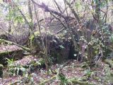
At the pit site / Courtesy Aditnow forum user 'Lipsi'.
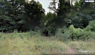
Looking roughly SW from Stounton Road (A4136), it is a short, c. 85 m straight ahead walk to the site of the Robin Hood Iron Pit / Google Earth Street View.
