
Robin Hood Iron Mine (Forest of Dean)
| Locality | |
|---|---|
| Coordinate | 51.8037, -2.6398 |
| Adm. div. | Gloucestershire |
| Vicinity | c. 85 m SW of Staunton Road (A4136) and c. 107 m W of Staunton Road (B4228) |
| Type | Establishment |
| Interest | Robin Hood name |
| Status | Extant |
| First Record | 1871 |
| A.k.a. | Robinhood Iron Mine; Robin Hood; Robin Hood Iron Pit |

By Henrik Thiil Nielsen, 2018-09-24. Revised by Henrik Thiil Nielsen, 2021-02-13. Photos courtesy Aditnow forum user 'Lipsi'. Thanks also to forum administrator Simon Lowe.
Robin Hood Iron Mine was located in Marian's Inclosure in the Forest of Dean. Said to have started in 1871, it was certainly in operation by 1884.
According to Wikipedia's article on the village of Coleford, the mine began operation in 1871,[1] and this may well be correct though no source is cited. The earliest map source for this place-name known to IRHB is a 6" O.S. map of the area published in 1884, based on surveying carried out 1879-80 (see Maps below). Some revisions of the map label the site "Robinhood Iron Mine", while others have "Robin Hood Iron Pit". The part of the Forest of Dean in which the mine was situated was known as Blake's Wood. A deep pit and a land pit were operated.
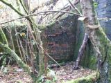
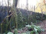
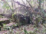
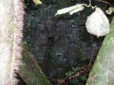
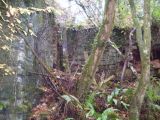
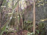
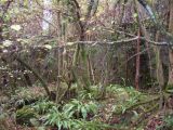
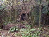
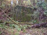
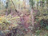
One of 39 active mining operations in the district during the 19th century or later, the Robin Hood Iron Mine was worked mainly for red oxide but also produced ochre for use in the paint industry. It closed in 1932 but was briefly reopened by the Ministry of Supply during WWII.[2] The forest has reclaimed the site to the extent that hardly any traces of the mining operation can be discerned on Google Maps satellite images. However, on the ground several are still visible, including the "[s]ite of a shaft (now sealed with an iron plate)" and the "[s]ite of an air shaft of unknown date, located c.60 metres south-west of Robin Hood Iron Pit, and possibly associated with that site". Among many other remains of mining and quarrying operations in the vicinity are a "[f]lat-topped mound of unknown date located in woodland to the north of the site of Robin Hood Iron Pit, near the A4136".[3] The O.S. maps listed below include details such as buildings, a shaft, an air shaft, ramparts or heaps of waste, a weighing machine, and access roads. With few conspicuous traces of the mine now remaining and hence so little reason for people in the area to have use for a name for it, the place-name is kept alive mainly by local historians and people interested in mining history and exploration. There are also a few references in the archaeological literature.[4]
"Marian" occurs as an element in the names of at least five localities in the vicinity, and until we have clear evidence to the contrary, it seems reasonable to believe these place-names may refer to Maid Marian.
Gazetteers
- Not included in Dobson, R. B., ed.; Taylor, J., ed. Rymes of Robyn Hood: an Introduction to the English Outlaw (London, 1976), pp. 293-311.
Sources
- Aditnow forum: Robin Hood Deep Pit Iron Mine (United Kingdom)
- Aditnow forum: Robin Hood Land Pit Iron Mine (United Kingdom)
- Hoyle, Jon; Gloucestershire County Council. The Forest of Dean, Gloucestershire: Archaeological Survey. Stage 1: Desk-Based Data Collection. Project Number 2727 ([s.l.], 2008), vol. 2, pp. 75 (SMR No. 13937), 169 (area 6126), 170 (area 6126), 177 (area 13922)
- Hoyle, Jon; Gloucestershire County Council. Research Framework for Forest of Dean District. Forest of Dean Archaeological Survey Stage 4: Module 3. Project Number 5291 ANL ([s.l.], 2017), pp. 121-37. Excellent overview of mining and quarrying operations in the area
- Mining History Research & Exploration: Index of mines in the Forest of Dean; click 'Forest of Dean' link.
Maps
- 25" O.S. map Monmouthshire XV.2 (c. 1882; surveyed 1880). (No copy in NLS)
- 25" O.S. map Gloucestershire XXX.15 (1895; surveyed 1879-80)
- 25" O.S. map Gloucestershire XXX.15 (1902; rev. 1900)
- 25" O.S. map Monmouthshire XV.2 (1902; rev. 1900) (georeferenced)
- 25" O.S. map Monmouthshire XV.2 (1902; rev. 1900)
- 25" O.S. map Gloucestershire XXX.15 (1922; rev. 1920)
- 6" O.S. map Gloucestershire XXX.SE (1884; surveyed 1878-80)
- 6" O.S. map Gloucestershire XXX.SE (1903; rev. 1900) (georeferenced)
- 6" O.S. map Gloucestershire XXX.SE (1903; rev. 1900)
- 6" O.S. map Monmouthshire XV.NW (1903; rev. 1900)
- 6" O.S. map Monmouthshire XV (1924; rev. 1918)
- 6" O.S. map Gloucestershire XXX (1924; rev. 1920-21)
- Map of the Railways of the Forest of Dean (1894); pit included on Staunton section as "Robin Hood".
Background
- BHO: Victoria County History: Gloucestershire: Vol. 5, pp. 326-54: Forest of Dean: Industry
- Hoyle, Jon; Gloucestershire County Council. The Forest of Dean, Gloucestershire: Archaeological Survey. Stage 1: Desk-Based Data Collection. Project Number 2727 ([s.l.], 2008), vol. 2, pp. 75 (SMR No. 13937), 169 (area 6126), 170 (area 6126), 177 (area 13922)
- Poggi, E Muriel. 'The Forest of Dean in Gloucestershire', Economic Geography, Vol. 6 (1930), pp. 309-20
- Transcript of interview with 88 year old former miner Mervyn Fox, conducted 30 Oct. 2015 by Jonathan Wright, sound Engineer: Jason Griffiths
- Wikipedia: Staunton, near Coleford, Gloucestershire.
Brief mention
- Green Bottom, Forest of Dean
- [White, Malcolm]. 'FoDCCAG', Royal Forest of Dean Caving Club, vol. 151 (Spring 2013), p. 2.
Also see
- Forest of Dean place-name cluster
- Robin Hood Iron Mine place-name cluster
- Places named Robin Hood's Mine
- Robinhood place-names.
Notes
- ↑ Wikipedia: Staunton, near Coleford, Gloucestershire.
- ↑ Hoyle, Jon; Gloucestershire County Council. Research Framework for Forest of Dean District. Forest of Dean Archaeological Survey Stage 4: Module 3. Project Number 5291 ANL ([s.l.], 2017), p. 134; Hoyle, Jon; Gloucestershire County Council. The Forest of Dean, Gloucestershire: Archaeological Survey. Stage 1: Desk-Based Data Collection. Project Number 2727 ([s.l.], 2008), vol. 2, p. 169 (area 6126). Wikipedia: Staunton, near Coleford, Gloucestershire.
- ↑ Hoyle, Jon; Gloucestershire County Council. The Forest of Dean, Gloucestershire: Archaeological Survey. Stage 1: Desk-Based Data Collection. Project Number 2727 ([s.l.], 2008), vol. 2, pp. 75 (SMR No. 13937), 170 (area 6126), 177 (area 13922).
- ↑ See references in Sources and Background sections.
Image gallery
Click any image to display it in the lightbox, where you can navigate between images by clicking in the right or left side of the current image.
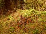
At the mine / Courtesy Aditnow forum user 'Lipsi'.

At the mine / Courtesy Aditnow forum user 'Lipsi'.
At the mine / Courtesy Aditnow forum user 'Lipsi'.
At the mine / Courtesy Aditnow forum user 'Lipsi'.
At the mine / Courtesy Aditnow forum user 'Lipsi'.
At the mine / Courtesy Aditnow forum user 'Lipsi'.
At the mine / Courtesy Aditnow forum user 'Lipsi'.
At the mine / Courtesy Aditnow forum user 'Lipsi'.
At the mine / Courtesy Aditnow forum user 'Lipsi'.
At the mine / Courtesy Aditnow forum user 'Lipsi'.
At the mine / Courtesy Aditnow forum user 'Lipsi'.
At the mine / Courtesy Aditnow forum user 'Lipsi'.

Looking roughly SW from Stounton Road (A4136), its a short walk c. 85 m straight ahead to the site of the Robin Hood Iron Pit / Google Earth Street View.


