
Robin Hood (Newport): Difference between revisions
From International Robin Hood Bibliography
mNo edit summary |
m (Text replacement - "UK Pub History" to "Pub History") |
||
| (33 intermediate revisions by 2 users not shown) | |||
| Line 1: | Line 1: | ||
__NOTOC__{{ | __NOTOC__{{PlaceNamesItemTop|Lat=50.699911|Lon=-1.286578|AdministrativeDivision=Hampshire|Vicinity=On Robin Hood Street, which connects Barton Road and Furlongs|Type=Public house|Interest=Robin Hood name|Status=Extant|Demonym=English|Riding=|GreaterLondon=|Year=1889|Aka=|Century=|Cluster1=Newport|Cluster2=Isle of Wight|Cluster3=|Image=robin-hood-newport-google-earth-street-view-1.jpg|Postcards=|ExtraCat1=|ExtraCat2=|ExtraCat3=|ExtraCat4=|ExtraCat5=|ExtraLink1=|ExtraLink2=|ExtraLink3=|ExtraLink4=|ExtraLink5=|ExtraLinkName1=|ExtraLinkName2=|ExtraLinkName3=|ExtraLinkName4=|ExtraLinkName5=|GeopointPrefix=|GeopointSuffix=|StatusSuffix=|DatePrefix=|DateSuffix=}} | ||
{{#display_map:{{#var:Coords}}~{{#replace:{{PAGENAME}}|'|'}}|width=34%}}<div class="pnMapLegend">The former Robin Hood, Newport</div> | {{#display_map:{{#var:Coords}}~{{#replace:{{PAGENAME}}|'|'}}|width=34%|enablefullscreen=yes}}<div class="pnMapLegend">The former Robin Hood, Newport</div> | ||
[[File:{{#var: | [[File:{{#var:Image}}|thumb|right|500px|The former Robin Hood, Newport / Google Earth Street View.]]<div class="no-img"> | ||
<p id="byline">By Henrik Thiil Nielsen, 2018-10-27. Revised by {{#realname:{{REVISIONUSER}}}}, {{REVISIONYEAR}}-{{REVISIONMONTH}}-{{REVISIONDAY2}}.</p | <p id="byline">By Henrik Thiil Nielsen, 2018-10-27. Revised by {{#realname:{{REVISIONUSER}}}}, {{REVISIONYEAR}}-{{REVISIONMONTH}}-{{REVISIONDAY2}}.</p> | ||
The Robin Hood on Robin Hood Street in Newport is recorded in trade directories and census records from 1889 to 1927. It closed in 2014 or later.<ref>[https:// | The Robin Hood on [[Robin Hood Street (Newport)|Robin Hood Street in Newport]] is recorded in trade directories and census records from 1889 to 1927. It closed in 2014 or later.<ref>[https://pubwiki.co.uk/IsleofWight/Newport/RobinHood.shtml Pub History: Robin Hood, Robin Hood Street, Newport, Isle of Wight, Hampshire]; [https://pubwiki.co.uk/Hampshire/Hampshire1911/Hampshire1911QR.shtml Public Houses, Inns & Taverns of Hampshire in 1911 - QR.]</ref>{{PlaceNamesItemAllusionsAndRecords}} | ||
== Gazetteers == | == Gazetteers == | ||
* Not included in {{:Dobson, Richard Barrie 1976a}}, pp. | * Not included in {{:Dobson, Richard Barrie 1976a}}, pp. 293-11. | ||
== Sources == | == Sources == | ||
* [https:// | * [https://pubwiki.co.uk/IsleofWight/Newport/RobinHood.shtml Pub History: Robin Hood, Robin Hood Street, Newport, Isle of Wight, Hampshire] | ||
** [https://pubwiki.co.uk/Hampshire/Hampshire1911/Hampshire1911QR.shtml Public Houses, Inns & Taverns of Hampshire in 1911 - QR.] | |||
== Maps == | == Maps == | ||
* 25" O.S. map ''Hampshire | * 25" O.S. map ''Hampshire & Isle of Wight'' XCV.2 (''c.'' 1865; surveyed 1862). No copy in NLS | ||
* 25" O.S. map ''Hampshire | * 25" O.S. map ''Hampshire & Isle of Wight'' XCV.2 (''c.'' 1898; rev. ''c.'' 1896). No copy in NLS | ||
* [https://maps.nls.uk/geo/explore/#zoom=18&lat=50.6996&lon=-1.2871&layers=168&b=5 25" O.S. map ''Hampshire | * [https://maps.nls.uk/geo/explore/#zoom=18&lat=50.6996&lon=-1.2871&layers=168&b=5 25" O.S. map ''Hampshire & Isle of Wight'' XCV.2 (1908; rev. 1907)] (georeferenced) | ||
* [https://maps.nls.uk/view/105990616#zoom=5&lat=4630&lon=7272&layers=BT 25" O.S. map ''Hampshire | * [https://maps.nls.uk/view/105990616#zoom=5&lat=4630&lon=7272&layers=BT 25" O.S. map ''Hampshire & Isle of Wight'' XCV.2 (1908; rev. 1907)] | ||
* [https://maps.nls.uk/view/102343206#zoom=6&lat=8877&lon=5743&layers=BT 6" O.S. map ''Hampshire | * [https://maps.nls.uk/view/102343206#zoom=6&lat=8877&lon=5743&layers=BT 6" O.S. map ''Hampshire & Isle of Wight'' XCV (1866; surveyed 1863)] | ||
* [https://maps.nls.uk/geo/explore/#zoom=18&lat=50.6998&lon=-1.2872&layers=6&b=5 6" O.S. map ''Hampshire | * [https://maps.nls.uk/geo/explore/#zoom=18&lat=50.6998&lon=-1.2872&layers=6&b=5 6" O.S. map ''Hampshire & Isle of Wight'' XCV.NW (1898; rev. 1896)] (georeferenced) | ||
* [https://maps.nls.uk/view/101442336#zoom=5&lat=4484&lon=5952&layers=BT 6" O.S. map ''Hampshire | * [https://maps.nls.uk/view/101442336#zoom=5&lat=4484&lon=5952&layers=BT 6" O.S. map ''Hampshire & Isle of Wight'' XCV.NW (1898; rev. 1896)] | ||
* [https://maps.nls.uk/view/101442333#zoom=6&lat=4624&lon=5994&layers=BT 6" O.S. map ''Hampshire | * [https://maps.nls.uk/view/101442333#zoom=6&lat=4624&lon=5994&layers=BT 6" O.S. map ''Hampshire & Isle of Wight'' XCV.NW (1909; rev. 1906-1907)] | ||
* [https://maps.nls.uk/view/101442330#zoom=6&lat=4530&lon=6080&layers=BT 6" O.S. map ''Hampshire | * [https://maps.nls.uk/view/101442330#zoom=6&lat=4530&lon=6080&layers=BT 6" O.S. map ''Hampshire & Isle of Wight'' XCV.NW (''c.'' 1947; rev. 1938).] | ||
<!--== Discussion == | <!--== Discussion ==--> | ||
== Background == | == Background == | ||
== Brief mention ==--> | * [https://www.facebook.com/Robin-Hood-Pub-839734386075373/ Facebook: Robin Hood Pub.] | ||
{{ | |||
<!--== Brief mention ==--> | |||
{{PlaceNamesItemAlsoSee}} | |||
== Notes == | == Notes == | ||
<references/> | <references/> | ||
</div> | |||
< | <div id="gallery"> | ||
{{ | {{ImageGalleryIntroduction}} | ||
<gallery widths="195px"> | <gallery widths="195px"> | ||
robin-hood-newport-google-earth-street-view-1.jpg|The former Robin Hood, Newport / Google Earth Street View. | robin-hood-newport-google-earth-street-view-1.jpg|The former Robin Hood, Newport / Google Earth Street View. | ||
| Line 35: | Line 39: | ||
robin-hood-newport-google-earth-street-view-3.jpg|The former Robin Hood, Newport / Google Earth Street View. | robin-hood-newport-google-earth-street-view-3.jpg|The former Robin Hood, Newport / Google Earth Street View. | ||
</gallery> | </gallery> | ||
</div> | |||
{{ | {{PlaceNamesItemNavigation}} | ||
Latest revision as of 15:31, 5 May 2022
| Locality | |
|---|---|
| Coordinate | 50.699911, -1.286578 |
| Adm. div. | Hampshire |
| Vicinity | On Robin Hood Street, which connects Barton Road and Furlongs |
| Type | Public house |
| Interest | Robin Hood name |
| Status | Extant |
| First Record | 1889 |
The former Robin Hood, Newport

By Henrik Thiil Nielsen, 2018-10-27. Revised by Henrik Thiil Nielsen, 2022-05-05.
The Robin Hood on Robin Hood Street in Newport is recorded in trade directories and census records from 1889 to 1927. It closed in 2014 or later.[1]
Gazetteers
- Not included in Dobson, R. B., ed.; Taylor, J., ed. Rymes of Robyn Hood: an Introduction to the English Outlaw (London, 1976), pp. 293-11.
Sources
Maps
- 25" O.S. map Hampshire & Isle of Wight XCV.2 (c. 1865; surveyed 1862). No copy in NLS
- 25" O.S. map Hampshire & Isle of Wight XCV.2 (c. 1898; rev. c. 1896). No copy in NLS
- 25" O.S. map Hampshire & Isle of Wight XCV.2 (1908; rev. 1907) (georeferenced)
- 25" O.S. map Hampshire & Isle of Wight XCV.2 (1908; rev. 1907)
- 6" O.S. map Hampshire & Isle of Wight XCV (1866; surveyed 1863)
- 6" O.S. map Hampshire & Isle of Wight XCV.NW (1898; rev. 1896) (georeferenced)
- 6" O.S. map Hampshire & Isle of Wight XCV.NW (1898; rev. 1896)
- 6" O.S. map Hampshire & Isle of Wight XCV.NW (1909; rev. 1906-1907)
- 6" O.S. map Hampshire & Isle of Wight XCV.NW (c. 1947; rev. 1938).
Background
Also see
Notes
Image gallery
Click any image to display it in the lightbox, where you can navigate between images by clicking in the right or left side of the current image.
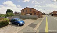
The former Robin Hood, Newport / Google Earth Street View.
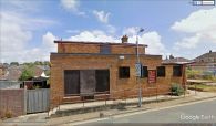
The former Robin Hood, Newport / Google Earth Street View.
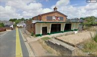
The former Robin Hood, Newport / Google Earth Street View.

