
Robin Hood (Distington): Difference between revisions
mNo edit summary |
mNo edit summary |
||
| (41 intermediate revisions by 2 users not shown) | |||
| Line 1: | Line 1: | ||
__NOTOC__ | __NOTOC__{{PlaceNamesItemTop|Lat=54.584665|Lon=-3.549601|AdministrativeDivision=Cumberland|Vicinity=''c.'' 1.8 km SSW of Distington|Type=Public house|Interest=Robin Hood name|Status=Defunct|Demonym=|Riding=|GreaterLondon=|Year=1837|Aka=|Century=|Cluster1=|Cluster2=|Cluster3=|Image=google-earth-robin-hood-p-h-distington.jpg|Postcards=|ExtraCat1=|ExtraCat2=|ExtraCat3=|ExtraCat4=|ExtraCat5=|ExtraLink1=|ExtraLink2=|ExtraLink3=|ExtraLink4=|ExtraLink5=|ExtraLinkName1=|ExtraLinkName2=|ExtraLinkName3=|ExtraLinkName4=|ExtraLinkName5=|GeopointPrefix=|GeopointSuffix=|StatusSuffix=|DatePrefix=|DateSuffix=}} | ||
{{ | {{#display_map:{{#var:Coords}}~{{#replace:{{PAGENAME}}|'|'}}|width=34%|enablefullscreen=yes}}<div class="pnMapLegend">The former Robin Hood.</div> | ||
[[File:google-earth-robin-hood-p-h-distington.jpg|thumb|right|500px|Former Robin Hood / Google Earth Street View.]]<div class="no-img"> | |||
<p id="byline">By Henrik Thiil Nielsen, 2017-02-23. Revised by {{#realname:{{REVISIONUSER}}}}, {{REVISIONYEAR}}-{{REVISIONMONTH}}-{{REVISIONDAY2}}.</p> | |||
The Robin Hood, a.k.a. the Robin Hood Inn, ''c.'' 1.8 km SSW of Distington, is indicated on a map in an 1839 book on the Lake District.<ref>{{:Ford, William 1839a}}, frontis.</ref> A much to only slightly earlier record of the pub is found in a collection of Distington deeds from 1713/14–1837 at Cumbria Archive Centre, Carlisle.<ref>[https://discovery.nationalarchives.gov.uk/details/r/a02de138-6ffd-4e81-96cc-73be644a5887 National Archives: Counterpart deeds re Stubscales, Robin Hood, Distington Mill and others not named.]</ref> In 1901, the Robin Hood was run by a William Crone.<ref>{{:Routledge, Alan W 2016a}} (ebook).</ref> It existed at least as late as 1947.<ref>[http://maps.nls.uk/view/101092414#zoom=5&lat=5634&lon=2588&layers=BT 6" O.S. map ''Cumberland'' LXI (1951; rev. 1947).]</ref> While the former pub now seems to be a family home, it is (also) listed as a small business under the name of Robin Hood Cottage.<ref> [http://www.addressesandpostcodes.co.uk/address/3UUuwTm9/robin-hood-cottage-distington-workington-ca14-5sh.html Addresses & Postcodes: Robin Hood Cottage, Distington.]</ref> | |||
{{PlaceNamesItemAllusionsAndRecords}} | |||
== Sources == | |||
* [https://discovery.nationalarchives.gov.uk/details/r/a02de138-6ffd-4e81-96cc-73be644a5887 National Archives: Counterpart deeds re Stubscales, Robin Hood, Distington Mill and others not named.] | |||
* {{:Routledge, Alan W 2016a}} (ebook). | |||
}} | |||
{{# | |||
[[File:google-earth-robin-hood-p-h-distington.jpg|thumb|right|500px| | |||
<p id="byline">By Henrik Thiil Nielsen, 2017-02-23. Revised by {{#realname:{{REVISIONUSER}}}}, {{REVISIONYEAR}}-{{REVISIONMONTH}}-{{REVISIONDAY2}}.</p | |||
The Robin Hood, a.k.a. the Robin Hood Inn, ''c.'' 1.8 km SSW of Distington, is indicated on a map in an 1839 book on the Lake District.<ref>{{:Ford, William 1839a}}, frontis.</ref> It | |||
== Gazetteers == | |||
* Not included in {{:Dobson, Richard Barrie 1976a}}, pp. 293-311. | * Not included in {{:Dobson, Richard Barrie 1976a}}, pp. 293-311. | ||
== Maps == | |||
* {{:Ford, William 1839a}}, frontis. | * {{:Ford, William 1839a}}, frontis. | ||
* [http://maps.nls.uk/view/102340869#zoom=6&lat=4727&lon=9391&layers=BT 6" O.S. map ''Cumberland'' LXI (1867; surveyed 1861-64)] | * [http://maps.nls.uk/view/102340869#zoom=6&lat=4727&lon=9391&layers=BT 6" O.S. map ''Cumberland'' LXI (1867; surveyed 1861-64)] | ||
| Line 41: | Line 21: | ||
* [http://maps.nls.uk/view/101092414#zoom=5&lat=5634&lon=2588&layers=BT 6" O.S. map ''Cumberland'' LXI (1951; rev. 1947).] | * [http://maps.nls.uk/view/101092414#zoom=5&lat=5634&lon=2588&layers=BT 6" O.S. map ''Cumberland'' LXI (1951; rev. 1947).] | ||
== Background == | |||
* [https://en.wikipedia.org/wiki/Distington Wikipedia: Distington] | * [https://en.wikipedia.org/wiki/Distington Wikipedia: Distington] | ||
* [http://www.addressesandpostcodes.co.uk/address/3UUuwTm9/robin-hood-cottage-distington-workington-ca14-5sh.html Addresses & Postcodes: Robin Hood Cottage, Distington.] | * [http://www.addressesandpostcodes.co.uk/address/3UUuwTm9/robin-hood-cottage-distington-workington-ca14-5sh.html Addresses & Postcodes: Robin Hood Cottage, Distington.] | ||
{{PlaceNamesItemAlsoSee}} | |||
== Notes == | |||
<references/> | <references/> | ||
</div> | |||
<div id="gallery"> | |||
{{ImageGalleryIntroduction}} | |||
<gallery widths="195px"> | |||
File:google-earth-robin-hood-p-h-distington.jpg|thumb|right|500px|Former Robin Hood / Google Earth Street View. | |||
File:william-ford-1839a-map.jpg|thumb|right|500px|Robin Hood indicated with a red dot on this 1839 map / {{:Ford, William 1839a}}, frontis. (Click to enlarge). | |||
File:routledge-alan-w-2016a.jpg|thumb|right|500px|Robin Hood, early 20th century / {{:Routledge, Alan W 2016a}} (ebook). | |||
</gallery> | |||
</div> | |||
{{PlaceNamesItemNavigation}} | |||
{{ | |||
Latest revision as of 05:11, 13 February 2021
| Locality | |
|---|---|
| Coordinate | 54.584665, -3.549601 |
| Adm. div. | Cumberland |
| Vicinity | c. 1.8 km SSW of Distington |
| Type | Public house |
| Interest | Robin Hood name |
| Status | Defunct |
| First Record | 1837 |

By Henrik Thiil Nielsen, 2017-02-23. Revised by Henrik Thiil Nielsen, 2021-02-13.
The Robin Hood, a.k.a. the Robin Hood Inn, c. 1.8 km SSW of Distington, is indicated on a map in an 1839 book on the Lake District.[1] A much to only slightly earlier record of the pub is found in a collection of Distington deeds from 1713/14–1837 at Cumbria Archive Centre, Carlisle.[2] In 1901, the Robin Hood was run by a William Crone.[3] It existed at least as late as 1947.[4] While the former pub now seems to be a family home, it is (also) listed as a small business under the name of Robin Hood Cottage.[5]
Sources
- National Archives: Counterpart deeds re Stubscales, Robin Hood, Distington Mill and others not named.
- Routledge, Alan W., compil. Whitehaven & Around from Old Photographs (Stroud, Gloucestershire, 2016) (ebook).
Gazetteers
- Not included in Dobson, R. B., ed.; Taylor, J., ed. Rymes of Robyn Hood: an Introduction to the English Outlaw (London, 1976), pp. 293-311.
Maps
- Ford, William. A Description of the Scenery in the Lake District, intended as a Guide to Strangers (Carlisle, 1839), frontis.
- 6" O.S. map Cumberland LXI (1867; surveyed 1861-64)
- 6" O.S. map Cumberland LXI.SE (1867; rev. 1861-64) (georeferenced)
- 6" O.S. map Cumberland LXI (1900; rev. 1898)
- 6" O.S. map Cumberland LXI (1926; rev. 1923)
- 6" O.S. map Cumberland LXI (c. 1947; rev. 1938)
- 6" O.S. map Cumberland LXI (1951; rev. 1947).
Background
Also see
Notes
- ↑ Ford, William. A Description of the Scenery in the Lake District, intended as a Guide to Strangers (Carlisle, 1839), frontis.
- ↑ National Archives: Counterpart deeds re Stubscales, Robin Hood, Distington Mill and others not named.
- ↑ Routledge, Alan W., compil. Whitehaven & Around from Old Photographs (Stroud, Gloucestershire, 2016) (ebook).
- ↑ 6" O.S. map Cumberland LXI (1951; rev. 1947).
- ↑ Addresses & Postcodes: Robin Hood Cottage, Distington.
Image gallery
Click any image to display it in the lightbox, where you can navigate between images by clicking in the right or left side of the current image.
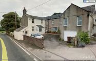
Former Robin Hood / Google Earth Street View.
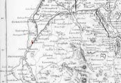
Robin Hood indicated with a red dot on this 1839 map / Ford, William. A Description of the Scenery in the Lake District, intended as a Guide to Strangers (Carlisle, 1839), frontis. (Click to enlarge).
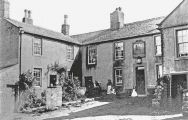
Robin Hood, early 20th century / Routledge, Alan W., compil. Whitehaven & Around from Old Photographs (Stroud, Gloucestershire, 2016) (ebook).

