
Robin Hood (Egremont)
| Locality | |
|---|---|
| Coordinate | 54.469776, -3.538887 |
| Adm. div. | Cumberland |
| Vicinity | c. 330 m E of the junction of B5345 and Queens Drive, south of Egremont |
| Type | Area |
| Interest | Robin Hood name |
| Status | Defunct? |
| First Record | 1841 |

By Henrik Thiil Nielsen, 2022-02-05. Revised by Henrik Thiil Nielsen, 2022-04-22.
A piece of land just south of Egremont, situated about 330 m east of the junction of the B5345 and Queens Drive, was known as 'Robin Hood' in 1841.
It figures with this name in the 1841 tithe award for the parish of Egremont, where its state of cultivation is listed as 'Arable & Pasture', the landowner as Thomas Nelson, and the occupier as the Revd. John Fox. Its area was 3 acres, 1 rood and 8 perches (13354.63 m2)>.[1] The Shape of the field can be seen in the detail of the tithe map in the image gallery below.
Gazetteers
- Not included in Dobson, R. B., ed.; Taylor, J., ed. Rymes of Robyn Hood: an Introduction to the English Outlaw (London, 1976), pp. 293-311.
MS sources
- 1841 tithe award for the parish of Egremont, online at the Genealogist, Piece 07, sub-piece 063, Image 146, #35 (£)
- accompanying map, at the Genealogist, Piece 07, sub-piece 063, Sub-Image 001, #146, #35 (£).
Maps
- 25" O.S. map Cumberland XXIV.15 (c. 1861; surveyed 1860)
- 6" O.S. map Cumberland XXIV.SE (1901; rev. 1899) (georeferenced)
- 25" O.S. map Cumberland XXIV.15 (1900; rev. 1899) (georeferenced)
- 25" O.S. map Cumberland XXIV.15 (1900; rev. 1899)
- 25" O.S. map Cumberland XXIV.15 (1925; rev. 1923)
- 6" O.S. map Cumberland XXIV (1868; surveyed 1861)
- 6" O.S. map Cumberland XXIV.SE (1901; rev. 1899)
- 6" O.S. map Cumberland XXIV.SE (1926; rev. 1923–24)
- 6" O.S. map Cumberland XXIV.SE (1951; rev. 1946–48).
Notes
- ↑ 1841 tithe award for the parish of Egremont, online at the Genealogist, Piece 07, sub-piece 063, Image 146, #35 (£); accompanying map, online at the Genealogist, Piece 07, sub-piece 063, Sub-Image 001, #35 (£).
Image gallery
Click any image to display it in the lightbox, where you can navigate between images by clicking in the right or left side of the current image.

This piece of land was known as 'Robin Hood' in 1841 / Google Earth Street View.
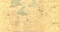
Detail of MS tithe award. Plot No. 35 was known as 'Robin Hood' in 1841 / © Crown Copyright Images reproduced by courtesy of The National Archives, London, England. www.NationalArchives.gov.uk & www.TheGenealogist.co.uk.
