
Robin Hood's Mark (Ashover): Difference between revisions
mNo edit summary |
mNo edit summary |
||
| Line 4: | Line 4: | ||
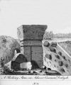
[[File:{{#var:Image}}|thumb|right|350px|Robin Hood's Mark / {{:Rooke, Hayman 1796a}}, plate facing p. 43.]] | [[File:{{#var:Image}}|thumb|right|350px|Robin Hood's Mark / {{:Rooke, Hayman 1796a}}, plate facing p. 43.]] | ||
<div class="no-img"><p id="byline">By Henrik Thiil Nielsen, 2021-06-16. Revised by {{#realname:{{REVISIONUSER}}}}, {{REVISIONYEAR}}-{{REVISIONMONTH}}-{{REVISIONDAY2}}.</p> | <div class="no-img"><p id="byline">By Henrik Thiil Nielsen, 2021-06-16. Revised by {{#realname:{{REVISIONUSER}}}}, {{REVISIONYEAR}}-{{REVISIONMONTH}}-{{REVISIONDAY2}}.</p> | ||
Robin Hood's Mark, situated ''c.'' 2 km southwest of Ashover, is first recorded in 1794. | |||
This natural stone feature is located ''c.'' 200 m south of the Turning Stone and somewhere north of Cocking Tor. Hayman Rooke, who was the first to mention Robin Hood's Mark, gave this account of it in 1794 (the figure referred to can be seen elsewhere on this page): | |||
<div class="plainquote"><p> There is in the Peak of Derbyshire a very remarkable rocking stone, called by the country people ''<keyword>Robin Hood's Mark</keyword>''; it stands on the edge of a declivity near the top of a hill on Ashover common, looking down upon Overton hall, an estate of Sir Joseph Banks, Bart. the respectable President of the Royal Society, who will undoubtedly preserve this curious Druidical monument.</p> | |||
<p> Fig. 1. plate V. represents the South view of this rocking stone, which, from its extraordinary position, evidently appears not only to have been the work of art, but to have been placed with great ingenuity; the two upper stones (a and b) have been shaped to fit exactly with the two upright stones (c and d) on which they rest; and so artfully contrived, that the lower stone (b) moves with the upper stone (a). It measures about 26 feet in circumference.</p> | |||
<p> That this is a Druidical monument formed by art, cannot, I think, be denied; we are assured that the Druids were well skilled in the art of magic, by which the superstitious Britons were led implicitly to believe in the miracles performed by these rocking stones.<ref>[https://www.themodernantiquarian.com/site/3572/turning_stone_and_robin_hoods_mark.html#inlineMap The Modern Antiquarian: Turning Stone and Robin Hoods Mark.] Rooke's italics.</ref></p></div> | |||
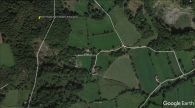
The coordinate cited in the infobox is as given at the Modern Antiquarian website.<ref>[https://www.themodernantiquarian.com/site/3572/turning_stone_and_robin_hoods_mark.html#inlineMap The Modern Antiquarian: Turning Stone and Robin Hoods Mark.]</ref> It is uncertain if this is correct. On Google Maps satellite view (see image gallery below) several outcrops are visible in the vicinity, but at the point indicated nothing except trees are to be seen. | |||
{{PlaceNamesItemAllusionsAndRecords}} | {{PlaceNamesItemAllusionsAndRecords}} | ||
| Line 9: | Line 17: | ||
* Not included in {{:Dobson, Richard Barrie 1976a}}, pp. 293-311. | * Not included in {{:Dobson, Richard Barrie 1976a}}, pp. 293-311. | ||
== Sources == | == Sources == | ||
* | * [https://www.themodernantiquarian.com/site/3572/turning_stone_and_robin_hoods_mark.html#inlineMap The Modern Antiquarian: Turning Stone and Robin Hoods Mark.] | ||
== Maps == | == Maps == | ||
* 25" map ''Derbyshire'' XXIX.16 (''c.'' 1880; surveyed ''c.'' 1875). No copy in NLS] | * 25" map ''Derbyshire'' XXIX.16 (''c.'' 1880; surveyed ''c.'' 1875). No copy in NLS] | ||
| Line 33: | Line 41: | ||
</div> | </div> | ||
{{ImageGalleryIntroduction}} | {{ImageGalleryIntroduction}} | ||
<gallery widths="195px"> | <gallery widths="195px"> | ||
rooke-hayman-1796a-plate-facing-p43.jpg|Robin Hood's Mark / {{:Rooke, Hayman 1796a}}, plate facing p. 43. | |||
</gallery | robin-hoods-mark-ashover-google-earth.jpg|Location of Robin Hood's Mark according to the Modern Antiquarian / Google Earth | ||
</gallery> | |||
{{PlaceNamesItemNavigation}} | {{PlaceNamesItemNavigation}} | ||
Revision as of 18:23, 16 June 2021
| Locality | |
|---|---|
| Coordinate | Near 53.15366, -1.487028 ? |
| Adm. div. | Derbyshire |
| Vicinity | c. 2 km SW of Ashover; c. 200 m S of the Turning Stone; north of Cocking Tor |
| Type | Natural feature |
| Interest | Robin Hood name |
| Status | Extant |
| First Record | 1794 |
| A.k.a. | Robin Hoods Mark |

By Henrik Thiil Nielsen, 2021-06-16. Revised by Henrik Thiil Nielsen, 2021-06-16.
Robin Hood's Mark, situated c. 2 km southwest of Ashover, is first recorded in 1794.
This natural stone feature is located c. 200 m south of the Turning Stone and somewhere north of Cocking Tor. Hayman Rooke, who was the first to mention Robin Hood's Mark, gave this account of it in 1794 (the figure referred to can be seen elsewhere on this page):
There is in the Peak of Derbyshire a very remarkable rocking stone, called by the country people Robin Hood's Mark; it stands on the edge of a declivity near the top of a hill on Ashover common, looking down upon Overton hall, an estate of Sir Joseph Banks, Bart. the respectable President of the Royal Society, who will undoubtedly preserve this curious Druidical monument.
Fig. 1. plate V. represents the South view of this rocking stone, which, from its extraordinary position, evidently appears not only to have been the work of art, but to have been placed with great ingenuity; the two upper stones (a and b) have been shaped to fit exactly with the two upright stones (c and d) on which they rest; and so artfully contrived, that the lower stone (b) moves with the upper stone (a). It measures about 26 feet in circumference.
That this is a Druidical monument formed by art, cannot, I think, be denied; we are assured that the Druids were well skilled in the art of magic, by which the superstitious Britons were led implicitly to believe in the miracles performed by these rocking stones.[1]
The coordinate cited in the infobox is as given at the Modern Antiquarian website.[2] It is uncertain if this is correct. On Google Maps satellite view (see image gallery below) several outcrops are visible in the vicinity, but at the point indicated nothing except trees are to be seen.
Gazetteers
- Not included in Dobson, R. B., ed.; Taylor, J., ed. Rymes of Robyn Hood: an Introduction to the English Outlaw (London, 1976), pp. 293-311.
Sources
Maps
- 25" map Derbyshire XXIX.16 (c. 1880; surveyed c. 1875). No copy in NLS]
- 25" O.S. map Derbyshire XXIX.16 (1899; rev. 1897)
- 25" O.S. map Derbyshire XXIX.16 (1922; rev. 1919)
- 25" O.S. map Ashover parish, Derbyshire (1950s) (georeferenced)
- 6" O.S. map Derbyshire XXIX.SE (1884; surveyed 1879)
- 6" O.S. map Derbyshire XXIX.SE (1899; rev. 1897–98) (georeferenced)
- 6" O.S. map Derbyshire XXIX.SE (1899; rev. 1897–98)
- 6" O.S. map Derbyshire XXIX (1923; rev. 1919–20)
- 6" O.S. map Derbyshire XXIX.SE (1923; rev. 1919)
- 6" O.S. map Derbyshire XXIX.SE (c. 1948; rev. 1938).
Also see
Notes
Image gallery
Click any image to display it in the lightbox, where you can navigate between images by clicking in the right or left side of the current image.
Robin Hood's Mark / Rooke, Hayman. 'An Account of some Druidical Remains in Derbyshire', Archaeologica: or Miscellaneous Tracts relating to Antiquity, vol. XII (1796), pp. 41-49, plate facing p. 43.
Location of Robin Hood's Mark according to the Modern Antiquarian / Google Earth
