
Robin Hood's Howl (Kirkbymoorside): Difference between revisions
mNo edit summary |
m (Text replacement - ", item #" to ", #") |
||
| (19 intermediate revisions by the same user not shown) | |||
| Line 1: | Line 1: | ||
__NOTOC__{{ | __NOTOC__{{PlaceNamesItemTop|Lat=54.273495|Lon=-0.955058|AdministrativeDivision=Yorkshire|Vicinity=''c.'' 750 m W of Kirkbymoorside|Type=Natural feature|Interest=Robin Hood name| | ||
Status=Extant|Demonym=|Riding=North|GreaterLondon=|Year=1847|Aka=|Century=|Cluster1=|Cluster2=|Cluster3=|Image=6446875_42da0a37.jpg|Postcards=|ExtraCat1=|ExtraCat2=|ExtraCat3=|ExtraCat4=|ExtraCat5=|ExtraLink1=Howe Robin (Crosby Ravensworth Fell)|ExtraLink2=Robin Hood Ball (Netheravon)|ExtraLink3=|ExtraLink4=|ExtraLink5=|ExtraLinkName1=|ExtraLinkName2=|ExtraLinkName3=|ExtraLinkName4=|ExtraLinkName5=|GeopointPrefix=|GeopointSuffix=|VicinitySuffix=|StatusSuffix=|DatePrefix=|DateSuffix=}} | Status=Extant|Demonym=|Riding=North|GreaterLondon=|Year=1847|Aka=|Century=|Cluster1=|Cluster2=|Cluster3=|Image=6446875_42da0a37.jpg|Postcards=|ExtraCat1=|ExtraCat2=|ExtraCat3=|ExtraCat4=|ExtraCat5=|ExtraLink1=Howe Robin (Crosby Ravensworth Fell)|ExtraLink2=Robin Hood Ball (Netheravon)|ExtraLink3=|ExtraLink4=|ExtraLink5=|ExtraLinkName1=|ExtraLinkName2=|ExtraLinkName3=|ExtraLinkName4=|ExtraLinkName5=|GeopointPrefix=|GeopointSuffix=|VicinitySuffix=|StatusSuffix=|DatePrefix=|DateSuffix=}} | ||
{{#display_map:{{#var:Coords}}~{{#replace:{{PAGENAME}}|'|'}}|width=34%}}<div class="pnMapLegend">{{PAGENAME}}.</div> | {{#display_map:{{#var:Coords}}~{{#replace:{{PAGENAME}}|'|'}}|width=34%|fullscreen=yes}}<div class="pnMapLegend">{{PAGENAME}}.</div> | ||
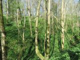
[[File:{{#var: | [[File:{{#var:Image}}|thumb|right|500px|Robin Hood's Howl / [https://m.geograph.org.uk/photo/6446875 T. Eyre, 19 Apr. 2020, Creative Commons, via Geograph.]]] | ||
<p id="byline">By Henrik Thiil Nielsen, 2020-08-28. Revised by {{#realname:{{REVISIONUSER}}}}, {{REVISIONYEAR}}-{{REVISIONMONTH}}-{{REVISIONDAY2}}.</p><div class="no-img"> | <p id="byline">By Henrik Thiil Nielsen, 2020-08-28. Revised by {{#realname:{{REVISIONUSER}}}}, {{REVISIONYEAR}}-{{REVISIONMONTH}}-{{REVISIONDAY2}}.</p><div class="no-img"> | ||
Robin Hood's Howl is a long, narrow, wooded hollow on the southern edge of the North Yorkshire Moors. First recorded in 1847, Robin Hood's Howl is situated ''c.'' 750 meters west of Kirkbymoorside, in North Yorkshire, formerly the North Riding of Yorkshire. The 'howl', which is oriented NNE–SSE is ''c.'' 1.5 km long and ''c.'' 150 m at its widest. It is entirely covered by beech trees. | Robin Hood's Howl is a long, narrow, wooded hollow on the southern edge of the North Yorkshire Moors. First recorded in 1847, Robin Hood's Howl is situated ''c.'' 750 meters west of Kirkbymoorside, in North Yorkshire, formerly the North Riding of Yorkshire. The 'howl', which is oriented NNE–SSE is ''c.'' 1.5 km long and ''c.'' 150 m at its widest. It is almost entirely covered by beech and other deciduous trees. | ||
Dobson & Taylor note that this natural feature is '[a]pparently a hole or hollow (rather than a hill)'.<ref>{{:Dobson, Richard Barrie 1976a}}, p. 306, ''s.n.'' Robin Hood's Howl.</ref> A fairly recent study of Northumberland and county Durham hill-terms lists a single example of a place-name, Howl John between the villages of Eastgate and Stanhope in Weardale, whose name includes a reflex of OE 'hōh', meaning originally "‘heel’, in the anatomical sense, and ‘heel, hill-spur’, in a transferred topographical sense".<ref>{{:Nurminen, Terhi Johanna 2012a}}, p. 169, and see p. 170. [https://www.oed.com/view/Entry/87557 ''OED'', hoe, ''n.1.'']</ref> Some 50 meters west of what is in round terms the midpoint of Robin Hood's Howl are the scheduled remains of a Bronze Age round barrow. 'Excavations have reported finding a large quantity of burnt bone together with an urn. The monument survives as a low stony mound approximately 25 metres in diameter and 0.5 metres high'.<ref>[https://www.pastscape.org.uk/hob.aspx?hob_id=58661&sort=4&search=all&criteria=Robin%20Hood%20Howl&rational=q&recordsperpage=10 Pastscape: Monument No. 58661;] its coordinate is 54.2737,-0.9568.</ref> It is conceivable that 'Robin Hood's Howl' could have originated as a name for the mound, yet if so the only moderately similar case would be that of [[Robin Hood Ball (Netheravon)]], whose name is often misapplied to a nearby prehistoric feature by modern English archaeologists. However, this mistake seems to have been first made by one of their ranks who misread the maps or perhaps did not read them at all. It seems less likely that | Dobson & Taylor note that this natural feature is '[a]pparently a hole or hollow (rather than a hill)'.<ref>{{:Dobson, Richard Barrie 1976a}}, p. 306, ''s.n.'' Robin Hood's Howl.</ref> A fairly recent study of Northumberland and county Durham hill-terms lists a single example of a place-name, Howl John between the villages of Eastgate and Stanhope in Weardale, whose name includes a reflex of OE 'hōh', meaning originally "‘heel’, in the anatomical sense, and ‘heel, hill-spur’, in a transferred topographical sense".<ref>{{:Nurminen, Terhi Johanna 2012a}}, p. 169, and see p. 170. [https://www.oed.com/view/Entry/87557 ''OED'', hoe, ''n.1.'']</ref> Some 50 meters west of what is in round terms the midpoint of Robin Hood's Howl are the scheduled remains of a Bronze Age round barrow. 'Excavations have reported finding a large quantity of burnt bone together with an urn. The monument survives as a low stony mound approximately 25 metres in diameter and 0.5 metres high'.<ref>[https://www.pastscape.org.uk/hob.aspx?hob_id=58661&sort=4&search=all&criteria=Robin%20Hood%20Howl&rational=q&recordsperpage=10 Pastscape: Monument No. 58661;] its coordinate is 54.2737,-0.9568.</ref> It is conceivable that 'Robin Hood's Howl' could have originated as a name for the mound, yet if so the only moderately similar case would be that of [[Robin Hood Ball (Netheravon)]], whose name is often misapplied to a nearby prehistoric feature by modern English archaeologists. However, this mistake seems to have been first made by one of their ranks who misread the maps or perhaps did not read them at all. It seems less likely that the name 'Robin Hood's Howl' should have been misapplied in the Ordnance Survey name book on which the early maps of the area were based, and the letter 'l' would have to be regarded as inorganic or simply a mistake, if the element 'howl' were part of the name of a mound. In view of the lay of the land it seems much more natural to take 'Howl' as a metathetic form of the noun 'hollow', which goes back to OE and ME 'holh' (also ME 'holȝ').<ref>[https://www.oed.com/view/Entry/87759 ''OED'', hollow, ''n.1.'';] also [https://quod.lib.umich.edu/m/middle-english-dictionary/dictionary/MED21018 ''MED'', holgh, ''n.'']</ref> | ||
Robin Hood's Howl first figures, as item No. 719, in the 1847 tithe award for Kirkbymoorside, where its owner/occupier is given as Lord Feversham (i.e. the third Baron Feversham), its area being 30 acres, 2 roods and 29 perches ({{ | Robin Hood's Howl first figures, as item No. 719, in the 1847 tithe award for Kirkbymoorside, where its owner/occupier is given as Lord Feversham (i.e. the third Baron Feversham), its area being 30 acres, 2 roods and 29 perches ({{AcresRoodsPerchesToM2|4|2|5}} m<sup>2</sup>), while the state of cultivation is not noted.<ref>1847 tithe award for the township of Kirkby Moorside in the Parish of Kirkby Moorside, online at the [https://www.thegenealogist.com the Genealogist], Piece 42, sub-piece 208, Image 151, #719) (£); accompanying map, online at the [https://www.thegenealogist.com the Genealogist], Piece 42, sub-piece 208, Sub-Image 001, colour (£).</ref> | ||
{{ | {{PlaceNamesItemAllusionsAndRecords}} | ||
== Gazetteers == | == Gazetteers == | ||
* {{:Dobson, Richard Barrie 1976a}}, p. 306, ''s.n.'' Robin Hood's Howl. | * {{:Dobson, Richard Barrie 1976a}}, p. 306, ''s.n.'' Robin Hood's Howl. | ||
== MS sources == | == MS sources == | ||
* 1847 tithe award for the township of Kirkby Moorside in the Parish of Kirkby Moorside, online at the [https://www.thegenealogist.com the Genealogist], | * 1847 tithe award for the township of Kirkby Moorside in the Parish of Kirkby Moorside, online at the [https://www.thegenealogist.com the Genealogist], Piece 42, sub-piece 208, Image 151, #719) (£) | ||
* accompanying map, online at the [https://www.thegenealogist.com the Genealogist], | * accompanying map, online at the [https://www.thegenealogist.com the Genealogist], Piece 42, sub-piece 208, Sub-Image 001, colour (£). | ||
== Printed sources == | == Printed sources == | ||
* {{:Ekwall, Bror Oscar Eilert 1991a}}, p. 254. | |||
* {{:Smith, Albert Hugh 1928a}}, p. 85. | * {{:Smith, Albert Hugh 1928a}}, p. 85. | ||
| Line 36: | Line 37: | ||
* --> | * --> | ||
== Background == | == Background == | ||
* [https://gavindronfield.co.uk/blog/bluebells-ramsons-robin-hoods-howl/ Gavin Dronfield photography: Bluebells and ramsons in Robin Hoods Howl] | |||
* [https://quod.lib.umich.edu/m/middle-english-dictionary/dictionary/MED21018 ''MED'', holgh, ''n.''] | * [https://quod.lib.umich.edu/m/middle-english-dictionary/dictionary/MED21018 ''MED'', holgh, ''n.''] | ||
* [https://www.megalithic.co.uk/article.php?sid=27517 Megalithic Portal: Robin Hood''s Howl] | |||
* {{:Nurminen, Terhi Johanna 2012a}}, pp. 169-70 | |||
* [https://www.oed.com/view/Entry/87557 ''OED'', hoe, ''n.1.''] | * [https://www.oed.com/view/Entry/87557 ''OED'', hoe, ''n.1.''] | ||
* [https://www.oed.com/view/Entry/87759 ''OED'', hollow, ''n.1.''] | * [https://www.oed.com/view/Entry/87759 ''OED'', hollow, ''n.1.''] | ||
* [https://www.pastscape.org.uk/hob.aspx?hob_id=58661&sort=4&search=all&criteria=Robin%20Hood%20Howl&rational=q&recordsperpage=10 Pastscape: Monument No. 58661] | * [https://www.pastscape.org.uk/hob.aspx?hob_id=58661&sort=4&search=all&criteria=Robin%20Hood%20Howl&rational=q&recordsperpage=10 Pastscape: Monument No. 58661] | ||
* [https://en.wikipedia.org/wiki/Baron_Feversham Wikipedia: Baron Feversham] | * [https://en.wikipedia.org/wiki/Baron_Feversham Wikipedia: Baron Feversham] | ||
* [https://en.wikipedia.org/wiki/Kirkbymoorside Wikipedia: Kirkbymoorside.] | * [https://en.wikipedia.org/wiki/Kirkbymoorside Wikipedia: Kirkbymoorside] | ||
* [https://www.yorkshirewalks.org/diary09/diary283.html Yorkshire Walks: Route No. 283 – Wednesday 25 February 2009: Kirkdale, Hodge Beck, Robin Hood's Howl circuit – 9km – North York Moors.] | |||
<!--== Brief mention == | <!--== Brief mention == | ||
* --> | * --> | ||
{{ | {{PlaceNamesItemAlsoSee}} | ||
== Notes == | == Notes == | ||
| Line 51: | Line 56: | ||
</div> | </div> | ||
{{ | {{ImageGalleryIntroduction}} | ||
<gallery widths="195px"> | <gallery widths="195px"> | ||
6446875_42da0a37.jpg|Robin Hood's Howl / [https://m.geograph.org.uk/photo/6446875 T. Eyre, 19 Apr. 2020, Creative Commons, via Geograph.] | 6446875_42da0a37.jpg|Robin Hood's Howl / [https://m.geograph.org.uk/photo/6446875 T. Eyre, 19 Apr. 2020, Creative Commons, via Geograph.] | ||
| Line 61: | Line 66: | ||
{{ | {{PlaceNamesItemNavigation}} | ||
Latest revision as of 19:22, 22 April 2022
| Locality | |
|---|---|
| Coordinate | 54.273495, -0.955058 |
| Adm. div. | North Riding of Yorkshire |
| Vicinity | c. 750 m W of Kirkbymoorside |
| Type | Natural feature |
| Interest | Robin Hood name |
| Status | Extant |
| First Record | 1847 |

By Henrik Thiil Nielsen, 2020-08-28. Revised by Henrik Thiil Nielsen, 2022-04-22.
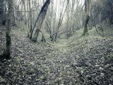
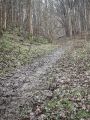
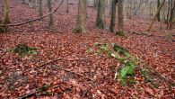
Robin Hood's Howl is a long, narrow, wooded hollow on the southern edge of the North Yorkshire Moors. First recorded in 1847, Robin Hood's Howl is situated c. 750 meters west of Kirkbymoorside, in North Yorkshire, formerly the North Riding of Yorkshire. The 'howl', which is oriented NNE–SSE is c. 1.5 km long and c. 150 m at its widest. It is almost entirely covered by beech and other deciduous trees.
Dobson & Taylor note that this natural feature is '[a]pparently a hole or hollow (rather than a hill)'.[1] A fairly recent study of Northumberland and county Durham hill-terms lists a single example of a place-name, Howl John between the villages of Eastgate and Stanhope in Weardale, whose name includes a reflex of OE 'hōh', meaning originally "‘heel’, in the anatomical sense, and ‘heel, hill-spur’, in a transferred topographical sense".[2] Some 50 meters west of what is in round terms the midpoint of Robin Hood's Howl are the scheduled remains of a Bronze Age round barrow. 'Excavations have reported finding a large quantity of burnt bone together with an urn. The monument survives as a low stony mound approximately 25 metres in diameter and 0.5 metres high'.[3] It is conceivable that 'Robin Hood's Howl' could have originated as a name for the mound, yet if so the only moderately similar case would be that of Robin Hood Ball (Netheravon), whose name is often misapplied to a nearby prehistoric feature by modern English archaeologists. However, this mistake seems to have been first made by one of their ranks who misread the maps or perhaps did not read them at all. It seems less likely that the name 'Robin Hood's Howl' should have been misapplied in the Ordnance Survey name book on which the early maps of the area were based, and the letter 'l' would have to be regarded as inorganic or simply a mistake, if the element 'howl' were part of the name of a mound. In view of the lay of the land it seems much more natural to take 'Howl' as a metathetic form of the noun 'hollow', which goes back to OE and ME 'holh' (also ME 'holȝ').[4]
Robin Hood's Howl first figures, as item No. 719, in the 1847 tithe award for Kirkbymoorside, where its owner/occupier is given as Lord Feversham (i.e. the third Baron Feversham), its area being 30 acres, 2 roods and 29 perches (18337.32 m2), while the state of cultivation is not noted.[5]
Gazetteers
- Dobson, R. B., ed.; Taylor, J., ed. Rymes of Robyn Hood: an Introduction to the English Outlaw (London, 1976), p. 306, s.n. Robin Hood's Howl.
MS sources
- 1847 tithe award for the township of Kirkby Moorside in the Parish of Kirkby Moorside, online at the the Genealogist, Piece 42, sub-piece 208, Image 151, #719) (£)
- accompanying map, online at the the Genealogist, Piece 42, sub-piece 208, Sub-Image 001, colour (£).
Printed sources
- Ekwall, Eilert, compil. The Concise Oxford Dictionary of English Place-Names. Fourth edition, reprinted (Oxford, 1991), p. 254.
- Smith, A.H. The Place-Names of the North Riding of Yorkshire (English Place-Name Society, vol. 5) (Cambridge, 1928), p. 85.
Maps
- 25" O.S. map Yorkshire XC.2 (1912; rev. 1910) (georeferenced)
- 25" O.S. map Yorkshire XC.2 (1893; surveyed 1891)
- 25" O.S. map Yorkshire XC.2 (1912; rev. 1910)
- 25" O.S. map Yorkshire XC.2 (1946; rev. 1938)
- 25" O.S. map Yorkshire LXXIV.14 (1893; surveyed 1891)
- 25" O.S. map Yorkshire LXXIV.14 (1912; rev. 1910)
- 6" O.S. map Kirkby Moorside parish (Revised: 1910; Yorkshire (1950s) Yorkshire XC.NW) (georeferenced)
- 6" O.S. map Yorkshire 74 (1856; surveyed 1848–53)
- 6" O.S. map Yorkshire LXXIV.SW (1895; surveyed 1891)
- 6" O.S. map Yorkshire LXXIV (1895; 1893). Not online
- 6" O.S. map Yorkshire LXXIV.SW (1914; rev. 1910)
- 6" O.S. map Yorkshire LXXIV.SW (1952; rev. 1950).
Background
- Gavin Dronfield photography: Bluebells and ramsons in Robin Hoods Howl
- MED, holgh, n.
- Megalithic Portal: Robin Hoods Howl
- Nurminen, Terhi Johanna. Hill-Terms in the Place-Names of Northumberland and County Durham (Doctor Phil. thesis) (Newcastle University, 2012), pp. 169-70
- OED, hoe, n.1.
- OED, hollow, n.1.
- Pastscape: Monument No. 58661
- Wikipedia: Baron Feversham
- Wikipedia: Kirkbymoorside
- Yorkshire Walks: Route No. 283 – Wednesday 25 February 2009: Kirkdale, Hodge Beck, Robin Hood's Howl circuit – 9km – North York Moors.
Also see
Notes
- ↑ Dobson, R. B., ed.; Taylor, J., ed. Rymes of Robyn Hood: an Introduction to the English Outlaw (London, 1976), p. 306, s.n. Robin Hood's Howl.
- ↑ Nurminen, Terhi Johanna. Hill-Terms in the Place-Names of Northumberland and County Durham (Doctor Phil. thesis) (Newcastle University, 2012), p. 169, and see p. 170. OED, hoe, n.1.
- ↑ Pastscape: Monument No. 58661; its coordinate is 54.2737,-0.9568.
- ↑ OED, hollow, n.1.; also MED, holgh, n.
- ↑ 1847 tithe award for the township of Kirkby Moorside in the Parish of Kirkby Moorside, online at the the Genealogist, Piece 42, sub-piece 208, Image 151, #719) (£); accompanying map, online at the the Genealogist, Piece 42, sub-piece 208, Sub-Image 001, colour (£).
Image gallery
Click any image to display it in the lightbox, where you can navigate between images by clicking in the right or left side of the current image.
Robin Hood's Howl / T. Eyre, 19 Apr. 2020, Creative Commons, via Geograph.

Limestone outcrop, Robin Hood's Howl / Mick Garratt, 2 Feb. 2020, Creative Commons, via Geograph.
Limestone outcrop, Robin Hood's Howl / Mick Garratt, 2 Feb. 2020, Creative Commons, via Geograph.
Limestone outcrop, Robin Hood's Howl / Mick Garratt, 2 Feb. 2020, Creative Commons, via Geograph.
Limestone outcrop, Robin Hood's Howl / Mick Garratt, 2 Feb. 2020, Creative Commons, via Geograph.


