
Robin Hood's Cave (Rock Cemetery, Nottingham): Difference between revisions
mNo edit summary |
m (Text replacement - "[''s.d.'']" to "[s.d.]") |
||
| (48 intermediate revisions by 2 users not shown) | |||
| Line 1: | Line 1: | ||
__NOTOC__ | __NOTOC__{{PlaceNamesItemTop|Lat=52.965540|Lon=-1.153434|AdministrativeDivision=Nottinghamshire|Vicinity=On NE edge of Rock Cemetery, Nottingham; on west side of Mansfield Road (A60)|Type=Miscellaneous|Interest=Robin Hood name|Status=Defunct|Demonym=|Riding=|GreaterLondon=|Year=1892|Aka=Robin Hoods' Mammoth Cave; Robin Hood's Caves and Stables|Century=|Cluster1=Nottingham|Cluster2=|Cluster3=|Image=Anonymous 19xxh-r.jpg|Postcards=Yes|ExtraCat1=Places named Robin Hood's Cave|ExtraCat2=|ExtraCat3=|ExtraCat4=|ExtraCat5=|ExtraLink1=|ExtraLink2=|ExtraLink3=|ExtraLink4=|ExtraLink5=|ExtraLinkName1=|ExtraLinkName2=|ExtraLinkName3=|ExtraLinkName4=|ExtraLinkName5=|GeopointPrefix=|GeopointSuffix=|StatusSuffix=|DatePrefix=|DateSuffix=}} | ||
{{ | {{#display_map:{{#var:Coords}}~{{#replace:{{PAGENAME}}|'|'}}|width=34%|enablefullscreen=yes}}<div class="pnMapLegend">Robin Hood's Caves.</div> | ||
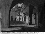
[[File:Anonymous 19xxh-r.jpg|thumb|right|500px|Anonymous. ''Robin Hood's Caves, Rock Cemetery, Nottingham''. '93/5'. [''s.n'']: [s.l.], [s.d.] Monochrome picture postcard. 87 x 135 mm.]]<div class="no-img"> | |||
<p id="byline">By Henrik Thiil Nielsen, 2017-01-13. Revised by {{#realname:{{REVISIONUSER}}}}, {{REVISIONYEAR}}-{{REVISIONMONTH}}-{{REVISIONDAY2}}.</p> | |||
Robin Hood's Cave is located at the eastern perimeter of Rock Cemetery in Nottingham, immediately west of Mansfield Road (A60). In the mid-19th century, as the area was being cleared and excavated to establish the cemetery, local clergyman George Oliver – in this very much a child of his time – was convinced that several of the caves found there, including Robin Hood's Cave, were part of an ancient druid temple.<ref>[https://nottinghamhiddenhistoryteam.wordpress.com/2014/09/22/rev-george-oliver-and-nottinghams-druid-temple/ Nottingham Hidden History Team: Rev. George Oliver and Nottingham’s Druid Temple] by Frank E. Earp.</ref> Reality has a habit of being prosaic. The caves were in fact a by-product of mining, during the 18th century and earlier, for sandstone which was ground to yield sand.<ref>{{:Waltham, Tony 1994a}}.</ref> Until the cemetery was created, the area where Robin Hood's Cave is located was known as the Ropewalk as rope was made here (see Thomas Moore's painting reproduced below). | |||
}} | |||
{{#display_map: | |||
[[File:Anonymous | |||
<p id="byline">By Henrik Thiil Nielsen, 2017-01-13. Revised by {{#realname:{{REVISIONUSER}}}}, {{REVISIONYEAR}}-{{REVISIONMONTH}}-{{REVISIONDAY2}}.</p | |||
Robin Hood's Cave is located at the eastern perimeter of Rock Cemetery in Nottingham, immediately west of Mansfield Road (A60). In the mid-19th century, as the area was being cleared and excavated to establish the cemetery, local clergyman George Oliver – in this very much a child of his | |||
In 1892, when the sand mining was long forgotten, the cave and part of the cave system with which it is connected were advertised as "Robin Hood's Mammoth Cave", "one of the grandest sights in England".<ref>{{:Waltham, Tony 1994a}}, see p. 3.</ref> At present I do not know if the cave had been connected with, or named after, Robin Hood before that date. It is noted in a recent article by a local historian that the cave "was once known as 'Robin Hood’s Cave or Stables'", and we may conclude, therefore, that the name is now defunct. I have not seen the cave referred to as Robin Hood' Stable elsewhere. As can be seen on the present page, the cave was a popular subject for photographic postcards | In 1892, when the sand mining was long forgotten, the cave and part of the cave system with which it is connected were advertised as "Robin Hood's Mammoth Cave", "one of the grandest sights in England".<ref>{{:Waltham, Tony 1994a}}, see p. 3.</ref> At present I do not know if the cave had been connected with, or named after, Robin Hood before that date. It is noted in a recent article by a local historian that the cave "was once known as 'Robin Hood’s Cave or Stables'", and we may conclude, therefore, that the name is now defunct. I have not seen the cave referred to as Robin Hood' Stable elsewhere. As can be seen on the present page, the cave was a popular subject for photographic postcards at the turn of the 20th century.<!--== Allusions == | ||
{{#ask:[[Category:Allusions (Robin Hood's Cave, Rock Cemetery, Nottingham)]]|format=embedded|embedformat= | {{#ask:[[Category:Allusions (Robin Hood's Cave, Rock Cemetery, Nottingham)]]|format=embedded|embedformat=h3|columns=1|limit=1000|sort=Utitle}}--> | ||
== Gazetteers == | |||
* Not included in {{:Dobson, Richard Barrie 1976a}}, pp. 293-311. | * Not included in {{:Dobson, Richard Barrie 1976a}}, pp. 293-311. | ||
== Sources == | |||
* {{:Waltham, Tony 1994a}}. | * {{:Waltham, Tony 1994a}}. | ||
== Maps == | |||
* [http://maps.nls.uk/view/101603127#zoom=6&lat=1452&lon=5521&layers=BT 6" O.S. map ''Nottinghamshire'' XXXVIII.SW (1885; 1878-81)] | * [http://maps.nls.uk/view/101603127#zoom=6&lat=1452&lon=5521&layers=BT 6" O.S. map ''Nottinghamshire'' XXXVIII.SW (1885; 1878-81)] | ||
* [http://maps.nls.uk/view/101603124#zoom=5&lat=1818&lon=5229&layers=BT 6" O.S. map ''Nottinghamshire'' XXXVIII.SW (1901; 1899)] | * [http://maps.nls.uk/view/101603124#zoom=5&lat=1818&lon=5229&layers=BT 6" O.S. map ''Nottinghamshire'' XXXVIII.SW (1901; 1899)] | ||
| Line 39: | Line 20: | ||
* [http://maps.nls.uk/view/101603118#zoom=5&lat=1713&lon=5202&layers=BT 6" O.S. map ''Nottinghamshire'' XXXVIII.SW (''c.'' 1947; 1938).] | * [http://maps.nls.uk/view/101603118#zoom=5&lat=1713&lon=5202&layers=BT 6" O.S. map ''Nottinghamshire'' XXXVIII.SW (''c.'' 1947; 1938).] | ||
== Background == | |||
* [https://nottinghamhiddenhistoryteam.wordpress.com/2014/09/22/rev-george-oliver-and-nottinghams-druid-temple/ Nottingham Hidden History Team: Rev. George Oliver and Nottingham’s Druid Temple] by Frank E. Earp | * [https://nottinghamhiddenhistoryteam.wordpress.com/2014/09/22/rev-george-oliver-and-nottinghams-druid-temple/ Nottingham Hidden History Team: Rev. George Oliver and Nottingham’s Druid Temple] by Frank E. Earp | ||
{{PlaceNamesItemAlsoSee}} | |||
== Notes == | |||
<references/> | <references/> | ||
</div> | |||
<div id="gallery"> | |||
{{ImageGalleryIntroduction}} | |||
<gallery widths="195px"> | |||
deering-charles-1751a-facing-p188.jpg|At or near the cave / {{:Deering, Charles 1751a}}, plate facing p. 188. | |||
Robin hoods cave church cemetery nottingham geograph.jpg|thumb|right|500px|Robin Hood's Cave / Geograph. | |||
old-ropewalk-foot-of-gallows-hill-by-thomas-moore-1848.jpg|thumb|right|500px|Painting by Thomas Moore, ''c.'' 1848, of the area known as the Ropewalk before Rock Cemetery was established / The Paul Nix Collection. | |||
Thoroton robert 1790a vol 1 tp vign.jpg|thumb|right|500px|[[Thoroton, Robert 1790a|Thoroton, Robert. ''The Antiquities of Nottinghamshire''. 2nd ed. (Nottingham, 1790), vol. I, t.-p.]] | |||
Anonymous 19xxh-r.jpg|{{:Anonymous 19xxh}} / HTN collection. | |||
Anonymous 19xxi-r.jpg|{{:Anonymous 19xxi}} / HTN collection. | |||
Anonymous 19xxj-r.jpg|{{:Anonymous 19xxj}} / HTN collection. | |||
Anonymous 19xxk-r.jpg|{{:Anonymous 19xxk}} / HTN collection. | |||
Anonymous 19xxl-r.jpg|{{:Anonymous 19xxl}} / HTN collection. | |||
Anonymous 19xxm-r.jpg|{{:Anonymous 19xxm}} / HTN collection. | |||
</gallery> | |||
</div> | |||
{{PlaceNamesItemNavigation}} | |||
{{ | |||
Latest revision as of 20:59, 22 March 2021
| Locality | |
|---|---|
| Coordinate | 52.96554, -1.153434 |
| Adm. div. | Nottinghamshire |
| Vicinity | On NE edge of Rock Cemetery, Nottingham; on west side of Mansfield Road (A60) |
| Type | Miscellaneous |
| Interest | Robin Hood name |
| Status | Defunct |
| First Record | 1892 |
| A.k.a. | Robin Hoods' Mammoth Cave; Robin Hood's Caves and Stables |

By Henrik Thiil Nielsen, 2017-01-13. Revised by Henrik Thiil Nielsen, 2021-03-22.
Robin Hood's Cave is located at the eastern perimeter of Rock Cemetery in Nottingham, immediately west of Mansfield Road (A60). In the mid-19th century, as the area was being cleared and excavated to establish the cemetery, local clergyman George Oliver – in this very much a child of his time – was convinced that several of the caves found there, including Robin Hood's Cave, were part of an ancient druid temple.[1] Reality has a habit of being prosaic. The caves were in fact a by-product of mining, during the 18th century and earlier, for sandstone which was ground to yield sand.[2] Until the cemetery was created, the area where Robin Hood's Cave is located was known as the Ropewalk as rope was made here (see Thomas Moore's painting reproduced below).
In 1892, when the sand mining was long forgotten, the cave and part of the cave system with which it is connected were advertised as "Robin Hood's Mammoth Cave", "one of the grandest sights in England".[3] At present I do not know if the cave had been connected with, or named after, Robin Hood before that date. It is noted in a recent article by a local historian that the cave "was once known as 'Robin Hood’s Cave or Stables'", and we may conclude, therefore, that the name is now defunct. I have not seen the cave referred to as Robin Hood' Stable elsewhere. As can be seen on the present page, the cave was a popular subject for photographic postcards at the turn of the 20th century.
Gazetteers
- Not included in Dobson, R. B., ed.; Taylor, J., ed. Rymes of Robyn Hood: an Introduction to the English Outlaw (London, 1976), pp. 293-311.
Sources
Maps
- 6" O.S. map Nottinghamshire XXXVIII.SW (1885; 1878-81)
- 6" O.S. map Nottinghamshire XXXVIII.SW (1901; 1899)
- 6" O.S. map Nottinghamshire XXXVIII.SW (1920; 1919)
- 6" O.S. map Nottinghamshire XXXVIII.SW (c. 1947; 1938).
Background
Also see
Notes
- ↑ Nottingham Hidden History Team: Rev. George Oliver and Nottingham’s Druid Temple by Frank E. Earp.
- ↑ Waltham, Tony. 'The Sand Mines of Nottingham', Bulletin of the Peak District Mines Historical Society, vol. 12 (1994), pp. 1-11.
- ↑ Waltham, Tony. 'The Sand Mines of Nottingham', Bulletin of the Peak District Mines Historical Society, vol. 12 (1994), pp. 1-11, see p. 3.
Image gallery
Click any image to display it in the lightbox, where you can navigate between images by clicking in the right or left side of the current image.
At or near the cave / Deering, Charles. Nottinghamia Vetus et Nova or an Historical Account of the Ancient and Present State of the Town of Nottingham (Nottingham, 1751), plate facing p. 188.
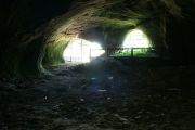
Robin Hood's Cave / Geograph.

Painting by Thomas Moore, c. 1848, of the area known as the Ropewalk before Rock Cemetery was established / The Paul Nix Collection.


