
Robin Hood's Cave (Outseats): Difference between revisions
mNo edit summary |
m (Text replacement - "ImgGalleryIntro" to "ImageGalleryIntroduction") |
||
| (18 intermediate revisions by the same user not shown) | |||
| Line 1: | Line 1: | ||
__NOTOC__{{ | __NOTOC__{{PlaceNamesItemTop|Lat=53.34879|Lon=-1.63460|AdministrativeDivision=Derbyshire|Vicinity=''c.'' 2.5 km NE of Hathersage|Type=Natural feature|Interest=Robin Hood name| | ||
Status=Extant|Demonym=|Riding=|GreaterLondon=|Year=|Aka=|Century=|Cluster1=Hathersage|Cluster2=|Cluster3=|Image=geograph-195297-by-Stephen-Horncastle.jpg|Postcards=|ExtraCat1=Places named Robin Hood's Cave|ExtraCat2=|ExtraCat3=|ExtraCat4=|ExtraCat5=|ExtraLink1=|ExtraLink2=|ExtraLink3=|ExtraLink4=|ExtraLink5=|ExtraLinkName1=|ExtraLinkName2=|ExtraLinkName3=|ExtraLinkName4=|ExtraLinkName5=|GeopointPrefix=|GeopointSuffix=|VicinitySuffix=|StatusSuffix=|DatePrefix=|DateSuffix=}} | Status=Extant|Demonym=|Riding=|GreaterLondon=|Year=1880|Aka=Robin Hoods Cave|Century=|Cluster1=Hathersage|Cluster2=|Cluster3=|Image=geograph-195297-by-Stephen-Horncastle.jpg|Postcards=|ExtraCat1=Places named Robin Hood's Cave|ExtraCat2=|ExtraCat3=|ExtraCat4=|ExtraCat5=|ExtraLink1=|ExtraLink2=|ExtraLink3=|ExtraLink4=|ExtraLink5=|ExtraLinkName1=|ExtraLinkName2=|ExtraLinkName3=|ExtraLinkName4=|ExtraLinkName5=|GeopointPrefix=|GeopointSuffix=|VicinitySuffix=|StatusSuffix=|DatePrefix=|DateSuffix=}} | ||
{{#display_map:{{#var:Coords}}~{{#replace:{{PAGENAME}}|'|'}}|width=34%}}<div class="pnMapLegend">Robin Hood's Cave, Outseats.</div> | {{#display_map:{{#var:Coords}}~{{#replace:{{PAGENAME}}|'|'}}|width=34%|fullscreen=yes}}<div class="pnMapLegend">Robin Hood's Cave, Outseats.</div> | ||
[[File:{{#var: | [[File:{{#var:Image}}|thumb|right|500px|Robin Hood's Cave, Outseats / [https://m.geograph.org.uk/photo/195297 Stephen Horncastle, 1 Sep. 2006, Creative Commons, via Geograph.]]] | ||
{{YouTube|url=https://www.youtube.com/embed/X-cg9HbbCYw|legend=Stanage Edge & Robin Hoods Cave (Backpacks and Bruises).}} | |||
<div class="no-img"><p id="byline">By Henrik Thiil Nielsen, 2020-11-29. Revised by {{#realname:{{REVISIONUSER}}}}, {{REVISIONYEAR}}-{{REVISIONMONTH}}-{{REVISIONDAY2}}.</p> | <div class="no-img"><p id="byline">By Henrik Thiil Nielsen, 2020-11-29. Revised by {{#realname:{{REVISIONUSER}}}}, {{REVISIONYEAR}}-{{REVISIONMONTH}}-{{REVISIONDAY2}}.</p> | ||
Robin Hood's Cave is situated in Stanage Edge, ''c.'' 2.5 km north-east of Hathersage. | Robin Hood's Cave is situated in Stanage Edge, ''c.'' 2.5 km north-east of Hathersage. It is nowadays much frequented by rock climbers and cave enthusiasts. | ||
{{ | |||
The earliest reference to this place-name known to IRHB occus on a 25" O.S. map of the area published in 1880, based on a survey carried out in 1879 (see Maps below). | |||
{{PlaceNamesItemAllusionsAndRecords}} | |||
== Gazetteers == | == Gazetteers == | ||
* {{:Dobson, Richard Barrie 1976a}}, p. 296 ''s.n.'' Robin Hood's Cave | * {{:Dobson, Richard Barrie 1976a}}, p. 296 ''s.n.'' Robin Hood's Cave | ||
* [https://www.megalithic.co.uk/article.php?sid=34059 Megalithic Portal: Robin Hood's Cave - Cave or Rock Shelter in England in Derbyshire.] | * [https://www.megalithic.co.uk/article.php?sid=34059 Megalithic Portal: Robin Hood's Cave - Cave or Rock Shelter in England in Derbyshire.] | ||
== Sources == | <!--== Sources == | ||
* | * --> | ||
== Maps == | == Maps == | ||
* | * [https://maps.nls.uk/view/114586574#zoom=6&lat=6575&lon=16025&layers=BT 25" O.S. map ''Derbyshire'' X.8 (1880; surveyed 1879)] | ||
* [https://maps.nls.uk/geo/explore/#zoom=17&lat=53.34937&lon=-1.63817&layers=168&b=5 25" O.S. map ''Derbyshire'' X.8 (1898; rev. 1896)] (georeferenced) | |||
* [https://maps.nls.uk/view/114586577#zoom=5&lat=7734&lon=15917&layers=BT 25" O.S. map ''Derbyshire'' X.8 (1898; rev. 1896)] | |||
* [https://maps.nls.uk/view/114586580#zoom=5&lat=5803&lon=14902&layers=BT 25" O.S. map ''Derbyshire'' X.8 (1922; rev. 1919)] | |||
* [https://maps.nls.uk/view/101600151#zoom=6&lat=2517&lon=8077&layers=BT 6" O.S. map ''Derbyshire'' X.NE (1883; surveyed 1880)] | |||
* [https://maps.nls.uk/view/100950047#zoom=6&lat=1393&lon=2658&layers=BT 6" O.S. map ''Yorkshire'' CCXCIII.SE (1894; surveyed 1891)] | |||
* [https://maps.nls.uk/view/101600148#zoom=6&lat=3098&lon=8009&layers=BT 6" O.S. map ''Derbyshire'' X.NE (1899; rev. 1896–97)] | |||
* [https://maps.nls.uk/geo/explore/#zoom=16&lat=53.34886&lon=-1.63815&layers=6&b=5 6" O.S. map ''Yorkshire'' CCXCIII.SW. SE & CCXCVIIIA.NE (1905; rev. 1901)] (georeferenced) | |||
* [https://maps.nls.uk/view/100950293#zoom=6&lat=1691&lon=3357&layers=BT 6" O.S. map ''Yorkshire'' CCXCIII.SW & SE & CCXCVIIIA.NE (1905; rev. 1901)] | |||
* [https://maps.nls.uk/view/102341289#zoom=6&lat=7408&lon=15047&layers=BT 6" O.S. map ''Derbyshire'' X (1923; rev. 1919)] | |||
* [https://maps.nls.uk/view/101600145#zoom=6&lat=2526&lon=7916&layers=BT 6" O.S. map ''Derbyshire'' X.NE (1923; rev. 1919)] | |||
* [https://maps.nls.uk/view/100950287#zoom=6&lat=2182&lon=2871&layers=BT 6" O.S. map ''Yorkshire'' CCXCIII.SW & SE & CCXCVIIIA.NE (''c.'' 1940; rev. 1920)] | |||
* [https://maps.nls.uk/view/102193458#zoom=6&lat=2427&lon=8067&layers=BT 6" O.S. map ''Derbyshire'' X.NE (''c.'' 1945; rev. 1919)] | |||
* [https://maps.nls.uk/view/101600142#zoom=6&lat=3112&lon=7421&layers=BT 6" O.S. map ''Derbyshire'' X.NE (''c.'' 1950; rev. 1948)] | |||
* [https://maps.nls.uk/view/100950284#zoom=6&lat=1960&lon=2636&layers=BT 6" O.S. map ''Yorkshire'' CCXCIII.SW & SE & CCXCVIIIA.NE (''c.'' 1950; rev. 1948)] | |||
* [https://maps.nls.uk/view/100950044#zoom=6&lat=2034&lon=2926&layers=BT 6" O.S. map ''Yorkshire'' CCXCIII.SW & CCXCIII.SE (''c.'' 1954; rev. 1948)] | |||
* [https://maps.nls.uk/view/101169737#zoom=6&lat=5406&lon=11214&layers=BT 1" O.S. map Sheet 99: ''Chapel en le Frith (Hills)'' (''Rev. New Ser.'') (1896)] | |||
* [https://maps.nls.uk/view/101169740#zoom=7&lat=5212&lon=12502&layers=BT 1" O.S. map Sheet 99: ''Chapel en le Frith (Outline)'' (''Rev. New Ser.'') (1896).] | |||
== Videos == | |||
* [https://www.youtube.com/watch?v=Sogh85jfDVU YouTube: Bertie Visits... Stanage Edge and Robin Hood's Cave (Pipes Hikes)] | |||
* [https://www.youtube.com/watch?v=X-cg9HbbCYw YouTube: Stanage Edge and Robin Hood's Cave (Backpacks and Bruises)] | |||
* [https://www.youtube.com/watch?v=RxBz145k1Qw YouTube: Entering Robin Hood's Cave, Stanage Edge (Peak Rambler)] | |||
* [https://www.youtube.com/watch?v=KiEkHHfkM4c YouTube: Leaving Robin Hood's Cave, Stanage Edge (Peak Rambler)] | |||
* [https://www.youtube.com/watch?v=m6Y3kl5z7-c YouTube: Stanage Edge – The Peak District – Millstones and near Robin Hood's Cave (Gaziano Outdoors)] | |||
* [https://www.youtube.com/watch?v=bW-iszBtdFQ YouTube: Night in Robin Hood's Cave (Michael Noon)] | |||
* [https://www.youtube.com/watch?v=JEUEfCLnAbs YouTube: Robin Hood's Cave (Stanage Edge) – Peak District Adventure (Ben Marks).] | |||
<!--== Discussion == | <!--== Discussion == | ||
* --> | * --> | ||
== Background == | == Background == | ||
* [https://snapandsaunter.com/stanage-edge-and-robin-hoods-cave-in-the-peak-district/ Snap and Saunter: Stanage Edge and Robin Hood’s Cave in the Peak District.] | |||
* [https://en.wikipedia.org/wiki/Stanage_Edge Wikipedia: Stanage Edge.] | * [https://en.wikipedia.org/wiki/Stanage_Edge Wikipedia: Stanage Edge.] | ||
<!--== Brief mention == | <!--== Brief mention == | ||
* --> | * --> | ||
{{ | {{PlaceNamesItemAlsoSee}}<!-- | ||
== Notes == | == Notes == | ||
<references/> | <references/>--> | ||
</div> | </div> | ||
{{ | {{ImageGalleryIntroduction}} | ||
<gallery widths="195px"> | <gallery widths="195px"> | ||
geograph-195297-by-Stephen-Horncastle.jpg|Robin Hood's Cave, Outseats / [https://m.geograph.org.uk/photo/195297 Stephen Horncastle, 1 Sep. 2006, Creative Commons, via Geograph.] | geograph-195297-by-Stephen-Horncastle.jpg|Robin Hood's Cave, Outseats / [https://m.geograph.org.uk/photo/195297 Stephen Horncastle, 1 Sep. 2006, Creative Commons, via Geograph.] | ||
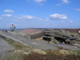
geograph-4832199-by-David-Martin.jpg|Stanage Edge near Robin Hood's Cave / [https://m.geograph.org.uk/photo/4832199 David Martin, 16 Feb. 2016, Creative Commons, via Geograph.] | geograph-4832199-by-David-Martin.jpg|Stanage Edge near Robin Hood's Cave / [https://m.geograph.org.uk/photo/4832199 David Martin, 16 Feb. 2016, Creative Commons, via Geograph.] | ||
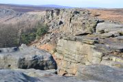
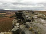
geograph-2048802-by-John-Fielding.jpg|Robin Hood's Cave Stanage Edge, looking NNW along the edge / [https://m.geograph.org.uk/photo/2048802 John Fielding, 31 Aug. 2010, Creative Commons, via Geograph.] | geograph-2048802-by-John-Fielding.jpg|Robin Hood's Cave, Stanage Edge, looking NNW along the edge / [https://m.geograph.org.uk/photo/2048802 John Fielding, 31 Aug. 2010, Creative Commons, via Geograph.] | ||
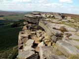
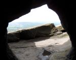
geograph-733579-by-Steve--Fareham.jpg|Robin Hood's Cave on Stanage Edge / [https://m.geograph.org.uk/photo/733579 Steve Fareham, 22 Mar. 2008, Creative Commons, via Geograph.] | geograph-733579-by-Steve--Fareham.jpg|Robin Hood's Cave on Stanage Edge / [https://m.geograph.org.uk/photo/733579 Steve Fareham, 22 Mar. 2008, Creative Commons, via Geograph.] | ||
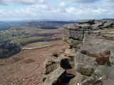
geograph-5940685-by-Chris-Holifield.jpg|Rocks above Robin Hood's Cave / [https://m.geograph.org.uk/photo/5940685 Chris Holifield, 13 Oct. 2018, Creative Commons, via Geograph.] | geograph-5940685-by-Chris-Holifield.jpg|Rocks above Robin Hood's Cave / [https://m.geograph.org.uk/photo/5940685 Chris Holifield, 13 Oct. 2018, Creative Commons, via Geograph.] | ||
| Line 40: | Line 71: | ||
{{ | {{PlaceNamesItemNavigation}} | ||
Latest revision as of 13:50, 7 January 2021
| Locality | |
|---|---|
| Coordinate | 53.34879, -1.6346 |
| Adm. div. | Derbyshire |
| Vicinity | c. 2.5 km NE of Hathersage |
| Type | Natural feature |
| Interest | Robin Hood name |
| Status | Extant |
| First Record | 1880 |
| A.k.a. | Robin Hoods Cave |

By Henrik Thiil Nielsen, 2020-11-29. Revised by Henrik Thiil Nielsen, 2021-01-07.
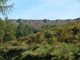
Robin Hood's Cave is situated in Stanage Edge, c. 2.5 km north-east of Hathersage. It is nowadays much frequented by rock climbers and cave enthusiasts.
The earliest reference to this place-name known to IRHB occus on a 25" O.S. map of the area published in 1880, based on a survey carried out in 1879 (see Maps below).
Gazetteers
- Dobson, R. B., ed.; Taylor, J., ed. Rymes of Robyn Hood: an Introduction to the English Outlaw (London, 1976), p. 296 s.n. Robin Hood's Cave
- Megalithic Portal: Robin Hood's Cave - Cave or Rock Shelter in England in Derbyshire.
Maps
- 25" O.S. map Derbyshire X.8 (1880; surveyed 1879)
- 25" O.S. map Derbyshire X.8 (1898; rev. 1896) (georeferenced)
- 25" O.S. map Derbyshire X.8 (1898; rev. 1896)
- 25" O.S. map Derbyshire X.8 (1922; rev. 1919)
- 6" O.S. map Derbyshire X.NE (1883; surveyed 1880)
- 6" O.S. map Yorkshire CCXCIII.SE (1894; surveyed 1891)
- 6" O.S. map Derbyshire X.NE (1899; rev. 1896–97)
- 6" O.S. map Yorkshire CCXCIII.SW. SE & CCXCVIIIA.NE (1905; rev. 1901) (georeferenced)
- 6" O.S. map Yorkshire CCXCIII.SW & SE & CCXCVIIIA.NE (1905; rev. 1901)
- 6" O.S. map Derbyshire X (1923; rev. 1919)
- 6" O.S. map Derbyshire X.NE (1923; rev. 1919)
- 6" O.S. map Yorkshire CCXCIII.SW & SE & CCXCVIIIA.NE (c. 1940; rev. 1920)
- 6" O.S. map Derbyshire X.NE (c. 1945; rev. 1919)
- 6" O.S. map Derbyshire X.NE (c. 1950; rev. 1948)
- 6" O.S. map Yorkshire CCXCIII.SW & SE & CCXCVIIIA.NE (c. 1950; rev. 1948)
- 6" O.S. map Yorkshire CCXCIII.SW & CCXCIII.SE (c. 1954; rev. 1948)
- 1" O.S. map Sheet 99: Chapel en le Frith (Hills) (Rev. New Ser.) (1896)
- 1" O.S. map Sheet 99: Chapel en le Frith (Outline) (Rev. New Ser.) (1896).
Videos
- YouTube: Bertie Visits... Stanage Edge and Robin Hood's Cave (Pipes Hikes)
- YouTube: Stanage Edge and Robin Hood's Cave (Backpacks and Bruises)
- YouTube: Entering Robin Hood's Cave, Stanage Edge (Peak Rambler)
- YouTube: Leaving Robin Hood's Cave, Stanage Edge (Peak Rambler)
- YouTube: Stanage Edge – The Peak District – Millstones and near Robin Hood's Cave (Gaziano Outdoors)
- YouTube: Night in Robin Hood's Cave (Michael Noon)
- YouTube: Robin Hood's Cave (Stanage Edge) – Peak District Adventure (Ben Marks).
Background
Also see
Image gallery
Click any image to display it in the lightbox, where you can navigate between images by clicking in the right or left side of the current image.
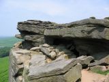
Robin Hood's Cave, Outseats / Stephen Horncastle, 1 Sep. 2006, Creative Commons, via Geograph.
Stanage Edge near Robin Hood's Cave / David Martin, 16 Feb. 2016, Creative Commons, via Geograph.
Robin Hood's Cave, Stanage Edge, looking NNW along the edge / John Fielding, 31 Aug. 2010, Creative Commons, via Geograph.
Robin Hood's Cave on Stanage Edge / Steve Fareham, 22 Mar. 2008, Creative Commons, via Geograph.
Rocks above Robin Hood's Cave / Chris Holifield, 13 Oct. 2018, Creative Commons, via Geograph.
Robin Hood's Cave, Stanage Edge / Stephen Horncastle, 7 Apr. 2007, Creative Commons, via Geograph.
Robin Hood's Cave, Outseats / Brian Deegan, 18 Feb. 2018, Creative Commons, via Geograph.
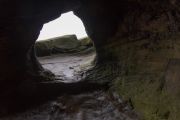
Entrance of Robin Hood's Cave, Stanage Edge / Neil Theasby, 19 May 2013, Creative Commons, via Geograph.
Stanage Edge, viewed from the road leading to North Lees Hall / 'J147', 21 July 2007, Creative Commons, via Geograph.


