
Robin Hood's Beck (Conistone): Difference between revisions
m (Text replacement - "Category:Place-Names-topics" to "Category:Place-names-topics") |
m (Text replacement - "ImgGalleryIntro" to "ImageGalleryIntroduction") |
||
| (39 intermediate revisions by 2 users not shown) | |||
| Line 1: | Line 1: | ||
__NOTOC__ | __NOTOC__{{PlaceNamesItemTop|Lat=54.08577|Lon=-2.032845|AdministrativeDivision=Yorkshire|Vicinity=Conistone, in Wharfedale|Type=Natural feature|Interest=Robin Hood name|Status=Extant|Demonym=|Riding=West|GreaterLondon=|Year=1853|Aka=|Century=|Cluster1=|Cluster2=|Cluster3=|Image=RHs Beck Conistone.jpg|Postcards=|ExtraCat1=|ExtraCat2=|ExtraCat3=|ExtraCat4=|ExtraCat5=|ExtraLink1=Robin Hood's Well (Conistone)|GeopointPrefix=|GeopointSuffix=|StatusSuffix=?|DatePrefix=|DateSuffix=}} | ||
{{ | {{#display_map:{{#var:Coords}}~{{#replace:{{PAGENAME}}|'|'}}|width=34%|enablefullscreen=yes}}<div class="pnMapLegend">Robin Hood's Beck between the road from Thresfield to Kilnsey and River<br/>Wharfe.</div> | ||
[[File:RHs Beck Conistone.jpg|thumb|right|500px|Robin Hood's Beck in Wharfedale, a trickle between the road from Thresfield to Kilnsey and River Wharfe.]]<div class="no-img"> | |||
<p id="byline">By Henrik Thiil Nielsen, 2014-08-24. Revised by {{#realname:{{REVISIONUSER}}}}, {{REVISIONYEAR}}-{{REVISIONMONTH}}-{{REVISIONDAY2}}.</p> | |||
Robin Hood's Beck is a tiny trickle running between the Thresfield–Kilnsey road and River Wharfe in Conistone, Wharfedale. A. H. Smith (1961) lists it and its source as "Robin Hood's Beck & Well" without citing any source,<ref>{{:Smith, Albert Hugh 1961a}}, vol. VI, p. 87.</ref> which tends to indicate a place-name of recent occurrence. Dobson & Taylor, as is their wont in such cases, take Smith's reference to refer to a single locality, which is not strictly true since the Beck is, of course, the little stream, while the Well is its source, just west of the road from Thresfield near the spot where the Beck runs under that road. | |||
}} | |||
{{# | |||
[[File:RHs Beck Conistone.jpg|thumb|right|500px|Robin Hood's Beck in Wharfedale, a trickle between the road from Thresfield to Kilnsey and River Wharfe.]] | |||
<p id="byline">By Henrik Thiil Nielsen, 2014-08-24. Revised by {{#realname:{{REVISIONUSER}}}}, {{REVISIONYEAR}}-{{REVISIONMONTH}}-{{REVISIONDAY2}}.</p | |||
Robin Hood's Beck is a tiny trickle running between the Thresfield–Kilnsey road and River Wharfe in Conistone, Wharfedale. A.H. Smith (1961) lists it and its source as "Robin Hood's Beck & Well" without citing any source,<ref>{{:Smith, Albert Hugh 1961a}}, vol. VI, p. 87.</ref> which tends to indicate a place-name of recent occurrence. Dobson & Taylor, as is their wont in such cases, take Smith's reference to refer to a single locality, which is not strictly true since the Beck is, of course, the little stream, while the Well is its source, just west of the road from Thresfield near the spot where the Beck runs under that road. | |||
Robin Hood's Beck is indicated on the three O.S. 6" maps of the area dating from 1853 to 1910 that are available at NLS (see Maps section below). Presumably the little stream is still known as Robin Hood's Beck. Also see [[Robin Hood's Well (Conistone)]] | Robin Hood's Beck is indicated on the three O.S. 6" maps of the area dating from 1853 to 1910 that are available at NLS (see Maps section below). Presumably the little stream is still known as Robin Hood's Beck. Also see [[Robin Hood's Well (Conistone)]]{{PlaceNamesItemAllusionsAndRecords}} | ||
{{ | == Gazetteers == | ||
* {{:Dobson, Richard Barrie 1976a}}, p. 310. | * {{:Dobson, Richard Barrie 1976a}}, p. 310. | ||
== Maps == | |||
* [http://maps.nls.uk/view/102344647#zoom=6&lat=8179&lon=2769&layers=BT 6" O.S. map Yorkshire Sheet 134 (1853, surveyed 1848-50)] (at NLS). | * [http://maps.nls.uk/view/102344647#zoom=6&lat=8179&lon=2769&layers=BT 6" O.S. map Yorkshire Sheet 134 (1853, surveyed 1848-50)] (at NLS). | ||
* [http://maps.nls.uk/view/102344644#zoom=6&lat=8182&lon=1790&layers=BT 6" O.S. map Yorkshire Sheet CXXXIV (1894, surveyed 1889-1890)] (at NLS). | * [http://maps.nls.uk/view/102344644#zoom=6&lat=8182&lon=1790&layers=BT 6" O.S. map Yorkshire Sheet CXXXIV (1894, surveyed 1889-1890)] (at NLS). | ||
* [http://maps.nls.uk/view/100944749#zoom=6&lat=4055&lon=1738&layers=BT 6" O.S. map Yorkshire Sheet CXXXIV.NW (1910, rev. 1907)] (at NLS). | * [http://maps.nls.uk/view/100944749#zoom=6&lat=4055&lon=1738&layers=BT 6" O.S. map Yorkshire Sheet CXXXIV.NW (1910, rev. 1907)] (at NLS). | ||
{{PlaceNamesItemAlsoSee}} | |||
== Notes == | |||
<references/> | |||
</div> | |||
<div id="gallery"> | |||
{{ImageGalleryIntroduction}} | |||
<gallery widths="195px"> | |||
File:RHs Beck Conistone.jpg|Robin Hood's Beck in Wharfedale, a trickle between the road from Thresfield to Kilnsey and River Wharfe. | |||
File:RHs Well and River Wharfe.jpg|River Wharfe with Robin Hood's Beck and a short curving stretch of the road from Thresfield to Kilnsey / [http://www.panoramio.com/user/1238898?with_photo_id=27092690 Panoramio user "gort".] | |||
File:RHs Beck in Conistone from road.jpg|Robin Hood's Beck and River Wharfe seen from the Thresfield to Kilnsey road / Google Earth Street View. | |||
File:RHs Beck Conistone from road.jpg|Where Robin Hood's Beck runs under the road from Thresfield to Kilnsey / Google Earth Street View. | |||
</gallery> | |||
</div> | </div> | ||
{{ | {{PlaceNamesItemNavigation}} | ||
Latest revision as of 13:50, 7 January 2021
| Locality | |
|---|---|
| Coordinate | 54.08577, -2.032845 |
| Adm. div. | West Riding of Yorkshire |
| Vicinity | Conistone, in Wharfedale |
| Type | Natural feature |
| Interest | Robin Hood name |
| Status | Extant? |
| First Record | 1853 |
Wharfe.

By Henrik Thiil Nielsen, 2014-08-24. Revised by Henrik Thiil Nielsen, 2021-01-07.
Robin Hood's Beck is a tiny trickle running between the Thresfield–Kilnsey road and River Wharfe in Conistone, Wharfedale. A. H. Smith (1961) lists it and its source as "Robin Hood's Beck & Well" without citing any source,[1] which tends to indicate a place-name of recent occurrence. Dobson & Taylor, as is their wont in such cases, take Smith's reference to refer to a single locality, which is not strictly true since the Beck is, of course, the little stream, while the Well is its source, just west of the road from Thresfield near the spot where the Beck runs under that road.
Robin Hood's Beck is indicated on the three O.S. 6" maps of the area dating from 1853 to 1910 that are available at NLS (see Maps section below). Presumably the little stream is still known as Robin Hood's Beck. Also see Robin Hood's Well (Conistone)
Gazetteers
Maps
- 6" O.S. map Yorkshire Sheet 134 (1853, surveyed 1848-50) (at NLS).
- 6" O.S. map Yorkshire Sheet CXXXIV (1894, surveyed 1889-1890) (at NLS).
- 6" O.S. map Yorkshire Sheet CXXXIV.NW (1910, rev. 1907) (at NLS).
Also see
Notes
Image gallery
Click any image to display it in the lightbox, where you can navigate between images by clicking in the right or left side of the current image.
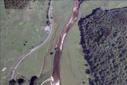
Robin Hood's Beck in Wharfedale, a trickle between the road from Thresfield to Kilnsey and River Wharfe.
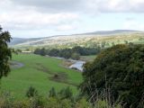
River Wharfe with Robin Hood's Beck and a short curving stretch of the road from Thresfield to Kilnsey / Panoramio user "gort".
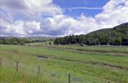
Robin Hood's Beck and River Wharfe seen from the Thresfield to Kilnsey road / Google Earth Street View.
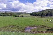
Where Robin Hood's Beck runs under the road from Thresfield to Kilnsey / Google Earth Street View.


