
Pinder of Wakefield (Grays Inn Road): Difference between revisions
m (Text replacement - "PnItemQry" to "PlaceNamesItemQuery") |
m (Text replacement - "PnItemNav" to "PlaceNamesItemNavigation") |
||
| Line 58: | Line 58: | ||
{{ | {{PlaceNamesItemNavigation}} | ||
Revision as of 00:19, 6 January 2021
| Locality | |
|---|---|
| Coordinate | 51.529015, -0.119587 |
| Adm. div. | Middlesex, now Greater London |
| Vicinity | 328 Grays Inn Road |
| Type | Public house |
| Interest | Robin Hood name |
| Status | Defunct |
| First Record | 1692 |
| A.k.a. | The Pindar of Wakefield; The Water Rats |


By Henrik Thiil Nielsen, 2018-01-15. Revised by Henrik Thiil Nielsen, 2021-01-06.
The Pinder of Wakefield, a pub on Grays Inn Road, was in existence at least as early as 1692 (see Records below). It was almost certainly in existence by 1643 and may have been established as far back as 1517, which would make it one of the oldest known public houses with Robin Hood-related names. It is now named 'The Water Rats'.
The present building, dating from 1878, was also home to an 'Old Time Music Hall' until the 1980s. The pub was frequented by Marx and Lenin during their London days. In 1986 it was acquired by the Grand Order of Water Rats[1] and its name was changed to The Water Rats.[2]
According to the well-respected London Encyclopedia, the pub was '[o]riginally built in 1517 when the landlord was George Green, one-time Pindar or pound-keeper of Wakefield, who was supposed to have had connections with Robin Hood'.[2] As the Encyclopedia is already as heavy as a dumb-bell, it is quite understandable that it does not encumber each entry with source references, but it is unfortunate in this case, for while it is quite possible it may have occurred to a publican to peddle the story that he had fought and beaten the most famous of outlaws, such an early date cannot be accepted without a reference to a reliable (near-)contemporary source. Publicans have been known to spin a yarn, and it might equally well have occurred to a slightly or much more recent incumbent – or perhaps one of his customers? – to add a little lustre to the establishment by spreading such a tale. Given the propensity of pubs with Robin Hood-related names to spawn similar place-names in their vicinity, it is likely that the Pinder of Wakefield's Fort (Clerkenwell), situated c. 750 m SE of the public house, was named after it. Since the fort was established early in the Civil War years, by 1643, the pub would have been in existence at that time. However, the earliest certain reference remains a 1692 case report in the Proceedings of the Old Bailey (see Records below). The pub is included in several maps of London dating from 1700-25 (see below). That from 1700 has a partially tree-lined garden opposite the public house.
G.W. Thornbury notes in Old and New London (1878, and perhaps also in edition of 1873) that 'The "Pinder of Wakefield" was an old public-house in the Gray's Inn Road, near Chad's Well, formerly much frequented by the wagoners of the great north road.'[3] Information on publicans gleaned from trade directories etc. from the period 1732–1944 can be found at the Pub Wiki (see Sources below).
Note with regard to Grays Inn Road, where the pub was situated, that nomenclature has shifted over time. Lockie in his Topography (editions of 1810 and 1813) refers to the entire course of Grays Inn Road as "Gray's-Inn-Lane"[4] – he has no entry under, or cross-reference from, "Grays Inn Road"; Edward Stanford's 1862-71 Library Map of London and its Suburbs labels the narrower part of the street along Grays Inn "Grays Inn Lane" but uses "Grays Inn Road" for the street north of Grays Inn where it becomes wider.[5] Nowadays the entire length is named "Grays Inn Road".
Template:PlaceNamesItemQuery
Gazetteers
- Not included in Dobson, R. B., ed.; Taylor, J., ed. Rymes of Robyn Hood: an Introduction to the English Outlaw (London, 1976), pp. 293-311.
Sources
- Weinreb, Ben; Hibbert, Christopher; Keay, Julia; Keay, John. The London Encyclopaedia. Third Edition (London, 2008), p. 642, s.n. Pindar of Wakefield
- UK Pub History: Pindar of Wakefield, 328 Grays Inn Road WC1.[6]
Maps
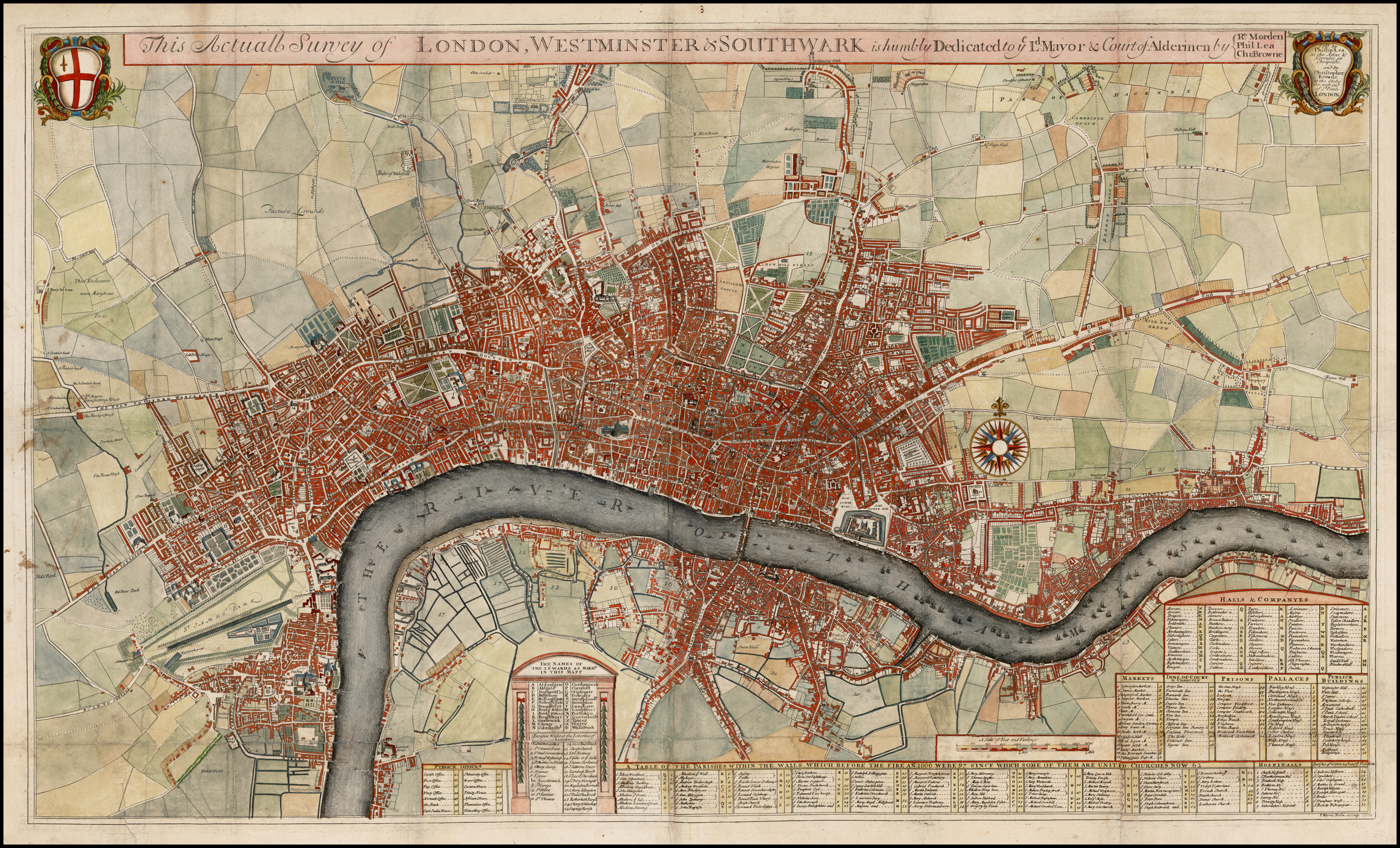
- Morden, Robert, cartog.; Lea, Philip, cartog. This Actuall Survey of London, Westminster & Southwark is Humbly Dedicated to ye Ld Mayor & Court of Aldermen (London, [1700]). See details in image gallery below
- Map in Stow, John; Strype, John. A Survey of the Cities of London and Westminster: Containing the Original, Antiquity, Increase, Modern Estate and Government of those Cities. Written at First in the Year MDXCVIII. By John Stow, Citizen and Native of London. Since Reprinted and Augmented by A.M. H.D. and other. Now Lastly, Corrected, Improved, and very much Enlarged: and the Survey and History Brought down from the Year 1633, (being near Fourscore Years since it was Last Printed) to the Present Time; by John Strype, M.A. a Native also of the Said City. Illustrated with Exact Maps of the City and Suburbs, and of All the Wards; and likewise of the Out-parishes of London and Westminster: Together with many other Fair Draughts of the more Eminent and Publick Edifices and Monuments. In Six Books. To which is Prefixed, the Life of the Author, Writ by the Editor. At the End is Added, An Appendiz of Certain Tracts, Discourses and Remarks, Concerning the State of the City of London. Together with a Perambulation, or Circuit-walk Four or Five Miles round about London, to the Parish Churches: Describing the Monuments of the Dead there Interred: with other Antiquities Observable in those Places. And Concluding with a Second Appendix, as a Supply and Review: and a Large Index of the Whole Work (London, 1720). See details below
- 25" O.S. map London XXVI (1877; surveyed 1871)
- 25" O.S. map London sheet V.6 (1916; rev. 1913)
- 6" O.S. map Middlesex XVII (1880-82; surveyed 1868-73)
- 6" O.S. map London VII.NW (1894-96; rev. 1893-94)
- 6" O.S. map London sheet K (1920; rev. 1913-14)
- 6" O.S. map London sheet K (c. 1946; rev. 1938).
Discussion
- Thornbury, Walter. Old and New London. Illustrated. A Narrative of its History, its People, and its Places (London, Paris, and New York, [1873-74]), not seen, but vol. II probably includes the mention of the pub.
- Thornbury, Walter; Walford, Edward. Old and New London: A Narrative of its History, its People, and its Places (London, Paris, and New York, [1878]), vol. II, p. 297.
Background
Notes
- ↑ Wikipedia: Grand Order of Water Rats.
- ↑ 2.0 2.1 Weinreb, Ben; Hibbert, Christopher; Keay, Julia; Keay, John. The London Encyclopaedia. Third Edition (London, 2008), p. 642, s.n. Pindar of Wakefield.
- ↑ Thornbury, Walter; Walford, Edward. Old and New London: A Narrative of its History, its People, and its Places (London, Paris, and New York, [1878]), vol. II, p. 297. Thornbury, Walter. Old and New London. Illustrated. A Narrative of its History, its People, and its Places (London, Paris, and New York, [1873-74]), not seen.
- ↑ Lockie, John, compil. Lockie's Topography of London, Giving a Concise Local Description of and Accurate Direction to Every Square, Street, Lane, Court, Dock, Wharf, Inn, Public Office, &c. in the Metropolis and its Environs (London, 1810), s.n. Gray's-Inn-Lane. Lockie, John, compil. Lockie's Topography of London, Giving a Concise Local Description of, and Accurate Direction to, Every Square, Street, Lane, Court, Dock, Wharf, Inn, Public Office, &c. in the Metropolis and its Environs. Second Edition (London, 1813), s.n. Gray's-Inn-Lane.
- ↑ Map of North West London, 1862 - 1871: Bloomsbury
- ↑ Also see the following pages at the Pub WIki: The London 1839 Public House & Publican Directory - as listed in LONDON 1839 Pigots Directory - P; London 1841 Public House & Publican Directory - P; The London 1842 Robsons Public House & Publican Directory - P; London 1869 Public House & Publican Directory - London 1869 Public House & Publican Directory - P; The London 1884 Public House & Publican Directory - P; The London 1891 Public House & Publican Directory; The London 1899 Public House & Publican Directory - P2; London publicans in 1910 - Post Office directory P1; London and Suburbs pubs in 1921 - Hughes directory listing - Pa; The London Public Houses in the 1938 Post Office Directory - Pa; The London Public Houses in the 1944 Post Office Directory - P.
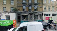
The former Pinder of Wakefield / Google Earth Street View.
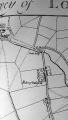
Pinder near centre; Morden, Robert; Lea, Philip. Actuall Survey of London, Westminster & Southwark (1700) / detail of map (as issued), from Philippa Glanville. London in Maps (1972), p. 113.

Pinder top centre; Strype's 1720 ed. of Stow's Survey of the Cities of London and Westminster / hand-coloured map at RareMaps.com.
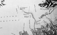
Pinder top centre; Strype's 1720 ed. of Stow's Survey of the Cities of London and Westminster / detail of map (as issued), from Philippa Glanville. London in Maps (1972), p. 116.


