
Maid Marian Pub (Chapel St Leonards): Difference between revisions
mNo edit summary |
mNo edit summary |
||
| Line 5: | Line 5: | ||
On the east side of South Road in Chapel St Leonards is a Maid Marian Pub. It is situated a few metres south of the entrance to the Golden Palm Resort, which was formerly named the [[Robin Hood Camp (Chapel St Leonards)|Robin Hood Camp.]] | On the east side of South Road in Chapel St Leonards is a Maid Marian Pub. It is situated a few metres south of the entrance to the Golden Palm Resort, which was formerly named the [[Robin Hood Camp (Chapel St Leonards)|Robin Hood Camp.]] | ||
Maid Marian is included in Google Maps Street View imagery dated 2009 (see image gallery below) and looks so young that she can hardly be several decades older than this.{{PnItemQry}} | Maid Marian is included in Google Maps Street View imagery dated 2009 (see image gallery below) and looks so young that she can hardly be several decades older than this. The pub is situated opposite Club Tropicana which was formerly the [[Maid Marion Club (Chapel St Leonards)|Maid Marion Club.]]{{PnItemQry}} | ||
== Gazetteers == | == Gazetteers == | ||
* Not included in {{:Dobson, Richard Barrie 1976a}}, pp. 293-311. | * Not included in {{:Dobson, Richard Barrie 1976a}}, pp. 293-311. | ||
Revision as of 22:01, 16 May 2019
[[File:|thumb|right|500px|Maid Marian / Google Maps Street View (2018).]]
By Henrik Thiil Nielsen, 2019-05-16. Revised by Henrik Thiil Nielsen, 2019-05-16.
On the east side of South Road in Chapel St Leonards is a Maid Marian Pub. It is situated a few metres south of the entrance to the Golden Palm Resort, which was formerly named the Robin Hood Camp.
Maid Marian is included in Google Maps Street View imagery dated 2009 (see image gallery below) and looks so young that she can hardly be several decades older than this. The pub is situated opposite Club Tropicana which was formerly the Maid Marion Club.Template:PnItemQry
Gazetteers
- Not included in Dobson, R. B., ed.; Taylor, J., ed. Rymes of Robyn Hood: an Introduction to the English Outlaw (London, 1976), pp. 293-311.
Maps
Pub not labelled or indicated on maps.
- 25" O.S. map Lincolnshire LXXVI.7 (c. 1889; surveyed c. 1888). No Copy in NLS
- 25" O.S. map Lincolnshire LXXVI.7 (1906; rev. 1905) (georeferenced)
- 25" O.S. map Lincolnshire LXXVI.7 (1906; rev. 1905)
- 6" O.S. map Lincolnshire LXXVI.NE (1907; rev. 1905) (georeferenced)
- 6" O.S. map Lincolnshire LXXVI.NE (1888; surveyed 1888)
- 6" O.S. map Lincolnshire LXXVI.NE (1907; rev. 1905)
- 6" O.S. map Lincolnshire LXXVI.NE (c. 1948; rev. 1938)
- 6" O.S. map Lincolnshire LXXVI.NE (1951; rev. 1946).
Background
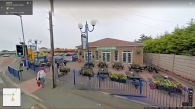
Maid Marian in 2009 / Google Maps Street View.
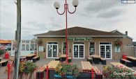
Maid Marian in 2018 / Google Maps Street View.

