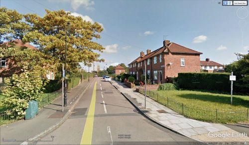
Littlejohn Road (Ealing): Difference between revisions
From International Robin Hood Bibliography
m (Text replacement - "PlaceNamesItemQuery" to "PlaceNamesItemAllusionsAndRecords") |
m (Text replacement - "No Copy in NLS" to "No copy in NLS") |
||
| Line 12: | Line 12: | ||
== Maps == | == Maps == | ||
* {{:Bartholomew, John 1968a}}, 61M | * {{:Bartholomew, John 1968a}}, 61M | ||
* 25" O.S. map ''Middlesex'' XV.12 (''c.'' 1866; surveyed 1863-1864). No | * 25" O.S. map ''Middlesex'' XV.12 (''c.'' 1866; surveyed 1863-1864). No copy in NLS | ||
* [http://maps.nls.uk/geo/explore/#zoom=17&lat=51.5193&lon=-0.3359&layers=168&b=5 25" O.S. map ''London'' (Edition of 1894-96) LVI (1896; rev. 1891-94)] (georeferenced) | * [http://maps.nls.uk/geo/explore/#zoom=17&lat=51.5193&lon=-0.3359&layers=168&b=5 25" O.S. map ''London'' (Edition of 1894-96) LVI (1896; rev. 1891-94)] (georeferenced) | ||
* [https://maps.nls.uk/view/101919795#zoom=4&lat=10042&lon=1667&layers=BT 25" O.S. map ''London (1896; rev. 1891-94)] | * [https://maps.nls.uk/view/101919795#zoom=4&lat=10042&lon=1667&layers=BT 25" O.S. map ''London (1896; rev. 1891-94)] | ||
Latest revision as of 01:02, 13 February 2021
| Locality | |
|---|---|
| Coordinate | 51.518947, -0.334719 |
| Adm. div. | Middlesex, now Greater London |
| Vicinity | Side street on north side of Homefarm Road |
| Type | Thoroughfare |
| Interest | Robin Hood name |
| Status | Extant |
| First Record | 1968 |
Littlejohn Road (Ealing).
By Henrik Thiil Nielsen, 2018-01-13. Revised by Henrik Thiil Nielsen, 2021-02-13.
Littlejohn Road is a residential street in Ealing, formerly part of Middlesex, now Greater London.
The road is not included on any of the 19th century or pre-WWII O.S. maps listed below. The earliest reference I have so far is the 1968 edition of Bartholomew's Reference Atlas of Greater London" (see Maps below).
Gazetteers
- Not included in Dobson, R. B., ed.; Taylor, J., ed. Rymes of Robyn Hood: an Introduction to the English Outlaw (London, 1976), pp. 293-311.
Maps
- John Bartholomew & Son Ltd. Bartholomew's Reference Atlas of Greater London, Covering the Whole Metropolitan Police Area, with Larger Scale Maps For Central London and Index For Quick Location of Over 62,000 Names (Edinburgh, 1968), 61M
- 25" O.S. map Middlesex XV.12 (c. 1866; surveyed 1863-1864). No copy in NLS
- 25" O.S. map London (Edition of 1894-96) LVI (1896; rev. 1891-94) (georeferenced)
- 25" O.S. map London (1896; rev. 1891-94)
- 25" O.S. map Middlesex XV.12 (1915; rev. 1913)
- 25" O.S. map Middlesex XV.12 (1934; rev. 1932)
- 25" O.S. map Middlesex XV.12 (1937; rev. 1934)
- 6" O.S. map Middlesex XV (1868; surveyed 1864-65)
- 6" O.S. map Surrey I (1871; surveyed 1867)
- 6" O.S. map London V.SE (1894-96; rev. 1891-94)
- 6" O.S. map London V.SE (1894-96; rev. 1891-94) (georeferenced)
- 6" O.S. map London Sheet I (1920; rev. 1912-13)
- 6" O.S. map Middlesex XV.SE (1920; rev. 1913)
- 6" O.S. map Middlesex XV.SE (1940; rev. 1934)
- 6" O.S. map Middlesex XV.SE (1946; rev. 1938).
Also see

