
Little John Croft (Antrobus): Difference between revisions
(Created page with "__NOTOC__{{PlaceNamesItemTop|Lat=53.322458|Lon=-2.541960|AdministrativeDivision=Cheshire|Vicinity=NW side of Reed Lane, ''c.'' 450 m NE of Fogg's Lane, immediately ESE of the...") |
m (Text replacement - ", piece" to ", Piece") |
||
| (3 intermediate revisions by the same user not shown) | |||
| Line 3: | Line 3: | ||
{{#display_map:{{#var:Coords}}~{{#replace:{{PAGENAME}}|'|'}}|width=34%|fullscreen=yes}}<div class="pnMapLegend">(The former?) Little John Croft.</div> | {{#display_map:{{#var:Coords}}~{{#replace:{{PAGENAME}}|'|'}}|width=34%|fullscreen=yes}}<div class="pnMapLegend">(The former?) Little John Croft.</div> | ||
[[File:{{#var:Image}}|thumb|right|500px|A field here was known as 'Little John Croft' in the mid-19th century / Google Earth Street View.]] | [[File:{{#var:Image}}|thumb|right|500px|A field here was known as 'Little John Croft' in the mid-19th century / Google Earth Street View.]] | ||
<div class="no-img"><p id="byline">By | <div class="no-img"><p id="byline">By Henrik Thiil Nielsen, 2021-03-01. Revised by {{#realname:{{REVISIONUSER}}}}, {{REVISIONYEAR}}-{{REVISIONMONTH}}-{{REVISIONDAY2}}.</p> | ||
A potato field on the northwest side of Reed Lane, ''c.'' 450 metres northeast of Fogg's Lane, immediately east-southeast of the golf course in Antrobus, was known as 'Little John Croft' in the mid-19th century. | A potato field on the northwest side of Reed Lane, ''c.'' 450 metres northeast of Fogg's Lane, immediately east-southeast of the golf course in Antrobus, was known as 'Little John Croft' in the mid-19th century. | ||
The field figures under this name in the 1840 tithe award for the township of Antrobus in the parish of Budworth, with Sir Edmund Antrobus, Bart., as landowner, William Vernon as occupier, 'Potatoes' for 'State of Cultivation' and an area of 2 acres and 27 perches ({{AcresRoodsPerchesToM2|2|0|27}} m<sup>2</sup>).<ref>1844 tithe award for the township of Antrobus in the parish of Budworth, online at the [https://www.thegenealogist.com Genealogist], | The field figures under this name in the 1840 tithe award for the township of Antrobus in the parish of Budworth, with Sir Edmund Antrobus, Bart., as landowner, William Vernon as occupier, 'Potatoes' for 'State of Cultivation' and an area of 2 acres and 27 perches ({{AcresRoodsPerchesToM2|2|0|27}} m<sup>2</sup>).<ref>1844 tithe award for the township of Antrobus in the parish of Budworth, online at the [https://www.thegenealogist.com Genealogist], Piece 05, sub-piece 016, Image 007, #70 (£); accompanying map, online at the [https://www.thegenealogist.com Genealogist], Piece 05, sub-piece 016, Sub-Image 001, #70 (£).</ref>Extending about 200 metres west-northwest from Reed Lane, the roughly rectangular plot was no more than ''c.'' 35 wide at the end near the road and about 50 metres wide at the opposite end. It is indicated in maroon in the adapted map detail included in the image gallery below. | ||
{{PlaceNamesItemAllusionsAndRecords}} | {{PlaceNamesItemAllusionsAndRecords}} | ||
== Gazetteers == | == Gazetteers == | ||
| Line 12: | Line 12: | ||
== MS sources == | == MS sources == | ||
* 1844 tithe award for the township of Antrobus in the parish of Budworth, online at the [https://www.thegenealogist.com Genealogist], | * 1844 tithe award for the township of Antrobus in the parish of Budworth, online at the [https://www.thegenealogist.com Genealogist], Piece 05, sub-piece 016, Image 007, #70 (£) | ||
* accompanying map, online at the [https://www.thegenealogist.com Genealogist], | * accompanying map, online at the [https://www.thegenealogist.com Genealogist], Piece 05, sub-piece 016, Sub-Image 001, #70 (£). | ||
== Maps == | == Maps == | ||
Latest revision as of 19:02, 22 April 2022
| Locality | |
|---|---|
| Coordinate | 53.322458, -2.54196 |
| Adm. div. | Cheshire |
| Vicinity | NW side of Reed Lane, c. 450 m NE of Fogg's Lane, immediately ESE of the golf course in Antrobus |
| Type | Area |
| Interest | Robin Hood name |
| Status | Defunct? |
| First Record | 1844 |

By Henrik Thiil Nielsen, 2021-03-01. Revised by Henrik Thiil Nielsen, 2022-04-22.
A potato field on the northwest side of Reed Lane, c. 450 metres northeast of Fogg's Lane, immediately east-southeast of the golf course in Antrobus, was known as 'Little John Croft' in the mid-19th century.
The field figures under this name in the 1840 tithe award for the township of Antrobus in the parish of Budworth, with Sir Edmund Antrobus, Bart., as landowner, William Vernon as occupier, 'Potatoes' for 'State of Cultivation' and an area of 2 acres and 27 perches (8776.62 m2).[1]Extending about 200 metres west-northwest from Reed Lane, the roughly rectangular plot was no more than c. 35 wide at the end near the road and about 50 metres wide at the opposite end. It is indicated in maroon in the adapted map detail included in the image gallery below.
Gazetteers
- Not included in Dobson, R. B., ed.; Taylor, J., ed. Rymes of Robyn Hood: an Introduction to the English Outlaw (London, 1976), pp. 293-311.
MS sources
- 1844 tithe award for the township of Antrobus in the parish of Budworth, online at the Genealogist, Piece 05, sub-piece 016, Image 007, #70 (£)
- accompanying map, online at the Genealogist, Piece 05, sub-piece 016, Sub-Image 001, #70 (£).
Maps
- 25" O.S. map Cheshire XXVI.5 (c. 1877; surveyed c. 1874). No copy in NLS
- 25" O.S. map Cheshire XXVI.5 (1898; rev. 1897) (georeferenced)
- 25" O.S. map Cheshire XXVI.5 (1898; rev. 1897)
- 25" O.S. map Cheshire XXVI.5 (1910; rev. 1908)
- 6" O.S. map Cheshire XXVI (1881; surveyed 1876–77)
- 6" O.S. map Cheshire XXVI.NW (1899; rev. 1897) (georeferenced)
- 6" O.S. map Cheshire XXVI.NW (1899; rev. 1897)
- 6" O.S. map Cheshire XXVI.NW (1910; rev. 1907–08).
Background
Notes
- ↑ 1844 tithe award for the township of Antrobus in the parish of Budworth, online at the Genealogist, Piece 05, sub-piece 016, Image 007, #70 (£); accompanying map, online at the Genealogist, Piece 05, sub-piece 016, Sub-Image 001, #70 (£).
Image gallery
Click any image to display it in the lightbox, where you can navigate between images by clicking in the right or left side of the current image.
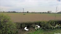
A field here was known as 'Little John Croft' in the mid-19th century / Google Earth Street View.
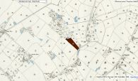
Robin Hood Croft indicated in maroon / Detail of 25" O.S. map Cheshire XXVI.5 (1898; rev. 1897) (georeferenced); reprod. with perm. of NLS; under Creative Commons Attrib. (CC-BY) license; adapt. Henrik Thiil Nielsen.
