Little John (Tibshelf): Difference between revisions
From International Robin Hood Bibliography
m (Text replacement - ", image" to ", Image") |
m (Text replacement - ", sub-image" to ", Sub-Image") |
||
| Line 3: | Line 3: | ||
[[File:{{#var:Image}}|thumb|right|500px|Little John / Google Earth.]]<div class="no-img"> | [[File:{{#var:Image}}|thumb|right|500px|Little John / Google Earth.]]<div class="no-img"> | ||
<p id="byline">By Henrik Thiil Nielsen, 2016-08-10. Revised by {{#realname:{{REVISIONUSER}}}}, {{REVISIONYEAR}}-{{REVISIONMONTH}}-{{REVISIONDAY2}}.</p> | <p id="byline">By Henrik Thiil Nielsen, 2016-08-10. Revised by {{#realname:{{REVISIONUSER}}}}, {{REVISIONYEAR}}-{{REVISIONMONTH}}-{{REVISIONDAY2}}.</p> | ||
According to an 1844 tithe award, a field in the township of Tibshelf was named Little John. The name is also found on a second tithe award schedule that was drawn up in 1926. In 1844 the field was owned by the Governors of the Hospital of St Thomas, its occupier being a John Tagg. It was characterized as a grass area, measuring 2 acres and 9 perches ({{AcresRoodsPerchesToM2|2|0|9}} m<sup>2</sup>).<ref>{{:Cameron, Kenneth 1959a}}, pt. II, p. 315. Cameron dates the tithe award 1846, but the first tithe award schedule has the date 1844, the map being dated 1846. See [https://www.thegenealogist.co.uk/image_viewer/?imagego=yVaqkz_Qlg-fGyJpQu891TJ9ziRQSuSdqWR3Luzp6829gR0jOOqRSBdHRv3diPgXeg-WwgPfLqnx8BIW0sqY0qeDwm4x0UEZo3AooBctGwI43pbC1gvpOBystAMOOndO Genealogist: piece 8, sub-piece 210, Image 038] (first schedule); [https://www.thegenealogist.co.uk/image_viewer/?imagego=5QIH2T2WPVLBR_rz7g5lyEcKvVpX0gSQ9AVPicWgEFcAmpBB6OsY3LdmDlX6wOV3iHalwvLr9kQpj-zZLXLCDN8ITY7MtewB9FPTC0onZTeR_SOqsfsTFa7Y41syC2id&o=%5B%5B%22zc%22%2C6833%2C13451%5D%2C%5B%22dg%22%2C%5B%5B6833%2C13451%5D%5D%2C%22Landowner%3A+Duke+Of+Devonshire%3Cbr%3EOccupier%3A+Edward++Sampson+Junior%22%5D%5D&id=57658251 Genealogist: piece 8, sub-piece 210, | According to an 1844 tithe award, a field in the township of Tibshelf was named Little John. The name is also found on a second tithe award schedule that was drawn up in 1926. In 1844 the field was owned by the Governors of the Hospital of St Thomas, its occupier being a John Tagg. It was characterized as a grass area, measuring 2 acres and 9 perches ({{AcresRoodsPerchesToM2|2|0|9}} m<sup>2</sup>).<ref>{{:Cameron, Kenneth 1959a}}, pt. II, p. 315. Cameron dates the tithe award 1846, but the first tithe award schedule has the date 1844, the map being dated 1846. See [https://www.thegenealogist.co.uk/image_viewer/?imagego=yVaqkz_Qlg-fGyJpQu891TJ9ziRQSuSdqWR3Luzp6829gR0jOOqRSBdHRv3diPgXeg-WwgPfLqnx8BIW0sqY0qeDwm4x0UEZo3AooBctGwI43pbC1gvpOBystAMOOndO Genealogist: piece 8, sub-piece 210, Image 038] (first schedule); [https://www.thegenealogist.co.uk/image_viewer/?imagego=5QIH2T2WPVLBR_rz7g5lyEcKvVpX0gSQ9AVPicWgEFcAmpBB6OsY3LdmDlX6wOV3iHalwvLr9kQpj-zZLXLCDN8ITY7MtewB9FPTC0onZTeR_SOqsfsTFa7Y41syC2id&o=%5B%5B%22zc%22%2C6833%2C13451%5D%2C%5B%22dg%22%2C%5B%5B6833%2C13451%5D%5D%2C%22Landowner%3A+Duke+Of+Devonshire%3Cbr%3EOccupier%3A+Edward++Sampson+Junior%22%5D%5D&id=57658251 Genealogist: piece 8, sub-piece 210, Sub-Image 001]; | ||
[https://www.thegenealogist.co.uk/image_viewer/?imagego=yVaqkz_Qlg-fGyJpQu891TJ9ziRQSuSdqWR3Luzp6811mdjNvPxotvLvyYHbsb-9mSHL8NdAJ_uVgT2pDUMnG6eDwm4x0UEZo3AooBctGwI43pbC1gvpOBystAMOOndO Genealogist: piece 8, sub-piece 210, Image 080] (second schedule).</ref> The field is somewhat smaller than the others in the immediate vicinity. Perhaps it was this circumstance that suggested the name. | [https://www.thegenealogist.co.uk/image_viewer/?imagego=yVaqkz_Qlg-fGyJpQu891TJ9ziRQSuSdqWR3Luzp6811mdjNvPxotvLvyYHbsb-9mSHL8NdAJ_uVgT2pDUMnG6eDwm4x0UEZo3AooBctGwI43pbC1gvpOBystAMOOndO Genealogist: piece 8, sub-piece 210, Image 080] (second schedule).</ref> The field is somewhat smaller than the others in the immediate vicinity. Perhaps it was this circumstance that suggested the name. | ||
| Line 12: | Line 12: | ||
== MS sources == | == MS sources == | ||
* [https://www.thegenealogist.co.uk/image_viewer/?imagego=yVaqkz_Qlg-fGyJpQu891TJ9ziRQSuSdqWR3Luzp6829gR0jOOqRSBdHRv3diPgXeg-WwgPfLqnx8BIW0sqY0qeDwm4x0UEZo3AooBctGwI43pbC1gvpOBystAMOOndO Genealogist: piece 8, sub-piece 210, Image 038] (first schedule) | * [https://www.thegenealogist.co.uk/image_viewer/?imagego=yVaqkz_Qlg-fGyJpQu891TJ9ziRQSuSdqWR3Luzp6829gR0jOOqRSBdHRv3diPgXeg-WwgPfLqnx8BIW0sqY0qeDwm4x0UEZo3AooBctGwI43pbC1gvpOBystAMOOndO Genealogist: piece 8, sub-piece 210, Image 038] (first schedule) | ||
* [https://www.thegenealogist.co.uk/image_viewer/?imagego=5QIH2T2WPVLBR_rz7g5lyEcKvVpX0gSQ9AVPicWgEFcAmpBB6OsY3LdmDlX6wOV3iHalwvLr9kQpj-zZLXLCDN8ITY7MtewB9FPTC0onZTeR_SOqsfsTFa7Y41syC2id&o=%5B%5B%22zc%22%2C6833%2C13451%5D%2C%5B%22dg%22%2C%5B%5B6833%2C13451%5D%5D%2C%22Landowner%3A+Duke+Of+Devonshire%3Cbr%3EOccupier%3A+Edward++Sampson+Junior%22%5D%5D&id=57658251 Genealogist: piece 8, sub-piece 210, | * [https://www.thegenealogist.co.uk/image_viewer/?imagego=5QIH2T2WPVLBR_rz7g5lyEcKvVpX0gSQ9AVPicWgEFcAmpBB6OsY3LdmDlX6wOV3iHalwvLr9kQpj-zZLXLCDN8ITY7MtewB9FPTC0onZTeR_SOqsfsTFa7Y41syC2id&o=%5B%5B%22zc%22%2C6833%2C13451%5D%2C%5B%22dg%22%2C%5B%5B6833%2C13451%5D%5D%2C%22Landowner%3A+Duke+Of+Devonshire%3Cbr%3EOccupier%3A+Edward++Sampson+Junior%22%5D%5D&id=57658251 Genealogist: piece 8, sub-piece 210, Sub-Image 001] | ||
* [https://www.thegenealogist.co.uk/image_viewer/?imagego=yVaqkz_Qlg-fGyJpQu891TJ9ziRQSuSdqWR3Luzp6811mdjNvPxotvLvyYHbsb-9mSHL8NdAJ_uVgT2pDUMnG6eDwm4x0UEZo3AooBctGwI43pbC1gvpOBystAMOOndO Genealogist: piece 8, sub-piece 210, Image 080] (second schedule). | * [https://www.thegenealogist.co.uk/image_viewer/?imagego=yVaqkz_Qlg-fGyJpQu891TJ9ziRQSuSdqWR3Luzp6811mdjNvPxotvLvyYHbsb-9mSHL8NdAJ_uVgT2pDUMnG6eDwm4x0UEZo3AooBctGwI43pbC1gvpOBystAMOOndO Genealogist: piece 8, sub-piece 210, Image 080] (second schedule). | ||
Latest revision as of 18:47, 22 April 2022
| Locality | |
|---|---|
| Coordinate | 53.127542, -1.361254 |
| Adm. div. | Derbyshire |
| Vicinity | Near Tibshelf |
| Type | Area |
| Interest | Robin Hood name |
| Status | Defunct? |
| First Record | 1844 |
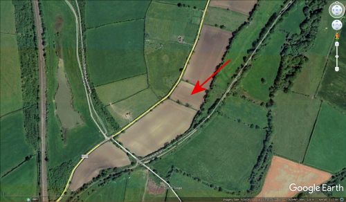
The little field named Little John.
By Henrik Thiil Nielsen, 2016-08-10. Revised by Henrik Thiil Nielsen, 2022-04-22.
According to an 1844 tithe award, a field in the township of Tibshelf was named Little John. The name is also found on a second tithe award schedule that was drawn up in 1926. In 1844 the field was owned by the Governors of the Hospital of St Thomas, its occupier being a John Tagg. It was characterized as a grass area, measuring 2 acres and 9 perches (8321.35 m2).[1] The field is somewhat smaller than the others in the immediate vicinity. Perhaps it was this circumstance that suggested the name.
IRHB does not know if the field still answers to the name of 'Little John'.
Gazetteers
- Not included in Dobson, R. B., ed.; Taylor, J., ed. Rymes of Robyn Hood: an Introduction to the English Outlaw (London, 1976), pp. 293-311.
MS sources
- Genealogist: piece 8, sub-piece 210, Image 038 (first schedule)
- Genealogist: piece 8, sub-piece 210, Sub-Image 001
- Genealogist: piece 8, sub-piece 210, Image 080 (second schedule).
Printed sources
- Cameron, Kenneth. The Place-Names of Derbyshire (English Place-Name Society, vols. XXVII-XXIX) (Cambridge, 1959), pt. II, p. 315.
Maps
- 6" O.S. map Derbyshire XXXV.NE (1884; rev. 1876-79)
- 6" O.S. map Derbyshire XXXV.NE (1900; rev. 1898)
- 6" O.S. map Derbyshire XXXV (1921; rev. 1913)
- 6" O.S. map Derbyshire XXXV.NE (1921; rev. 1913).
Also see
Notes
- ↑ Cameron, Kenneth. The Place-Names of Derbyshire (English Place-Name Society, vols. XXVII-XXIX) (Cambridge, 1959), pt. II, p. 315. Cameron dates the tithe award 1846, but the first tithe award schedule has the date 1844, the map being dated 1846. See Genealogist: piece 8, sub-piece 210, Image 038 (first schedule); Genealogist: piece 8, sub-piece 210, Sub-Image 001; Genealogist: piece 8, sub-piece 210, Image 080 (second schedule).

