Little John's Well (Outseats, Hathersage): Difference between revisions
From International Robin Hood Bibliography
m (Text replacement - "<!-- {{ImgGalleryIntro}} <gallery widths="195px"> FOR EACH IMAGE: File:_FILENAME.jpg|_LEGEND / [_URL _PHOTOGRAPHER, _DAY _MON. _YEAR, Creative Commons.] </gallery>-->" to "") |
m (Text replacement - "PlaceNamesItemQuery" to "PlaceNamesItemAllusionsAndRecords") |
||
| (33 intermediate revisions by the same user not shown) | |||
| Line 1: | Line 1: | ||
__NOTOC__{{ | __NOTOC__{{PlaceNamesItemTop|Lat=53.3113|Lon=-1.6022|AdministrativeDivision=Derbyshire|Vicinity=''c.'' 475 m. SSE of Longshaw Lodge; ''c.'' 3 km ESE of Hathersage|Type=Natural feature|Interest=Robin Hood name|Status=Extant|Demonym=|Riding=|GreaterLondon=|Year=1882|Aka=|Century=|Cluster1=Outseats|Cluster2=Hathersage|Cluster3=|Image=little-johns-well-outseats-roger-temple-geograph.jpg|Postcards=|ExtraCat1=Places named Little John's Well|ExtraCat2=Places named after Little John|ExtraCat3=|ExtraCat4=|ExtraCat5=|ExtraLink1=|ExtraLink2=|ExtraLink3=|ExtraLink4=|ExtraLink5=|ExtraLinkName1=|ExtraLinkName2=|ExtraLinkName3=|ExtraLinkName4=|ExtraLinkName5=|GeopointPrefix=|GeopointSuffix=|StatusSuffix=|DatePrefix=|DateSuffix=}} | ||
{{#display_map:{{#var:Coords}}|width=34%}}<div class="pnMapLegend">Little John's Well.</div> | {{#display_map:{{#var:Coords}}~{{#replace:{{PAGENAME}}|'|'}}|width=34%|enablefullscreen=yes}}<div class="pnMapLegend">Little John's Well.</div> | ||
<p id="byline">By Henrik Thiil Nielsen, 2016-08-31. Revised by {{#realname:{{REVISIONUSER}}}}, {{REVISIONYEAR}}-{{REVISIONMONTH}}-{{REVISIONDAY2}}.</p | [[File:{{#var:Image}}|thumb|right|380px|Little John's Well. Steps lead down to a water trough fed by a natural spring / [https://www.geograph.org.uk/photo/549963 Roger Temple, 5 Sep. 2007, Creative Commons, via Geograph.]]]<div class="no-img"> | ||
<p id="byline">By Henrik Thiil Nielsen, 2016-08-31. Revised by {{#realname:{{REVISIONUSER}}}}, {{REVISIONYEAR}}-{{REVISIONMONTH}}-{{REVISIONDAY2}}.</p> | |||
Little John's Well in Hathersage parish is located ''c.'' 475 m SSE of Longshaw Lodge and ''c.'' 500 m SSW of [[Robin Hood's Well (Outseats, Hathersage)|Robin Hood's Well]]. Dobson & Taylor are no doubt correct in noting that the two wells are "closely related".<ref>{{:Dobson, Richard Barrie 1976a}}, p. 296, ''s.n.'' 'Little John's Well'.</ref> | Little John's Well in Hathersage parish is located ''c.'' 475 m SSE of Longshaw Lodge and ''c.'' 500 m SSW of [[Robin Hood's Well (Outseats, Hathersage)|Robin Hood's Well]]. Dobson & Taylor are no doubt correct in noting that the two wells are "closely related".<ref>{{:Dobson, Richard Barrie 1976a}}, p. 296, ''s.n.'' 'Little John's Well'.</ref> | ||
So far the first source I known to mention this Little John's Well is the 6" O.S. map of the area published in 1882 (see Maps section below).<ref>This place-name is not included in {{:Cameron, Kenneth 1959a}}.</ref> | So far the first source I known to mention this Little John's Well is the 6" O.S. map of the area published in 1882 (see Maps section below).<ref>This place-name is not included in {{:Cameron, Kenneth 1959a}}.</ref>{{PlaceNamesItemAllusionsAndRecords}} | ||
== Gazetteers == | |||
* {{:Dobson, Richard Barrie 1976a}}, p. 296, ''s.n.'' 'Little John's Well'. | |||
{{ | |||
== | |||
== | == Sources == | ||
* | * [https://megalithix.wordpress.com/sites/holy-wells/ Northern Antiquarian: Holy Wells, Healing Springs & Spas.] | ||
== Background == | |||
* {{:Cameron, Kenneth 1959a}}. | * {{:Cameron, Kenneth 1959a}}. | ||
== Maps == | |||
* [http://maps.nls.uk/view/101600379#zoom=5&lat=5894&lon=4165&layers=BT 6" O.S. map ''Derbyshire'' XVII.NW (1883; surveyed 1876-80)] | * [http://maps.nls.uk/view/101600379#zoom=5&lat=5894&lon=4165&layers=BT 6" O.S. map ''Derbyshire'' XVII.NW (1883; surveyed 1876-80)] | ||
* [http://maps.nls.uk/view/101600376#zoom=5&lat=5947&lon=3744&layers=BT 6" O.S. map ''Derbyshire'' XVII.NW (1898; surveyed 1897)] | * [http://maps.nls.uk/view/101600376#zoom=5&lat=5947&lon=3744&layers=BT 6" O.S. map ''Derbyshire'' XVII.NW (1898; surveyed 1897)] | ||
| Line 25: | Line 22: | ||
* [http://maps.nls.uk/view/101167586#zoom=6&lat=3984&lon=1444&layers=BT 1" O.S. map Sheet 100 (1909).] | * [http://maps.nls.uk/view/101167586#zoom=6&lat=3984&lon=1444&layers=BT 1" O.S. map Sheet 100 (1909).] | ||
{{PlaceNamesItemAlsoSee}} | |||
== Notes == | |||
<references/> | <references/> | ||
| Line 37: | Line 29: | ||
</div> | </div> | ||
{{ | |||
{{PlaceNamesItemNavigation}} | |||
Latest revision as of 00:51, 6 January 2021
| Locality | |
|---|---|
| Coordinate | 53.3113, -1.6022 |
| Adm. div. | Derbyshire |
| Vicinity | c. 475 m. SSE of Longshaw Lodge; c. 3 km ESE of Hathersage |
| Type | Natural feature |
| Interest | Robin Hood name |
| Status | Extant |
| First Record | 1882 |
Little John's Well.

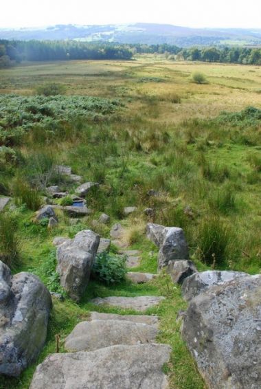
Little John's Well. Steps lead down to a water trough fed by a natural spring / Roger Temple, 5 Sep. 2007, Creative Commons, via Geograph.
By Henrik Thiil Nielsen, 2016-08-31. Revised by Henrik Thiil Nielsen, 2021-01-06.
Little John's Well in Hathersage parish is located c. 475 m SSE of Longshaw Lodge and c. 500 m SSW of Robin Hood's Well. Dobson & Taylor are no doubt correct in noting that the two wells are "closely related".[1] So far the first source I known to mention this Little John's Well is the 6" O.S. map of the area published in 1882 (see Maps section below).[2]
Gazetteers
- Dobson, R. B., ed.; Taylor, J., ed. Rymes of Robyn Hood: an Introduction to the English Outlaw (London, 1976), p. 296, s.n. 'Little John's Well'.
Sources
Background
Maps
- 6" O.S. map Derbyshire XVII.NW (1883; surveyed 1876-80)
- 6" O.S. map Derbyshire XVII.NW (1898; surveyed 1897)
- 6" O.S. map Derbyshire XVII.NW (1923; rev. 1919)
- 6" O.S. map Derbyshire XVII (1924; rev. 1919)
- 6" O.S. map Derbyshire XVII (c. 1933; rev. 1919)
- 1" O.S. map Sheet 100 (1909).
Also see
- Outseats place-name cluster
- Hathersage place-name cluster
- Places named Little John's Well
- Places named after Little John.
Notes
- ↑ Dobson, R. B., ed.; Taylor, J., ed. Rymes of Robyn Hood: an Introduction to the English Outlaw (London, 1976), p. 296, s.n. 'Little John's Well'.
- ↑ This place-name is not included in Cameron, Kenneth. The Place-Names of Derbyshire (English Place-Name Society, vols. XXVII-XXIX) (Cambridge, 1959).
