
Little John's Well (Hampole): Difference between revisions
m (Text replacement - "(subscription required)" to "(£)") |
m (Text replacement - ", image" to ", Image") |
||
| (5 intermediate revisions by the same user not shown) | |||
| Line 4: | Line 4: | ||
[[File:ljs-well-hampole-gerald-england.jpg|thumb|right|400px|Little John's Well, 1967 / [http://www.geraldengland.co.uk/old/oldy012.htm Gerald England.]]]<div class="no-img"> | [[File:ljs-well-hampole-gerald-england.jpg|thumb|right|400px|Little John's Well, 1967 / [http://www.geraldengland.co.uk/old/oldy012.htm Gerald England.]]]<div class="no-img"> | ||
<p id="byline">By Henrik Thiil Nielsen, 2013-07-10. Revised by {{#realname:{{REVISIONUSER}}}}, {{REVISIONYEAR}}-{{REVISIONMONTH}}-{{REVISIONDAY2}}. Photo: [http://www.geograph.org.uk/profile/22742 Gerald England]''</p> | <p id="byline">By Henrik Thiil Nielsen, 2013-07-10. Revised by {{#realname:{{REVISIONUSER}}}}, {{REVISIONYEAR}}-{{REVISIONMONTH}}-{{REVISIONDAY2}}. Photo: [http://www.geograph.org.uk/profile/22742 Gerald England]''</p> | ||
The now derelict Little John's Well is located on the NE side of Doncaster Road (A638), 1.3 km NW of Hampole, a little west of Barnsdale. The name is first recorded in an 1838 MS Tithe Award where it appears as "Little John's Cave & Well", while on an 1841 Ordnance Survey map the locality is indicated as "Lt. John's Well"<ref name=Smith>{{:Smith, Albert Hugh 1961a}}, pt. II, p. 44. | The now derelict Little John's Well is located on the NE side of Doncaster Road (A638), 1.3 km NW of Hampole, a little west of Barnsdale. The name is first recorded in an 1838 MS Tithe Award where it appears as "Little John's Cave & Well", while on an 1841 Ordnance Survey map the locality is indicated as "Lt. John's Well"<ref name=Smith>{{:Smith, Albert Hugh 1961a}}, pt. II, p. 44. The tithe award is not that for Hampole, online at [https://www.thegenealogist.co.uk the Genealogist], Piece 43, sub-piece 190, Image 288-90 (£), which is dated 1838 and appears to be complete though running to three pages only. IRHB has not found any reference to Little John's Well in the tithe awards for neighbouring townships online at The Genealogist. Evidently the tithe award in question is not at the National Archives.</ref> The well water used to fill a stone trough that had the name "Little John's Well" incised on the front. What remains of the masonry at the well is grade II listed, described as follows: "Remains of seat. Probably C17. Limestone slab standing upright and with recessed panel on one face with the initials 'AL' crudely inscribed beneath a carved device of a 5-petalled rose in a shield. Irregularly-shaped head"<ref>[http://www.britishlistedbuildings.co.uk/en-334478-seat-at-little-johns-well-approximately- British Listed Buildings: Seat at Little Johns Well].</ref> In addition to the name "Little John's Well", the 6" O.S. map published in 1854, based on surveying done in 1849, includes the legend "Trough" and shows a structure which is clearly of the same shape as that shown on Gerald England's photos (see below), thus indicating that the stone structure was certainly in place by the mid-nineteenth century.<ref>See Maps section below.</ref> | ||
The site is now dry as the water has been diverted to nearby lakes, and the inscription, clearly visible on the photo in Mitchell (1970),<ref>{{:Mitchell, William Reginald 1970a}}, p. 4.</ref> can no longer be traced. Near the well was the site known as [[Little John's Cave (Hampole)|Little John's Cave]], but this appears to have been filled in. The locality is very close to Hazel Lane Quarry, an active limestone quarry.{{PlaceNamesItemAllusionsAndRecords}} | The site is now dry as the water has been diverted to nearby lakes, and the inscription, clearly visible on the photo in Mitchell (1970),<ref>{{:Mitchell, William Reginald 1970a}}, p. 4.</ref> can no longer be traced. In 2021, Little John's Well was said to be "sadly now well overgrown and vandalised [...] The stone quarry behind the well has been excavated over the years with the natural spring that fed it also drying up".<ref>[https://youtu.be/Qtfm6Xmqsjs The Villaeg Idiot: Doncaster Round-Up (YouTube).]</ref> Near the well was the site known as [[Little John's Cave (Hampole)|Little John's Cave]], but this appears to have been filled in. The locality is very close to Hazel Lane Quarry, an active limestone quarry.{{PlaceNamesItemAllusionsAndRecords}} | ||
== Gazetteers == | == Gazetteers == | ||
* {{:Dobson, Richard Barrie 1976a}}, p. 308. | * {{:Dobson, Richard Barrie 1976a}}, p. 308. | ||
=== MS Sources === | === MS Sources === | ||
* 1838 Tithe Award; cf. Smith.<ref name=Smith></ref> Little John's Well is not listed in the 1838 tithe award for Hampole online at [https://www.thegenealogist.co.uk the Genealogist], Piece 43, sub-piece 190, | * 1838 Tithe Award; cf. Smith.<ref name=Smith></ref> Little John's Well is not listed in the 1838 tithe award for Hampole online at [https://www.thegenealogist.co.uk the Genealogist], Piece 43, sub-piece 190, Image 288-90 (£), but it is probably incomplete as it runs to only three pages. | ||
== Printed sources == | == Printed sources == | ||
| Line 32: | Line 32: | ||
== Background == | == Background == | ||
* [http://epns.nottingham.ac.uk/browse/id/53288204b47fc40c81005730-Little+Johns+Well Survey of English Place-Names: Little John's Well] | |||
* [https://youtu.be/Qtfm6Xmqsjs The Villaeg Idiot: Doncaster Round-Up (YouTube)] | |||
* [http://en.wikipedia.org/wiki/Hampole Wikipedia: Hampole.] | * [http://en.wikipedia.org/wiki/Hampole Wikipedia: Hampole.] | ||
{{PlaceNamesItemAlsoSee}} | {{PlaceNamesItemAlsoSee}} | ||
Latest revision as of 18:31, 22 April 2022
| Locality | |
|---|---|
| Coordinate | 53.592061, -1.247162 |
| Adm. div. | West Riding of Yorkshire |
| Vicinity | 1.3 km NW of Hampole |
| Type | Monument |
| Interest | Robin Hood name |
| Status | Extant? |
| First Record | 1838 |


By Henrik Thiil Nielsen, 2013-07-10. Revised by Henrik Thiil Nielsen, 2022-04-22. Photo: Gerald England
The now derelict Little John's Well is located on the NE side of Doncaster Road (A638), 1.3 km NW of Hampole, a little west of Barnsdale. The name is first recorded in an 1838 MS Tithe Award where it appears as "Little John's Cave & Well", while on an 1841 Ordnance Survey map the locality is indicated as "Lt. John's Well"[1] The well water used to fill a stone trough that had the name "Little John's Well" incised on the front. What remains of the masonry at the well is grade II listed, described as follows: "Remains of seat. Probably C17. Limestone slab standing upright and with recessed panel on one face with the initials 'AL' crudely inscribed beneath a carved device of a 5-petalled rose in a shield. Irregularly-shaped head"[2] In addition to the name "Little John's Well", the 6" O.S. map published in 1854, based on surveying done in 1849, includes the legend "Trough" and shows a structure which is clearly of the same shape as that shown on Gerald England's photos (see below), thus indicating that the stone structure was certainly in place by the mid-nineteenth century.[3]
The site is now dry as the water has been diverted to nearby lakes, and the inscription, clearly visible on the photo in Mitchell (1970),[4] can no longer be traced. In 2021, Little John's Well was said to be "sadly now well overgrown and vandalised [...] The stone quarry behind the well has been excavated over the years with the natural spring that fed it also drying up".[5] Near the well was the site known as Little John's Cave, but this appears to have been filled in. The locality is very close to Hazel Lane Quarry, an active limestone quarry.
Gazetteers
MS Sources
- 1838 Tithe Award; cf. Smith.[1] Little John's Well is not listed in the 1838 tithe award for Hampole online at the Genealogist, Piece 43, sub-piece 190, Image 288-90 (£), but it is probably incomplete as it runs to only three pages.
Printed sources
- British Listed Buildings: Seat at Little Johns Well.
- Megalithic Portal: Little John's Well
- Mitchell, W.R. The Haunts of Robin Hood (Clapham via Lancaster, 1970), p. 4. Photo.
- Smith, A.H. The Place-Names of the West Riding of Yorkshire (English Place-Name Society, vols. XXX-XXXVII) (Cambridge, 1961-63), pt. II, p. 44; pt. VII, p. 73.
Maps
- 1841 O.S. map; not seen, but cf. Smith.[1]
- 25" O.S. map Yorkshire CCLXIV.14 (1893; surveyed 1891)
- 25" O.S. map Yorkshire CCLXIV.14 (1906; surveyed 1904)
- 25" O.S. map Yorkshire CCLXIV.14 (1932; surveyed 1930)
- 6" O.S. map Yorkshire 264 (1854, surveyed 1849)
- 6" O.S. map Yorkshire Sheet CCLXIV.SW (1894, rev. 1891)
- 6" O.S. map Yorkshire Sheet CCLXIV.SW (1907, rev. 1904)
- 6" O.S. map Yorkshire Sheet CCLXIV.SW (1930, rev. 1930)
- 6" O.S. map Yorkshire Sheet CCLXIV.SW (1950, rev. 1948)
- O.S. 1:25,000 map SE41 (1953).
Background
- Survey of English Place-Names: Little John's Well
- The Villaeg Idiot: Doncaster Round-Up (YouTube)
- Wikipedia: Hampole.
Also see
Notes
- ↑ 1.0 1.1 1.2 Smith, A.H. The Place-Names of the West Riding of Yorkshire (English Place-Name Society, vols. XXX-XXXVII) (Cambridge, 1961-63), pt. II, p. 44. The tithe award is not that for Hampole, online at the Genealogist, Piece 43, sub-piece 190, Image 288-90 (£), which is dated 1838 and appears to be complete though running to three pages only. IRHB has not found any reference to Little John's Well in the tithe awards for neighbouring townships online at The Genealogist. Evidently the tithe award in question is not at the National Archives.
- ↑ British Listed Buildings: Seat at Little Johns Well.
- ↑ See Maps section below.
- ↑ Mitchell, W.R. The Haunts of Robin Hood (Clapham via Lancaster, 1970), p. 4.
- ↑ The Villaeg Idiot: Doncaster Round-Up (YouTube).
Image gallery
Click any image to display it in the lightbox, where you can navigate between images by clicking in the right or left side of the current image.
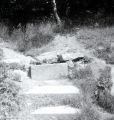
All is not well at Little John's Well, Hampole / Gerald England.
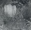
Little John's Well, 1967 / Gerald England.