Ivanhoe Villas (Stapenhill): Difference between revisions
From International Robin Hood Bibliography
mNo edit summary |
m (Text replacement - "No Copy in NLS" to "No copy in NLS") |
||
| (18 intermediate revisions by the same user not shown) | |||
| Line 1: | Line 1: | ||
__NOTOC__{{ | __NOTOC__{{PlaceNamesItemTop|Lat=52.797062|Lon=-1.619413|AdministrativeDivision=Derbyshire|Vicinity=7–15 Malvern Street|Type=Building|Interest=Robin Hood name| | ||
Status=Extant|Demonym=|Riding=|GreaterLondon=|Year=1884|Aka=|Century=|Cluster1=|Cluster2=|Cluster3=|Image=ivanhoe-villas-stapenhill-google-earth-street-view.jpg|Postcards=|ExtraCat1=Places named after Ivanhoe|ExtraCat2=|ExtraCat3=|ExtraCat4=|ExtraCat5=|ExtraLink1=|ExtraLink2=|ExtraLink3=|ExtraLink4=|ExtraLink5=|ExtraLinkName1=|ExtraLinkName2=|ExtraLinkName3=|ExtraLinkName4=|ExtraLinkName5=|GeopointPrefix=|GeopointSuffix=|VicinitySuffix=|StatusSuffix=?|DatePrefix=|DateSuffix=}} | Status=Extant|Demonym=|Riding=|GreaterLondon=|Year=1884|Aka=|Century=|Cluster1=|Cluster2=|Cluster3=|Image=ivanhoe-villas-stapenhill-google-earth-street-view.jpg|Postcards=|ExtraCat1=Places named after Ivanhoe|ExtraCat2=|ExtraCat3=|ExtraCat4=|ExtraCat5=|ExtraLink1=|ExtraLink2=|ExtraLink3=|ExtraLink4=|ExtraLink5=|ExtraLinkName1=|ExtraLinkName2=|ExtraLinkName3=|ExtraLinkName4=|ExtraLinkName5=|GeopointPrefix=|GeopointSuffix=|VicinitySuffix=|StatusSuffix=?|DatePrefix=|DateSuffix=}} | ||
{{#display_map:{{#var:Coords}}~{{#replace:{{PAGENAME}}|'|'}}|width=34%|fullscreen=yes}}<div class="pnMapLegend"> | {{#display_map:{{#var:Coords}}~{{#replace:{{PAGENAME}}|'|'}}|width=34%|fullscreen=yes}}<div class="pnMapLegend">The row of houses once (or still?) known as Ivanhoe Villas.</div> | ||
[[File:{{#var: | [[File:{{#var:Image}}|thumb|right|500px|The former or current Ivanhoe Villas / Google Earth Street View.]] | ||
<div class="no-img"><p id="byline">By Henrik Thiil Nielsen, 2020-12-23. Revised by {{#realname:{{REVISIONUSER}}}}, {{REVISIONYEAR}}-{{REVISIONMONTH}}-{{REVISIONDAY2}}.</p> | <div class="no-img"><p id="byline">By Henrik Thiil Nielsen, 2020-12-23. Revised by {{#realname:{{REVISIONUSER}}}}, {{REVISIONYEAR}}-{{REVISIONMONTH}}-{{REVISIONDAY2}}.</p> | ||
A still existing row of houses on 7 to 15 Malvern Street, Stapenhill, Burton-upon-Trent, | A still existing row of houses on 7 to 15 Malvern Street, Stapenhill, Burton-upon-Trent, was known as 'Ivanhoe Villas' around 1884. | ||
The name appears next to these houses on 6" and 25" O.S. maps published in 1884, based on surveys carried out in 1881 | The name appears next to these houses on 6" and 25" O.S. maps published in 1884, based on surveys carried out in 1881 and 1882, but no name is included on later O.S. maps of the area. It is unclear if the name is still in use. Though most of Stapenhill is in Staffordshire, the area in which Malvern Street is situated is or was formerly in Derbyshire.<ref>See map on the page on [[Derbyshire place-names]], which uses historical county boundary coordinates provided by the [http://www.county-borders.co.uk/ Historic Counties Trust.] Wikipedia does not mention the fact that Stapenhill straddled the boundary between these two pre-1972 counties. See [https://en.wikipedia.org/wiki/Stapenhill Wikipedia: Stapenhill.]</ref>{{PlaceNamesItemAllusionsAndRecords}} | ||
{{ | |||
== Gazetteers == | == Gazetteers == | ||
* Not included in {{:Dobson, Richard Barrie 1976a}}, pp. 293-311. | * Not included in {{:Dobson, Richard Barrie 1976a}}, pp. 293-311. | ||
| Line 14: | Line 13: | ||
== Maps == | == Maps == | ||
* [https://maps.nls.uk/view/115473414#zoom=6&lat=5024&lon=4230&layers=BT 25" O.S. map ''Staffordshire'' XLI.13 (1884; surveyed 1881–82)] | * [https://maps.nls.uk/view/115473414#zoom=6&lat=5024&lon=4230&layers=BT 25" O.S. map ''Staffordshire'' XLI.13 (1884; surveyed 1881–82)] | ||
* 25" O.S. map ''Staffordshire'' XLI.13 (''c.'' 1901; rev. ''c.'' 1900). No | * 25" O.S. map ''Staffordshire'' XLI.13 (''c.'' 1901; rev. ''c.'' 1900). No copy in NLS | ||
* [https://maps.nls.uk/view/114591101#zoom=6&lat=4873&lon=4781&layers=BT 25" O.S. map ''Derbyshire'' LVII.13 (1923; rev. 1920)] | * [https://maps.nls.uk/view/114591101#zoom=6&lat=4873&lon=4781&layers=BT 25" O.S. map ''Derbyshire'' LVII.13 (1923; rev. 1920)] | ||
* [https://maps.nls.uk/geo/explore/#zoom=17&lat=52.79721&lon=-1.62006&layers=168&b=5 25" O.S. map ''Derbyshire'' LVII.13 (1923; rev. 1920)] (georeferenced) | * [https://maps.nls.uk/geo/explore/#zoom=17&lat=52.79721&lon=-1.62006&layers=168&b=5 25" O.S. map ''Derbyshire'' LVII.13 (1923; rev. 1920)] (georeferenced) | ||
| Line 26: | Line 25: | ||
* --> | * --> | ||
== Background == | == Background == | ||
* [https://en.wikipedia.org/wiki/Stapenhill Wikipedia: Stapenhill] | * [https://en.wikipedia.org/wiki/Stapenhill Wikipedia: Stapenhill.] | ||
<!--== Brief mention == | <!--== Brief mention == | ||
* --> | * --> | ||
{{ | {{PlaceNamesItemAlsoSee}} | ||
== Notes == | == Notes == | ||
<references/ | <references/> | ||
</div><!-- | </div><!-- | ||
{{ | {{ImageGalleryIntroduction}} | ||
<gallery widths="195px"> | <gallery widths="195px"> | ||
FOR EACH IMAGE: File:_FILENAME.jpg|_LEGEND / [_URL _PHOTOGRAPHER, _DAY _MON. _YEAR, Creative Commons.] | FOR EACH IMAGE: File:_FILENAME.jpg|_LEGEND / [_URL _PHOTOGRAPHER, _DAY _MON. _YEAR, Creative Commons.] | ||
| Line 42: | Line 41: | ||
{{ | {{PlaceNamesItemNavigation}} | ||
Latest revision as of 01:00, 13 February 2021
| Locality | |
|---|---|
| Coordinate | 52.797062, -1.619413 |
| Adm. div. | Derbyshire |
| Vicinity | 7–15 Malvern Street |
| Type | Building |
| Interest | Robin Hood name |
| Status | Extant? |
| First Record | 1884 |
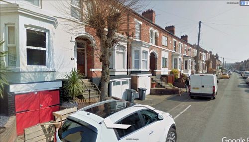
The row of houses once (or still?) known as Ivanhoe Villas.
By Henrik Thiil Nielsen, 2020-12-23. Revised by Henrik Thiil Nielsen, 2021-02-13.
A still existing row of houses on 7 to 15 Malvern Street, Stapenhill, Burton-upon-Trent, was known as 'Ivanhoe Villas' around 1884.
The name appears next to these houses on 6" and 25" O.S. maps published in 1884, based on surveys carried out in 1881 and 1882, but no name is included on later O.S. maps of the area. It is unclear if the name is still in use. Though most of Stapenhill is in Staffordshire, the area in which Malvern Street is situated is or was formerly in Derbyshire.[1]
Gazetteers
- Not included in Dobson, R. B., ed.; Taylor, J., ed. Rymes of Robyn Hood: an Introduction to the English Outlaw (London, 1976), pp. 293-311.
Maps
- 25" O.S. map Staffordshire XLI.13 (1884; surveyed 1881–82)
- 25" O.S. map Staffordshire XLI.13 (c. 1901; rev. c. 1900). No copy in NLS
- 25" O.S. map Derbyshire LVII.13 (1923; rev. 1920)
- 25" O.S. map Derbyshire LVII.13 (1923; rev. 1920) (georeferenced)
- 6" O.S. map Derbyshire LVII.SW (1884; surveyed 1882)
- 6" O.S. map Derbyshire LVII.SW (1902; rev. 1900) (georeferenced)
- 6" O.S. map Derbyshire LVII.SW (1902; rev. 1900)
- 6" O.S. map Derbyshire LVII (1924; rev. 1920)
- 6" O.S. map Derbyshire LVII.SW (1924; rev. 1920)
- 6" O.S. map Derbyshire LVII.SW (c. 1948; rev. 1938).
Background
Also see
Notes
- ↑ See map on the page on Derbyshire place-names, which uses historical county boundary coordinates provided by the Historic Counties Trust. Wikipedia does not mention the fact that Stapenhill straddled the boundary between these two pre-1972 counties. See Wikipedia: Stapenhill.

