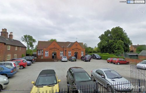
Ivanhoe House (Smisby): Difference between revisions
From International Robin Hood Bibliography
m (Text replacement - "<h3>Records</h3>" to "<h2>Records</h2>") |
m (Text replacement - "=== Postcards ===" to "== Postcards ==") |
||
| Line 18: | Line 18: | ||
* [http://maps.nls.uk/geo/explore/#zoom=17&lat=52.7688&lon=-1.4832&layers=171&b=1 6" O.S. map ''Derbyshire'' LXI.NW] (1904; rev. 1899) (georeferenced) | * [http://maps.nls.uk/geo/explore/#zoom=17&lat=52.7688&lon=-1.4832&layers=171&b=1 6" O.S. map ''Derbyshire'' LXI.NW] (1904; rev. 1899) (georeferenced) | ||
* [http://maps.nls.uk/view/101601918#zoom=6&lat=2345&lon=1399&layers=BT 6" O.S. map ''Derbyshire'' LXI.NW] (1925; rev. 1920) | * [http://maps.nls.uk/view/101601918#zoom=6&lat=2345&lon=1399&layers=BT 6" O.S. map ''Derbyshire'' LXI.NW] (1925; rev. 1920) | ||
<!-- | <!--== Postcards == | ||
* | * | ||
== Discussion == | == Discussion == | ||
Revision as of 15:33, 12 July 2018
Ivanhoe House.
By Henrik Thiil Nielsen, 2017-05-08. Revised by Henrik Thiil Nielsen, 2018-07-12.
Ivanhoe House on Smisby Main Street is the home of Ivanhoe Equestrian, formerly a riding school, now offering horse training facilities for hire.
A house in Cliftonthorpe, less than one km from Smisby, was known as Ivanhoe House in the late 19th century.
Gazetteers
- Not included in Dobson, R. B., ed.; Taylor, J., ed. Rymes of Robyn Hood: an Introduction to the English Outlaw (London, 1976), pp. 293-311.
Sources
Maps
Ivanhoe House is indicated without a legend on these maps of the area.
- 6" O.S. map Derbyshire LXI.NW (1902; rev. 1889)
- 6" O.S. map Derbyshire LXI.NW (1904; rev. 1899)
- 6" O.S. map Derbyshire LXI.NW (1904; rev. 1899) (georeferenced)
- 6" O.S. map Derbyshire LXI.NW (1925; rev. 1920)
Background

