
Friar Tuck Shop (Chapel St Leonards): Difference between revisions
mNo edit summary |
mNo edit summary |
||
| Line 1: | Line 1: | ||
__NOTOC__{{PnItemTop|Lat=53. | __NOTOC__{{PnItemTop|Lat=53.216243|Lon=0.335334|AdmDiv=Lincolnshire|Vicinity=E side of S Road, Chapel St Leonards, immediately S of entrance to the Robin Hood Camp (now the Golden Palm Resort)|Type=Establishment|Interest=Robin Hood name|Status=Defunct|Demonym=English|Riding=|GreaterLondon=|Year=1958|Aka=|Century=|Cluster1=Chapel St Leonards|Cluster2=|Cluster3=|Image=friar-tuck-shop-chapel-st-leonards-google-earth-street-view.jpg|Postcards=Yes|ExtraCat1=Places named after Friar Tuck|ExtraCat2=|ExtraCat3=|ExtraCat4=|ExtraCat5=|ExtraLink1=|ExtraLink2=|ExtraLink3=|ExtraLink4=|ExtraLink5=|ExtraLinkName1=|ExtraLinkName2=|ExtraLinkName3=|ExtraLinkName4=|ExtraLinkName5=|GeopointPrefix=|GeopointSuffix=|StatusSuffix=|DatePrefix=|DateSuffix=}} | ||
{{#display_map:{{#var:Coords}}~{{#replace:{{PAGENAME}}|'|'}}|service=leaflet|width=34%}}<div class="pnMapLegend">Site of Friar Tuck Shop, immediately S of entrance to Robin Hood Camp (now Golden Palm Resort.</div> | {{#display_map:{{#var:Coords}}~{{#replace:{{PAGENAME}}|'|'}}|service=leaflet|width=34%}}<div class="pnMapLegend">Site of Friar Tuck Shop, immediately S of entrance to Robin Hood Camp (now Golden Palm Resort.</div> | ||
[[File:{{#var:Pnimage}}|thumb|right|500px|Site of Friar Tuck Shop / Google Earth Street View.]] | [[File:{{#var:Pnimage}}|thumb|right|500px|Site of Friar Tuck Shop / Google Earth Street View.]] | ||
Revision as of 21:21, 16 May 2019
[[File:|thumb|right|500px|Site of Friar Tuck Shop / Google Earth Street View.]]
By Henrik Thiil Nielsen, 2019-05-16. Revised by Henrik Thiil Nielsen, 2019-05-16.
On the south side of the entrance to the Robin Hood Camp – now the Golden Palm Resort – in Chapel St leonards was a Friar Tuck Shop from at least the 1950s to 1970s.
The shop can be seen on the postcards from 1958 and the 1970s shown in the image gallery below.
Gazetteers
- Not included in Dobson, R. B., ed.; Taylor, J., ed. Rymes of Robyn Hood: an Introduction to the English Outlaw (London, 1976), pp. 293-311.
Maps
Shop not labelled or indicated on maps.
- 25" O.S. map Lincolnshire LXXVI.7 (c. 1889; surveyed c. 1888). No Copy in NLS
- 25" O.S. map Lincolnshire LXXVI.7 (1906; rev. 1905) (georeferenced)]
- 25" O.S. map Lincolnshire LXXVI.7 (1906; rev. 1905)
- 6" O.S. map Lincolnshire LXXVI.NE (1907; rev. 1905) (georeferenced)]
- 6" O.S. map Lincolnshire LXXVI.NE (1888; surveyed 1888)
- 6" O.S. map Lincolnshire LXXVI.NE (1907; rev. 1905)
- 6" O.S. map Lincolnshire LXXVI.NE (c. 1948; rev. 1938)
- 6" O.S. map Lincolnshire LXXVI.NE (1951; rev. 1946).
Background
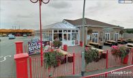
Site of Friar Tuck Shop / Google Earth Street View..
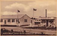
Robin Hood Camp with Friar Tuck shop right / Postcard dated c. 1958, from now defunct site lincolnshirepostcards.co.uk.
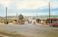
Robin Hood Camp with Friar Tuck shop right (?1970s) / Photo Precision Ltd. Robin Hood Camp, Chapel St. Leonards (R102) ([s.l.], [c. 1970]). Photographic postcard (col.). 139 x 89 mm.; private collection.


