
Friar Tuck's Well (Blidworth): Difference between revisions
m (Text replacement - "|service=leaflet|" to "|") |
m (Text replacement - "AdmDiv" to "AdministrativeDivision") |
||
| Line 1: | Line 1: | ||
__NOTOC__{{PnItemTop|Lat=53.1059|Lon=-1.1512| | __NOTOC__{{PnItemTop|Lat=53.1059|Lon=-1.1512|AdministrativeDivision=Nottinghamshire|Vicinity=2.2 km NW of Blidworth|Type=Natural feature|Interest=Robin Hood name|Status=Extant|Demonym=|Riding=|GreaterLondon=|Year=1885|Aka=|Century=|Cluster1=Fountain Dale|Cluster2=|Cluster3=|Image=friar-tucks-well-antony-dixon.jpg|Postcards=|ExtraCat1=Places named after Friar Tuck|ExtraCat2=|ExtraCat3=|ExtraCat4=|ExtraCat5=|ExtraLink1=|ExtraLink2=|ExtraLink3=|ExtraLink4=|ExtraLink5=|ExtraLinkName1=|ExtraLinkName2=|ExtraLinkName3=|ExtraLinkName4=|ExtraLinkName5=|GeopointPrefix=|GeopointSuffix=|StatusSuffix=|DatePrefix=|DateSuffix=}} | ||
{{#display_map:{{#var:Coords}}~{{#replace:{{PAGENAME}}|'|'}}|width=34%|enablefullscreen=yes}}<div class="pnMapLegend">Friar Tuck's Well, immediately NE of [[Fountain Dale (Blidworth)|Fountain Dale]], another Robin Hood-related locality.</div> | {{#display_map:{{#var:Coords}}~{{#replace:{{PAGENAME}}|'|'}}|width=34%|enablefullscreen=yes}}<div class="pnMapLegend">Friar Tuck's Well, immediately NE of [[Fountain Dale (Blidworth)|Fountain Dale]], another Robin Hood-related locality.</div> | ||
[[File:friar-tucks-well-antony-dixon.jpg|thumb|right|350px|Friar Tuck's Well / [http://www.geograph.org.uk/photo/2742019 Antony Dixon, 27 Dec. 2011, Creative Commons, via Geograph.]]]<div class="no-img"> | [[File:friar-tucks-well-antony-dixon.jpg|thumb|right|350px|Friar Tuck's Well / [http://www.geograph.org.uk/photo/2742019 Antony Dixon, 27 Dec. 2011, Creative Commons, via Geograph.]]]<div class="no-img"> | ||
Revision as of 21:18, 5 January 2021

By Henrik Thiil Nielsen, 2016-10-05. Revised by Henrik Thiil Nielsen, 2021-01-05. Photos and comments courtesy Rich.
Friar Tuck's Well is situated on the east of Fountain Dale. This chalybeate spring once was surrounded by a low wall and an ornate iron railing; the water emerged from a pipe, traces of which can still be discerned as a dark patch close to the top of Antony Dixon's photo below, and trickled down the "stairs" seen in the centre of the photo. Its waters were believed to possess medicinal properties. The well is now overgrown, the immediate surroundings boggy and the stonework broken.[1]
IRHB user Rich visited the locality in mid-September of 2020 and mailed me a photo with some comments. Such contributions are always received with thanks. You can contact IRHB via the form on th eContactpage. You can see Rich's photo in the gallery below. Here are his comments:
Gazetteers
- Dobson, R. B., ed.; Taylor, J., ed. Rymes of Robyn Hood: an Introduction to the English Outlaw (London, 1976), p. 302, s.n. 'Friar Tuck's Well'.
Sources
- Geograph: SK5656: 'Friar Tuck's Well' by Antony Dixon
- HolyAndHealingWells: 'Perhaps not so jolly old
- HolyAndHealingWells:: 'Friar Tuck’s Well…new…well actually old photos', by pixyledpublications'.
Maps
- 25" O.S. map Nottinghamshire XXVIII.10 (1885; surveyed 1884)
- 25" O.S. map Nottinghamshire XXVIII.10 (1900; rev. 1897)
- 25" O.S. map Nottinghamshire XXVIII.10 (1900; rev. 1897) (georeferenced)
- 25" O.S. map Nottinghamshire XXVIII.10 (1915; rev. 1913)
- 6" O.S. map Nottinghamshire XXVIII.SW (1885; surveyed 1877-83)
- 6" O.S. map Nottinghamshire XXVIII.SW (1900; rev. 1897–98) (georeferenced)
- 6" O.S. map Nottinghamshire XXVIII.SW (1900; rev. 1897-98)
- 6" O.S. map Nottinghamshire XXVIII.SW (1920; rev. 1913)
- 6" O.S. map Nottinghamshire XXVIII.SW (1939; rev. c. 1949).
Background
- Nottingham Wayfarers' Rambling Club; Price, Roland, introd. The Robin Hood Walks: A Comprehensive Guide to Walks in Robin Hood Country including the Third Edition of the Guide to the Full Route of Nottinghamshire's First Recreational Footpath, The Robin Hood Way (Leicester: Cordee, ©1994); Friar Tuck's Well and/or Fountaindale: pp. 41, 42, 43, 44 (map), 98, 114, 117 (map)
- UK Wanderings: Fountain Dale and Blidworth.
Notes
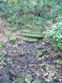
Friar Tuck's Well / Antony Dixon, 27 Dec. 2011, Creative Commons, via Geograph.
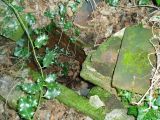
The well is in a sorry state / 'pixyledpublications'.
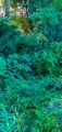
Near the well. See text / Courtesy Rich, 12 Sep. 2020

