
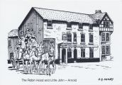
Robin Hood and Little John (Arnold)
| Locality | |
|---|---|
| Coordinate | 53.00665, -1.127358 |
| Adm. div. | Nottinghamshire |
| Vicinity | Intersection of Church and Cross streets in Arnold |
| Type | Public house |
| Interest | Robin Hood name |
| Status | Extant |
| First Record | 1796 |
| A.k.a. | Robin Hood (and) Little John; Robin Hood Inn |

By Henrik Thiil Nielsen, 2018-05-27. Revised by Henrik Thiil Nielsen, 2022-05-05. Photo courtesy Ross Parish, author of books and a blog on English holy wells.
The Robin Hood and Little John has traded under that name – now using the quirky variant "Robin Hood (and) Little John" – ever since 1796, when it opened in premises newly built for the purpose by Thomas Sturtivant, keeper of Nottingham jail,[1]
In the tithe award for Arnold (1842) the land on which the pub stands is listed as "Robin Hood Inn & Yard", the landowners as the trustees of Stirtevant, and the area as 13 perches (531.15 m2).[2] As is usually the case with public houses in urban areas, the Robin Hood and Little John is only indicated as "P.H." on late 19th to mid-20th century O.S. maps (see Maps section below); on some it is not labelled at all. Information on publicans for the years 1925-41 can be found at Pub History.[3]
Gazetteers
- Not included in Dobson, R. B., ed.; Taylor, J., ed. Rymes of Robyn Hood: an Introduction to the English Outlaw (London, 1976), pp. 293-311.
MS Sources
- The Genealogist: Arnold tithe award, Piece 26, Sub-Piece 001, Image 81, No. 1072 (1842) (£)
- The Genealogist: Arnold tithe map, Piece 26, Sub-Piece 1, Sub-Image 001 (1842) (£).
Printed and online sources
Maps
- 25" O.S. map Nottinghamshire XXXVIII.6 (1883; surveyed 1877-81)
- 25" O.S. map Nottinghamshire XXXVIII.6 (1900; rev. 1899)
- 25" O.S. map Nottinghamshire XXXVIII.6 (1900; rev. 1899) (georeferenced)
- 25" O.S. map Nottinghamshire XXXVIII.6 (1915; rev. 1913)
- 6" O.S. map Nottinghamshire XXXVIII.NW (1885; surveyed 1878-81)
- 6" O.S. map Nottinghamshire XXXVIII.NW (1901; rev. 1899)
- 6" O.S. map Nottinghamshire XXXVIII.NW (1901; rev. 1899) (georeferenced)
- 6" O.S. map Nottinghamshire XXXVIII.NW (1921; rev. 1913)
- 6" O.S. map Nottinghamshire XXXVIII.NW (c. 1947; rev. 1938).
Background
- Facebook: The Robin Hood (and) Little John
- Pub website
- Visit Nottinghamshire: A History of Arnold & The Robin Hood (AND) Little John Pub.
Also see
Notes
- ↑ Home Brewery PLC/Midlands Postal Board. The Robin Hood and Little John – Arnold ([s.l.], [1985]). Picture postcard (b./w.). 150 x 105 mm.
- ↑ The Genealogist: Arnold tithe award, Piece 26, Sub-Piece 001, Image 81, No. 1072 (1842) (£). No occupier (or state of cultivation) is given.
- ↑ Pub History: Robin Hood, Church Street, Arnold, Nottinghamshire.
Image gallery
Click any image to display it in the lightbox, where you can navigate between images by clicking in the right or left side of the current image.
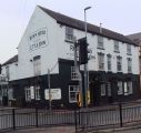
The Robin Hood (and) Little John / Photo courtesy Ross Parish.
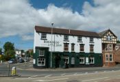
The Robin Hood (and) Little John. Operating on the site for perhaps 250 years, this pub is currently run by the Lincoln Green Brewery / Alan Murray-Rust, 27 jul. 2016, Creative Commons, via Geograph.
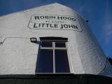
Robin Hood (and) Little John, Church Street, Arnold / Stephen McKay, 18 Apr. 2015, Creative Commons, via Geograph.
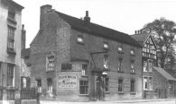
The Robin Hood and Little john in the black and white era / Facebook: The Robin Hood (and) Little John.
The pub in modern black and white / Home Brewery PLC/Midlands Postal Board. The Robin Hood and Little John – Arnold ([s.l.], [1985]). Picture postcard (b./w.). 150 x 105 mm; HTN collection


