Robin Hood Allotment Gardens (Carlton, Nottingham) (2)
From International Robin Hood Bibliography
| Locality | |
|---|---|
| Coordinate | 52.972943, -1.101966 |
| Adm. div. | Nottinghamshire |
| Vicinity | W. of Cavendish Road, S. of Coningswath Road |
| Type | Area |
| Interest | Robin Hood name |
| Status | Extant |
| First Record | 1947 |
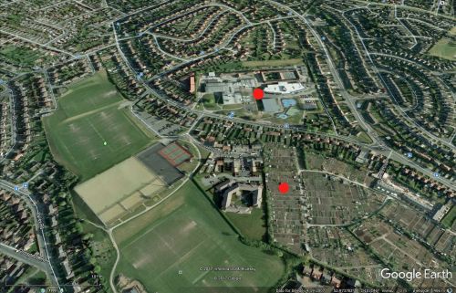
Robin Hood Allotment Gardens at their present location.
By Henrik Thiil Nielsen, 2017-11-12. Revised by Henrik Thiil Nielsen, 2021-01-07.
Robin Hood Allotment Gardens in Carlton, which is now a Nottingham suburb, have been located at their present site, immediately W. of Cavendish Road and S. of Coningswath Road, since at least 1947 and possibly before 1938. Prior to this they were located some 60 m to the north, on the N. side of Coningswath Road in an area now occupied by the Carlton Academy and Carlton Forum Leisure Centre (see maps in Maps section below).[1]
Gazetteers
- Not included in Dobson, R. B., ed.; Taylor, J., ed. Rymes of Robyn Hood: an Introduction to the English Outlaw (London, 1976), pp. 293-311.
Maps
- 25" O.S. map Nottinghamshire XXXVIII.15 (1900; rev. 1899) (allotment gardens at former location)
- 25" O.S. map Nottinghamshire XXXVIII.15 (1914; rev. 1913) (allotment gardens at former location)
- 6" O.S. map Nottinghamshire XXXVIII.SE (1885; surveyed 1878-83) (allotment gardens not indicated)
- 6" O.S. map Nottinghamshire XXXVIII.SE (1901; rev. 1899) (allotment gardens at former location) (georeferenced)
- 6" O.S. map Nottinghamshire XXXVIII.SE (1901; rev. 1899) (allotment gardens at former location)
- 6" O.S. map Nottinghamshire XXXVIII.SE (1920; rev. 1919) (allotment gardens at former location)
- 6" O.S. map Nottinghamshire XXXVIII.SE (1947; rev. 1938) (allotment gardens at new location, indicated without name)
- Gedling Borough Council: Planning Application 2011/0017 (includes link to map).
Also see
- Carlton, Nottingham place-name cluster
- Nottingham place-name cluster
- Places named Robin Hood's Garden
- Robin Hood Allotment Gardens (Carlton, Nottingham) (1).
Notes
- ↑ For precise location see Gedling Borough Council: Planning Application 2011/0017 (includes link to map).

