
Robin Hood Wood (Bassenthwaite): Difference between revisions
mNo edit summary |
m (Text replacement - "ImgGalleryIntro" to "ImageGalleryIntroduction") |
||
| (29 intermediate revisions by 2 users not shown) | |||
| Line 1: | Line 1: | ||
__NOTOC__{{ | __NOTOC__{{PlaceNamesItemTop|Lat=54.6825|Lon=-3.1958|AdministrativeDivision=Cumberland|Vicinity=Immediately N of Bassenthwaite|Type=Natural feature|Interest=Robin Hood name|Status=Extant|Demonym=|Riding=|GreaterLondon=|Year=1867|Aka=Robin Wood|Century=|Cluster1=Bassenthwaite|Cluster2=|Cluster3=|Image=robin-hhod-wood-david-brown-geograph.jpg|Postcards=|ExtraCat1=Places named Robin Hood's Wood|ExtraCat2=|ExtraCat3=|ExtraCat4=|ExtraCat5=|ExtraLink1=|ExtraLink2=|ExtraLink3=|ExtraLink4=|ExtraLink5=|ExtraLinkName1=|ExtraLinkName2=|ExtraLinkName3=|ExtraLinkName4=|ExtraLinkName5=|GeopointPrefix=|GeopointSuffix=|StatusSuffix=|DatePrefix=|DateSuffix=}} | ||
{{#display_map:{{#var:Coords}}|width=34%}}<div class="pnMapLegend">Robin Hood Wood.</div> | {{#display_map:{{#var:Coords}}~{{#replace:{{PAGENAME}}|'|'}}|width=34%|enablefullscreen=yes}}<div class="pnMapLegend">Robin Hood Wood.</div> | ||
[[File:robin-hhod-wood-david-brown-geograph.jpg|thumb|right|500px|Path in Robin Hood Wood / [http://www.geograph.org.uk/photo/4293756 David Brown; Geograph; Creative Commons.]]] | [[File:robin-hhod-wood-david-brown-geograph.jpg|thumb|right|500px|Path in Robin Hood Wood / [http://www.geograph.org.uk/photo/4293756 David Brown; Geograph; Creative Commons.]]]<div class="no-img"> | ||
<p id="byline">By Henrik Thiil Nielsen, 2017-08-30. Revised by {{#realname:{{REVISIONUSER}}}}, {{REVISIONYEAR}}-{{REVISIONMONTH}}-{{REVISIONDAY2}}.</p> | <p id="byline">By Henrik Thiil Nielsen, 2017-08-30. Revised by {{#realname:{{REVISIONUSER}}}}, {{REVISIONYEAR}}-{{REVISIONMONTH}}-{{REVISIONDAY2}}.</p> | ||
Robin Hood Wood is situated immediately north of Bassenthwaite. About 200 m NNW are [[Robin Hood (Bassenthwaite)|Robin Hood]] farm and [[Robin Hood Cottage (Bassenthwaite)|Robin Hood Cottage]]. [[Robin Hood Holiday Park (Bassenthwaite)|Robin Hood Holiday Park]] is located ''c.'' 300 m northwest. Robin Hood Wood is included on the 6" O.S. map of the area published in 1867 as well as subsequent revisions (see Maps section below). | Robin Hood Wood is situated immediately north of Bassenthwaite. About 200 m NNW are [[Robin Hood (Bassenthwaite)|Robin Hood]] farm and [[Robin Hood Cottage (Bassenthwaite)|Robin Hood Cottage]]. [[Robin Hood Holiday Park (Bassenthwaite)|Robin Hood Holiday Park]] is located ''c.'' 300 m northwest. Robin Hood Wood is included on the 6" O.S. map of the area published in 1867 as well as subsequent revisions (see Maps section below). | ||
{{ | {{PlaceNamesItemAllusionsAndRecords}} | ||
== Gazetteers == | |||
* Not included in {{:Dobson, Richard Barrie 1976a}}, pp. 293-311. | * Not included in {{:Dobson, Richard Barrie 1976a}}, pp. 293-311. | ||
== Maps == | |||
* [http://maps.nls.uk/view/102340824#zoom=6&lat=1947&lon=14399&layers=BT 6" O.S. map ''Cumberland'' XLVI (1867; surveyed 1864-65)] | * [http://maps.nls.uk/view/102340824#zoom=6&lat=1947&lon=14399&layers=BT 6" O.S. map ''Cumberland'' XLVI (1867; surveyed 1864-65)] | ||
* [http://maps.nls.uk/view/101091685#zoom=5&lat=2385&lon=7573&layers=BT 6" O.S. map ''Cumberland'' XLVI.SE (1900; rev. 1898)] | * [http://maps.nls.uk/view/101091685#zoom=5&lat=2385&lon=7573&layers=BT 6" O.S. map ''Cumberland'' XLVI.SE (1900; rev. 1898)] | ||
* [http://maps.nls.uk/geo/explore/#zoom=17&lat=54.6836&lon=-3.1997&layers=171&b=1 6" O.S. map ''Cumberland'' XLVI.SE (1900; rev. 1898)] (georeferenced) | * [http://maps.nls.uk/geo/explore/#zoom=17&lat=54.6836&lon=-3.1997&layers=171&b=1 6" O.S. map ''Cumberland'' XLVI.SE (1900; rev. 1898)] (georeferenced) | ||
* [http://maps.nls.uk/view/101091682#zoom=5&lat=2692&lon=7574&layers=BT 6" O.S. map ''Cumberland'' XLVI.SE (19230; rev. 1926)] | * [http://maps.nls.uk/view/101091682#zoom=5&lat=2692&lon=7574&layers=BT 6" O.S. map ''Cumberland'' XLVI.SE (19230; rev. 1926).] | ||
== Background == | |||
* [https://en.wikipedia.org/wiki/Bassenthwaite Wikipedia: Bassenthwaite.] | * [https://en.wikipedia.org/wiki/Bassenthwaite Wikipedia: Bassenthwaite.] | ||
{{ | {{PlaceNamesItemAlsoSee}}<!-- | ||
== Notes == | |||
<references/>--> | <references/>--> | ||
</div> | |||
< | <div id="gallery"> | ||
{{ | {{ImageGalleryIntroduction}} | ||
<gallery widths="195px"> | <gallery widths="195px"> | ||
File:robin-hhod-wood-david-brown-geograph.jpg|Path in Robin Hood Wood / [http://www.geograph.org.uk/photo/4293756 David Brown; Geograph; Creative Commons.] | File:robin-hhod-wood-david-brown-geograph.jpg|Path in Robin Hood Wood / [http://www.geograph.org.uk/photo/4293756 David Brown; Geograph; Creative Commons.] | ||
| Line 29: | Line 29: | ||
File:robin-hood-wood-bassenthwaite-christine-johnstone-geograph.jpg|On the bridleway in Robin Hood Wood / [http://www.geograph.org.uk/photo/3950822 Christine Johnstone; Geograph; Creative Commons.] | File:robin-hood-wood-bassenthwaite-christine-johnstone-geograph.jpg|On the bridleway in Robin Hood Wood / [http://www.geograph.org.uk/photo/3950822 Christine Johnstone; Geograph; Creative Commons.] | ||
</gallery> | </gallery> | ||
</div> | |||
{{PlaceNamesItemNavigation}} | |||
{{ | |||
Latest revision as of 13:54, 7 January 2021
| Locality | |
|---|---|
| Coordinate | 54.6825, -3.1958 |
| Adm. div. | Cumberland |
| Vicinity | Immediately N of Bassenthwaite |
| Type | Natural feature |
| Interest | Robin Hood name |
| Status | Extant |
| First Record | 1867 |
| A.k.a. | Robin Wood |

By Henrik Thiil Nielsen, 2017-08-30. Revised by Henrik Thiil Nielsen, 2021-01-07.
Robin Hood Wood is situated immediately north of Bassenthwaite. About 200 m NNW are Robin Hood farm and Robin Hood Cottage. Robin Hood Holiday Park is located c. 300 m northwest. Robin Hood Wood is included on the 6" O.S. map of the area published in 1867 as well as subsequent revisions (see Maps section below).
Gazetteers
- Not included in Dobson, R. B., ed.; Taylor, J., ed. Rymes of Robyn Hood: an Introduction to the English Outlaw (London, 1976), pp. 293-311.
Maps
- 6" O.S. map Cumberland XLVI (1867; surveyed 1864-65)
- 6" O.S. map Cumberland XLVI.SE (1900; rev. 1898)
- 6" O.S. map Cumberland XLVI.SE (1900; rev. 1898) (georeferenced)
- 6" O.S. map Cumberland XLVI.SE (19230; rev. 1926).
Background
Also see
Image gallery
Click any image to display it in the lightbox, where you can navigate between images by clicking in the right or left side of the current image.
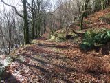
Path in Robin Hood Wood / David Brown; Geograph; Creative Commons.
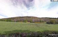
Robin Hood Wood seen from the southwest / Google Earth Street View.
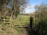
Bridleway in Robin Hood Wood / Adrian Taylor; Geograph; Creative Commons.
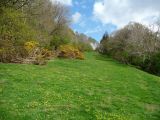
On the bridleway in Robin Hood Wood / Christine Johnstone; Geograph; Creative Commons.


