
Robin Hood (Standford): Difference between revisions
From International Robin Hood Bibliography
m (Text replacement - "<div class="no-img"><p id="byline">" to "<div class="no-img"> <p id="byline">") |
m (Text replacement - "No Copy in NLS" to "No copy in NLS") |
||
| (11 intermediate revisions by the same user not shown) | |||
| Line 1: | Line 1: | ||
__NOTOC__{{ | __NOTOC__{{PlaceNamesItemTop|Lat=51.105577|Lon=-0.835826|AdministrativeDivision=Hampshire|Vicinity=Standford Lane, Standford, Bordon|Type=Public house|Interest=Robin Hood name|Status=Defunct|Demonym=|Riding=|GreaterLondon=|Year=1881|Aka=|Century=|Cluster1=|Cluster2=|Cluster3=|Image=robin_hood_public_house_geograph.jpg|Postcards=|ExtraCat1=|ExtraCat2=|ExtraCat3=|ExtraCat4=|ExtraCat5=|ExtraLink1=|ExtraLink2=|ExtraLink3=|ExtraLink4=|ExtraLink5=|ExtraLinkName1=|ExtraLinkName2=|ExtraLinkName3=|ExtraLinkName4=|ExtraLinkName5=|GeopointPrefix=|GeopointSuffix=|StatusSuffix=|DatePrefix=|DateSuffix=}} | ||
{{#display_map:{{#var:Coords}}~{{#replace:{{PAGENAME}}|'|'}}|width=34% | {{#display_map:{{#var:Coords}}~{{#replace:{{PAGENAME}}|'|'}}|width=34%|enablefullscreen=yes}}<div class="pnMapLegend">The Robin Hood, now Whiteleys Family Restaurant.</div> | ||
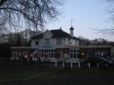
[[File:{{#var: | [[File:{{#var:Image}}|500px|thumb|right|The Robin Hood, Standford Lane / [http://www.geograph.org.uk/profile/28338 Shazz] Nov. 25, 2008, Creative Commons via | ||
Geograph.]]<div class="no-img"> | Geograph.]]<div class="no-img"> | ||
<p id="byline">By Henrik Thiil Nielsen, 2013-07-28. Revised by {{#realname:{{REVISIONUSER}}}}, {{REVISIONYEAR}}-{{REVISIONMONTH}}-{{REVISIONDAY2}}.</p> | <p id="byline">By Henrik Thiil Nielsen, 2013-07-28. Revised by {{#realname:{{REVISIONUSER}}}}, {{REVISIONYEAR}}-{{REVISIONMONTH}}-{{REVISIONDAY2}}.</p> | ||
The former Robin Hood in Standford is now Whiteleys Family Restaurant. Information on publicans for the years 1881-1927 can be found at UK Pub History.<ref>[https:// | The former Robin Hood in Standford is now Whiteleys Family Restaurant. Information on publicans for the years 1881-1927 can be found at UK Pub History.<ref>[https://pubwiki.co.uk/Hampshire/Headley/RobinHood.shtml UK Pub History: Robin Hood, Standford, Headley, Hampshire.]</ref>{{PlaceNamesItemAllusionsAndRecords}} | ||
== Gazetteers == | == Gazetteers == | ||
| Line 10: | Line 10: | ||
== Sources == | == Sources == | ||
* [https:// | * [https://pubwiki.co.uk/Hampshire/Headley/RobinHood.shtml UK Pub History: Robin Hood, Standford, Headley, Hampshire.] | ||
== Map == | == Map == | ||
* 25" O.S. map ''Hampshire and Isle of Wight'' XLIV.3 (''c.'' 1872; surveyed 1868-69). No | * 25" O.S. map ''Hampshire and Isle of Wight'' XLIV.3 (''c.'' 1872; surveyed 1868-69). No copy in NLS | ||
* 25" O.S. map ''Hampshire and Isle of Wight'' XLIV.3 (''c.'' 1897; rev. ''c.'' 1895). No | * 25" O.S. map ''Hampshire and Isle of Wight'' XLIV.3 (''c.'' 1897; rev. ''c.'' 1895). No copy in NLS | ||
* [https://maps.nls.uk/geo/explore/#zoom=18&lat=51.1054&lon=-0.8359&layers=168&b=5 25" O.S. map ''Hampshire'' and Isle of Wight XLIV.3 (1910; rev. 1909)] (georeferenced) | * [https://maps.nls.uk/geo/explore/#zoom=18&lat=51.1054&lon=-0.8359&layers=168&b=5 25" O.S. map ''Hampshire'' and Isle of Wight XLIV.3 (1910; rev. 1909)] (georeferenced) | ||
* [https://maps.nls.uk/view/105985297#zoom=5&lat=5475&lon=8679&layers=BT 25" O.S. map ''Hampshire'' and Isle of Wight XLIV.3 (1910; rev. 1909)] | * [https://maps.nls.uk/view/105985297#zoom=5&lat=5475&lon=8679&layers=BT 25" O.S. map ''Hampshire'' and Isle of Wight XLIV.3 (1910; rev. 1909)] | ||
| Line 21: | Line 21: | ||
* [https://maps.nls.uk/geo/explore/#zoom=16&lat=51.1066&lon=-0.8359&layers=6&b=5 6" O.S. map ''Surrey'' XLIV.NW & NE (1899; rev. 1895)] (georeferenced) | * [https://maps.nls.uk/geo/explore/#zoom=16&lat=51.1066&lon=-0.8359&layers=6&b=5 6" O.S. map ''Surrey'' XLIV.NW & NE (1899; rev. 1895)] (georeferenced) | ||
* [https://maps.nls.uk/view/101440767#zoom=5&lat=4835&lon=2910&layers=BT 6" O.S. map ''Hampshire'' & Isle of Wight XLIV.NE (1910; rev. 1909).] | * [https://maps.nls.uk/view/101440767#zoom=5&lat=4835&lon=2910&layers=BT 6" O.S. map ''Hampshire'' & Isle of Wight XLIV.NE (1910; rev. 1909).] | ||
{{ | {{PlaceNamesItemAlsoSee}} | ||
== Notes == | == Notes == | ||
| Line 28: | Line 28: | ||
<div id="gallery"> | <div id="gallery"> | ||
{{ | {{ImageGalleryIntroduction}} | ||
<gallery widths="195px"> | <gallery widths="195px"> | ||
whiteley's_standford_lane_standford_bordon_hampshire.jpg|Now: whiteley's, Standford Lane / proprietors via Google Earth. | whiteley's_standford_lane_standford_bordon_hampshire.jpg|Now: whiteley's, Standford Lane / proprietors via Google Earth. | ||
| Line 36: | Line 36: | ||
</div> | </div> | ||
{{ | {{PlaceNamesItemNavigation}} | ||
Revision as of 01:10, 13 February 2021
| Locality | |
|---|---|
| Coordinate | 51.105577, -0.835826 |
| Adm. div. | Hampshire |
| Vicinity | Standford Lane, Standford, Bordon |
| Type | Public house |
| Interest | Robin Hood name |
| Status | Defunct |
| First Record | 1881 |
The Robin Hood, now Whiteleys Family Restaurant.

The Robin Hood, Standford Lane / Shazz Nov. 25, 2008, Creative Commons via Geograph.
By Henrik Thiil Nielsen, 2013-07-28. Revised by Henrik Thiil Nielsen, 2021-02-13.
The former Robin Hood in Standford is now Whiteleys Family Restaurant. Information on publicans for the years 1881-1927 can be found at UK Pub History.[1]
Gazetteers
- Not included in Dobson, R. B., ed.; Taylor, J., ed. Rymes of Robyn Hood: an Introduction to the English Outlaw (London, 1976), pp. 293-311.
Sources
Map
- 25" O.S. map Hampshire and Isle of Wight XLIV.3 (c. 1872; surveyed 1868-69). No copy in NLS
- 25" O.S. map Hampshire and Isle of Wight XLIV.3 (c. 1897; rev. c. 1895). No copy in NLS
- 25" O.S. map Hampshire and Isle of Wight XLIV.3 (1910; rev. 1909) (georeferenced)
- 25" O.S. map Hampshire and Isle of Wight XLIV.3 (1910; rev. 1909)
- 6" O.S. map Hampshire & Isle of Wight XLIV (1872; surveyed 1869-70)
- 6" O.S. map Hampshire & Isle of Wight XLIV.NE (1898; rev. 1895)
- 6" O.S. map Surrey XLIV.NW & NE (1899; rev. 1895) (georeferenced)
- 6" O.S. map Hampshire & Isle of Wight XLIV.NE (1910; rev. 1909).
Also see
Notes
Image gallery
Click any image to display it in the lightbox, where you can navigate between images by clicking in the right or left side of the current image.

Now: whiteley's, Standford Lane / proprietors via Google Earth.
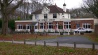
Whiteley's Family Restaurant, formerly the Robin Hood pub, in Standford / Shazz, 25 Nov. 2008, Creative Commons, via Geograph.
The Robin Hood, Standford Lane / David960, 29 Dec. 2013, Creative Commons, via Geograph.

