
Robin Hood's Stride (Harthill)
| Locality | |
|---|---|
| Coordinate | 53.156982, -1.666 |
| Adm. div. | Derbyshire |
| Vicinity | 1 km N of Elton |
| Type | Natural feature |
| Interest | Robin Hood name |
| Status | Extant |
| First Record | 1817 |
| A.k.a. | Mock Beggar's Hall |

By Henrik Thiil Nielsen, 2014-10-14. Revised by Henrik Thiil Nielsen, 2021-01-06.
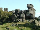
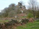
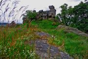
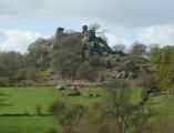
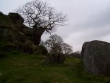
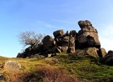
Robin Hood's Stride is the name of a formation of broken gritstone rocks on Hartle Moor close to the village of Elton. There is a pinnacle at either end of the formation, that to the west being known as the Weasel pinnacle and that to the east as the Inaccessible pinnacle.[1] The formation is said to owe its name to the belief that the distance between the two pinnacles was equal to the length of Robin Hood's step or stride.[2] The alternative name of Mock Beggar's Hall is probably due to the general resemblance of the entire formation to a hall (manor house) with each pinnacle as a 'chimney' at either end of the 'building'. One of two fairly early drawings of Robin Hood's Stride, dated respectively 1794 and 1804, is accompanied by a note about a tradition relating to Robin Hood (see Allusions below). However, the note does not actually include the name 'Robin Hood's Stride', though it may be included in the title of the drawing, if it has one. Until this has been verified, the 1817 allusion cited below must be considered the earliest certain source for the name.[3]
The note to the drawing just mentioned concerns a tradition that Robin Hood and Little John each shot an arrow from Eastwood Rocks (Ashover), one of which landed at Robin Hood's Stride. Similar traditions are connected with several ofther pairs of locailties. See the page on Places connected by bowshot.
As Kenneth Cameron notes in one of the English Place-Name Society volumes on Derbyshire, this and all other Robin Hood-related place-names in Derbyshire are first recorded at a late date.[4]
Robin Hood's Stride is a popular tourist attraction which has almost certainly been visited by more climbers than outlaws. Template:PlaceNamesItemQuery
Gazetteers
Sources
- Cameron, Kenneth. The Place-Names of Derbyshire (English Place-Name Society, vols. XXVII-XXIX) (Cambridge, 1959), vol. I, p. 109; pt. III, p. 760.
- Wikipedia: Robin Hood's Stride.
Maps
- 25" O.S. map Derbyshire XXVIII.12 (c. 1877; surveyed c. 1876). No Copy in NLS
- 25" O.S. map Derbyshire XXVIII.12 (1898; rev. 1897) (georeferenced)
- 25" O.S. map Derbyshire XXVIII.12 (1898; rev. 1897)
- 25" O.S. map Derbyshire XXVIII.12 (1922; rev. 1920)
- 6" O.S. map Derbyshire XXVIII.SE (1884; surveyed 1877-78)
- 6" O.S. map Derbyshire XXVIII.SE (1900; rev. 1897) (georeferenced)
- 6" O.S. map Derbyshire XXVIII.SE (1900; rev. 1897)
- 6" O.S. map Derbyshire XXVIII (1923; rev. 1919-20)
- 6" O.S. map Derbyshire XXVIII.SE (1923; rev. 1919-20)
- 1" O.S. map Sheet 111 (Hills) (1897)
- 1" O.S. map Sheet 111 (Outline) (1897).
Discussion
- Ackerley, Fred G. 'Robin Hood's Stride', Notes & Queries, Series 10, vol. II (1904), p. 246; suggests the hill was used as a fort in prehistoric times, possibly connected with the nearby 'Castle Ring' site.
Brief mention
- Brentnall, Margaret. 'Robin Hood of Sherwood Forest', [Unknown British travel and tourism magazine] (1963-12), pp. 15-17, 58, see p. 58
- Sandred Karl Inge; Lindström, Bengt, Cornford, B.; Rutledge, P.; Schram, O.K., compil. The Place-Names of Norfolk (English Place-Name Society, vols. LXI, LXXI, LXXIX) (Nottingham, 1989-2002), pt. III, p. xvii.
Notes
- ↑ Wikipedia: Robin Hood's Stride.
- ↑ Dobson, R. B., ed.; Taylor, J., ed. Rymes of Robyn Hood: an Introduction to the English Outlaw (London, 1976), p. 297.
- ↑ Cameron, Kenneth. The Place-Names of Derbyshire (English Place-Name Society, vols. XXVII-XXIX) (Cambridge, 1959), vol. I, p. 109.
- ↑ Cameron, Kenneth. The Place-Names of Derbyshire (English Place-Name Society, vols. XXVII-XXIX) (Cambridge, 1959), pt. III (vol. XXIX), p. 760.
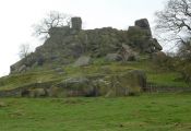
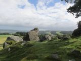
Robin Hood's Stride / J147, 11 Sep. 2007, Creative Commons, via Geograph.
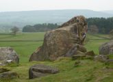
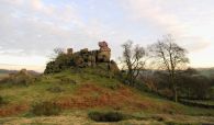
Robin Hood's Stride from the southeast / Andrew Hill, 11 Apr. 2011, Creative Commons, via Geograph.
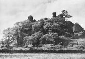
Robin Hood's Stride from the north / Tom Heyes, on or before 10 Jun. 2009, Attribution-No Derivative Works, via Panoramio.
Robin Hood's Stride / Andrew Hill, 12 Apr. 2011, Creative Commons, via Geograph.
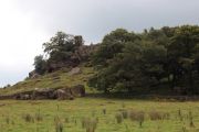
Robin Hood's Stride. 'Seen from the footpath approaching from the lane near Harthill Moor Farm' / Andrew Hill, 11 Apr. 2011, Creative Commons, via Geograph.
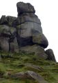
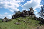
Robin Hood's Stride. western end of main formation / Andrew Hill, 11 Apr. 2011, Creative Commons, via Geograph.
Robin Hood's Stride / Graham Hogg, 20 jul. 2014, Creative Commons, via Geograph.
Outlying rocks at Robin Hood's Stride / Andrew Hill, 11 Apr. 2011, Creative Commons, via Geograph.
View of Robin Hood's Stride / Neil Theasby, 18 Jul. 2013, Creative Commons, via Geograph.
Rock outcrop at Robin Hood's Stride / Martin Speck, 3 May 2012, Creative Commons, via Geograph.

Robin Hood's Stride / J147, 11 Sep. 2007, Creative Commons, via Geograph.
Robin Hood's Stride / Brian Frost, 13 Mar. 2014, Creative Commons, via Geograph.
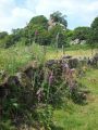
Robin Hood's Stride, from the footpath leading to it / Sam Styles, 2 May 2005, Creative Commons, via Geograph.
Rocks at Robin Hood's stride / Steven Ruffles, 8 Aug. 2016, Creative Commons, via Geograph.
Robin Hood's Stride / Darius Khan, 10 Jun. 2003, Creative Commons, via Geograph.
Robin Hood’s Stride at Sunset / Andrew Huggett, 21 Jan. 2006, Creative Commons, via Geograph.
Robin Hood's Stride / Plate from unknown book.
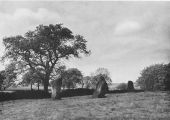
Stone circle near Robin Hood's Stride / Plate from unknown book.
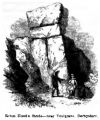
Robin Hood's Stride / Gutch, John Mathew, ed. A Lytell Geste of Robin Hode, with Other Ancient & Modern Ballads and Songs relating to this Celebrated Yeoman (London, 1847), vol. II, p. 225.
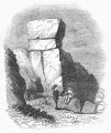
Robin Hood's Stride / C., A. 'The Old English Ballads.—Robin Hood.—No. VI', The Penny Magazine of the Society for the Diffusion of Useful Knowledge (1838), pp. 313-16, see p. 313; HTN collection.


