
Robin Hood's Chair (Kirkby in Ashfield): Difference between revisions
m (Text replacement - "<div class="no-img"><p id="byline">" to "<div class="no-img"> <p id="byline">") |
mNo edit summary |
||
| Line 1: | Line 1: | ||
__NOTOC__{{PnItemTop|Lat=53.0865|Lon=-1.2304|AdmDiv=Nottinghamshire|Vicinity=2.9 km SSE of Kirkby in Ashfield|Type=Natural feature|Interest=Robin Hood name|Status=Extant|Demonym=|Riding=|GreaterLondon=|Year=1774|Aka=|Century=|Cluster1=Kirkby in Ashfield|Cluster2=|Cluster3=|Image= | __NOTOC__{{PnItemTop|Lat=53.0865|Lon=-1.2304|AdmDiv=Nottinghamshire|Vicinity=2.9 km SSE of Kirkby in Ashfield|Type=Natural feature|Interest=Robin Hood name|Status=Extant|Demonym=|Riding=|GreaterLondon=|Year=1774|Aka=|Century=|Cluster1=Kirkby in Ashfield|Cluster2=|Cluster3=|Image=robin-hoods-chair-annesley-rich-3.jpg|Postcards=|ExtraCat1=Places named Robin Hood's Chair|ExtraCat2=|ExtraCat3=|ExtraCat4=|ExtraCat5=|ExtraLink1=|ExtraLink2=|ExtraLink3=|ExtraLink4=|ExtraLink5=|ExtraLinkName1=|ExtraLinkName2=|ExtraLinkName3=|ExtraLinkName4=|ExtraLinkName5=|GeopointPrefix=|GeopointSuffix=|StatusSuffix=?|DatePrefix=|DateSuffix=}} | ||
{{#display_map:{{#var:Coords}}~{{#replace:{{PAGENAME}}|'|'}}|width=34%|service=leaflet|enablefullscreen=yes}}<div class="pnMapLegend">Robin Hood's Chair.</div> | {{#display_map:{{#var:Coords}}~{{#replace:{{PAGENAME}}|'|'}}|width=34%|service=leaflet|enablefullscreen=yes}}<div class="pnMapLegend">Robin Hood's Chair.</div> | ||
[[File: | [[File:{{#var:Pnimage}}|thumb|right|500px|Robin Hood's Chair / [http://www.picturethepast.org.uk/frontend.php?keywords=Ref_No_increment;EQUALS;NTGM021731&pos=1&action=zoom&id=126269 S. Clements]).]]<div class="no-img"> | ||
<p id="byline">By Henrik Thiil Nielsen, 2016-10-04. Revised by {{#realname:{{REVISIONUSER}}}}, {{REVISIONYEAR}}-{{REVISIONMONTH}}-{{REVISIONDAY2}}.</p> | <p id="byline">By Henrik Thiil Nielsen, 2016-10-04. Revised by {{#realname:{{REVISIONUSER}}}}, {{REVISIONYEAR}}-{{REVISIONMONTH}}-{{REVISIONDAY2}}. Photos and information kindly provided by Rich.</p> | ||
Robin Hood's Chair is a rock located about 100 m due south of [[Robin Hood's Hills (Kirkby in Ashfield)|Robin Hood's Hills]] in Kirkby Forest, not quite 3 km SSE of Kirkby in Ashfield, Nottinghamshire, an area that was once part of Sherrwood Forest. About 640 m SW of these two localities is [[Robin Hood's Cave (Kirkby in Ashfield)|Robin Hood's Cave]]. Some 1.25 km SSW of them, just east of Annesley, was the [[Robin Hood (Kirkby in Ashfield)|Robin Hood]] public house. Robin Hood's Chair, it would seem, was rediscovered on 22 April 1917 by a Mr J.H. Pointon of Hucknall.<ref>[http://www.picturethepast.org.uk/frontend.php?keywords=Ref_No_increment;EQUALS;NTGM021731&pos=1&action=zoom&id=126269 Picture the Past].</ref> | Robin Hood's Chair is a rock located about 100 m due south of [[Robin Hood's Hills (Kirkby in Ashfield)|Robin Hood's Hills]] in Kirkby Forest, not quite 3 km SSE of Kirkby in Ashfield, Nottinghamshire, an area that was once part of Sherrwood Forest. About 640 m SW of these two localities is [[Robin Hood's Cave (Kirkby in Ashfield)|Robin Hood's Cave]]. Some 1.25 km SSW of them, just east of Annesley, was the [[Robin Hood (Kirkby in Ashfield)|Robin Hood]] public house. Robin Hood's Chair, it would seem, was rediscovered on 22 April 1917 by a Mr J.H. Pointon of Hucknall.<ref>[http://www.picturethepast.org.uk/frontend.php?keywords=Ref_No_increment;EQUALS;NTGM021731&pos=1&action=zoom&id=126269 Picture the Past].</ref> | ||
The name "Robin Hood's Chair" is first recorded on John Chapman's map of Nottinghamshire, surveyed 1774 and published 1776.<ref>{{:Chapman, John 1776a}}; not seen, but cf. {{:Gover, John Eric Bruce 1940a}}, p. 122. {{:Dobson, Richard Barrie 1976a}}, p. 302, ''s.n.'' 'Robin Hood's Hills', incorrectly refer to "Chapman and André's 1775 ''Map of Nottinghamshire''" (their italics).</ref>{{PnItemQry}} | The name "Robin Hood's Chair" is first recorded on John Chapman's map of Nottinghamshire, surveyed 1774 and published 1776.<ref>{{:Chapman, John 1776a}}; not seen, but cf. {{:Gover, John Eric Bruce 1940a}}, p. 122. {{:Dobson, Richard Barrie 1976a}}, p. 302, ''s.n.'' 'Robin Hood's Hills', incorrectly refer to "Chapman and André's 1775 ''Map of Nottinghamshire''" (their italics).</ref> | ||
Thanks to IRHB user Rich we now have fresh photos of the site. He was only able to pay a short visit to the site: 'I also had a wander down to Robin Hood's Chair, and took a couple of photos there too. I couldn't see anything that matched with the sketch on your site [...]'. | |||
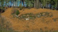
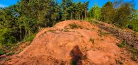
The sixth photo shows the little prominence which leads out to where Robin Hood's Chair is marked on the OS map, overlooking the golf course. The seventh photo shows the most obvious rock outcrop on the prominence, which was at the top and had a good view of the surrounding land. I only got a short time to look around but I couldn't see anything that resembled the picture on your website, so maybe I missed the actual area. However, I've had a look back at some old photos from when I first visited the area and if you zoom into the eighth photo at the bottom of the outcrop can make out a shape which looks a little like the shape in the picture on your site. | |||
{{PnItemQry}} | |||
== Gazetteers == | == Gazetteers == | ||
* {{:Dobson, Richard Barrie 1976a}}, p. 302, ''s.n.'' 'Robin Hood's Hills'. | * {{:Dobson, Richard Barrie 1976a}}, p. 302, ''s.n.'' 'Robin Hood's Hills'. | ||
| Line 32: | Line 39: | ||
== Notes == | == Notes == | ||
<references/> | <references/> | ||
</div> | |||
<div id="gallery"> | |||
{{ImgGalleryIntro}} | |||
<gallery widths="195px"> | |||
robin-hoods-chair-annesley-rich-3.jpg| | |||
robin-hoods-chair-annesley-rich-2.jpg| | |||
robin-hoods-chair-annesley-rich.jpg| | |||
Robin hoods chair kirkby in ashfield.jpg|Robin Hood's Chair / [http://www.picturethepast.org.uk/frontend.php?keywords=Ref_No_increment;EQUALS;NTGM021731&pos=1&action=zoom&id=126269 S. Clements]. | |||
</gallery> | |||
</div> | |||
{{PnItemNav}} | {{PnItemNav}} | ||
Revision as of 17:53, 19 May 2020
[[File:|thumb|right|500px|Robin Hood's Chair / S. Clements).]]
By Henrik Thiil Nielsen, 2016-10-04. Revised by Henrik Thiil Nielsen, 2020-05-19. Photos and information kindly provided by Rich.
Robin Hood's Chair is a rock located about 100 m due south of Robin Hood's Hills in Kirkby Forest, not quite 3 km SSE of Kirkby in Ashfield, Nottinghamshire, an area that was once part of Sherrwood Forest. About 640 m SW of these two localities is Robin Hood's Cave. Some 1.25 km SSW of them, just east of Annesley, was the Robin Hood public house. Robin Hood's Chair, it would seem, was rediscovered on 22 April 1917 by a Mr J.H. Pointon of Hucknall.[1]
The name "Robin Hood's Chair" is first recorded on John Chapman's map of Nottinghamshire, surveyed 1774 and published 1776.[2]
Thanks to IRHB user Rich we now have fresh photos of the site. He was only able to pay a short visit to the site: 'I also had a wander down to Robin Hood's Chair, and took a couple of photos there too. I couldn't see anything that matched with the sketch on your site [...]'.
The sixth photo shows the little prominence which leads out to where Robin Hood's Chair is marked on the OS map, overlooking the golf course. The seventh photo shows the most obvious rock outcrop on the prominence, which was at the top and had a good view of the surrounding land. I only got a short time to look around but I couldn't see anything that resembled the picture on your website, so maybe I missed the actual area. However, I've had a look back at some old photos from when I first visited the area and if you zoom into the eighth photo at the bottom of the outcrop can make out a shape which looks a little like the shape in the picture on your site.
Gazetteers
- Dobson, R. B., ed.; Taylor, J., ed. Rymes of Robyn Hood: an Introduction to the English Outlaw (London, 1976), p. 302, s.n. 'Robin Hood's Hills'.
Sources
- Gover, J.E.B.; Mawer, Allen; Stenton, F.M. The Place-Names of Nottinghamshire (English Place-Name Society, vol. XVII) (Cambridge, 1940), pp. 122, 294.
Maps
- Chapman, John, cartog. Nottingham Shire Survey'd in 1774 ([London], 1776). Not seen, but cf. J.E.B. Gover, cited under Sources above
- 25" O.S. map Nottinghamshire XXVII.16 (1900; rev. 1898) (georeferenced)
- 25" O.S. map Nottinghamshire XXVII.16 (1878; surveyed 1877-78)
- 25" O.S. map Nottinghamshire XXVII.16 (1900; rev. 1898)
- 25" O.S. map Nottinghamshire XXVII.16 (1916; rev. 1913)
- 25" O.S. map Nottinghamshire XXVII.16 (1947; rev. 1938)
- 6" O.S. map Nottinghamshire XXVII.SE (1886; surveyed 1877-78)
- 6" O.S. map Nottinghamshire XXVII.SE (1900; rev. 1898)
- 6" O.S. map Nottinghamshire XXVII.SE (1900; rev. 1898) (georeferenced)
- 6" O.S. map Nottinghamshire XXVII.SE (1921; rev. 1913-14)
- 6" O.S. map Nottinghamshire XXVII.SE (c. 1949; rev. 1938).
Backgrounds
Notes
- ↑ Picture the Past.
- ↑ Chapman, John, cartog. Nottingham Shire Survey'd in 1774 ([London], 1776); not seen, but cf. Gover, J.E.B.; Mawer, Allen; Stenton, F.M. The Place-Names of Nottinghamshire (English Place-Name Society, vol. XVII) (Cambridge, 1940), p. 122. Dobson, R. B., ed.; Taylor, J., ed. Rymes of Robyn Hood: an Introduction to the English Outlaw (London, 1976), p. 302, s.n. 'Robin Hood's Hills', incorrectly refer to "Chapman and André's 1775 Map of Nottinghamshire" (their italics).
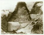
Robin Hood's Chair / S. Clements.


