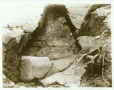
Robin Hood's Chair (Kirkby in Ashfield): Difference between revisions
From International Robin Hood Bibliography
mNo edit summary |
m (→Maps) |
||
| Line 17: | Line 17: | ||
* [http://maps.nls.uk/view/101602755#zoom=5&lat=2409&lon=5171&layers=BT 6" O.S. map ''Nottinghamshire'' XXVII.SE (1886; surveyed 1877-78)]. | * [http://maps.nls.uk/view/101602755#zoom=5&lat=2409&lon=5171&layers=BT 6" O.S. map ''Nottinghamshire'' XXVII.SE (1886; surveyed 1877-78)]. | ||
* [http://maps.nls.uk/view/101602752#zoom=5&lat=2286&lon=4980&layers=BT 6" O.S. map ''Nottinghamshire'' XXVII.SE (1900; rev. 1898)]. | * [http://maps.nls.uk/view/101602752#zoom=5&lat=2286&lon=4980&layers=BT 6" O.S. map ''Nottinghamshire'' XXVII.SE (1900; rev. 1898)]. | ||
* [http://maps.nls.uk/geo/explore/#zoom=16&lat=53.0865&lon=-1.2307&layers=6&b=5 6" O.S. map ''Nottinghamshire'' XXVII.SE (1900; rev. 1898)] (georeferenced) | |||
* [http://maps.nls.uk/view/101602749#zoom=4&lat=2608&lon=5282&layers=BT 6" O.S. map ''Nottinghamshire'' XXVII.SE (1921; rev. 1913-14)]. | * [http://maps.nls.uk/view/101602749#zoom=4&lat=2608&lon=5282&layers=BT 6" O.S. map ''Nottinghamshire'' XXVII.SE (1921; rev. 1913-14)]. | ||
* [http://maps.nls.uk/view/101602746#zoom=4&lat=2575&lon=5227&layers=BT 6" O.S. map ''Nottinghamshire'' XXVII.SE (''c.'' 1949; rev. 1938)]. | * [http://maps.nls.uk/view/101602746#zoom=4&lat=2575&lon=5227&layers=BT 6" O.S. map ''Nottinghamshire'' XXVII.SE (''c.'' 1949; rev. 1938)]. | ||
* [http://maps.nls.uk/geo/explore/#zoom=17&lat=53.0868&lon=-1.2299&layers=168&b=5 25" O.S. map ''Nottinghamshire'' XXVII.16 (1900; rev. 1898)] (georeferenced) | |||
* [https://maps.nls.uk/view/115390820#zoom=4&lat=5027&lon=2629&layers=BT 25" O.S. map ''Nottinghamshire'' XXVII.16 (1878; surveyed 1877-78)] | |||
* [https://maps.nls.uk/view/115390823#zoom=4&lat=4796&lon=2849&layers=BT 25" O.S. map ''Nottinghamshire'' XXVII.16 (1900; rev. 1898)] | |||
* [https://maps.nls.uk/view/115390826#zoom=4&lat=5048&lon=2844&layers=BT 25" O.S. map ''Nottinghamshire'' XXVII.16 (1916; rev. 1913)] | |||
* [https://maps.nls.uk/view/115390829#zoom=4&lat=4923&lon=2719&layers=BT 25" O.S. map ''Nottinghamshire'' XXVII.16 (1947; rev. 1938).] | |||
== Backgrounds == | == Backgrounds == | ||
* [http://www.picturethepast.org.uk/frontend.php?keywords=Ref_No_increment;EQUALS;NTGM021731&pos=1&action=zoom&id=126269 Picture the Past]. | * [http://www.picturethepast.org.uk/frontend.php?keywords=Ref_No_increment;EQUALS;NTGM021731&pos=1&action=zoom&id=126269 Picture the Past]. | ||
Revision as of 17:56, 23 May 2018
Approximate location of Robin Hood's Chair.

Robin Hood's Chair (photo: S. CLements).
By Henrik Thiil Nielsen, 2016-10-04. Revised by Henrik Thiil Nielsen, 2018-05-23.
Robin Hood's Chair is a rock located about 100 m due S of Robin Hood's Hills in Kirkby Forest, not quite 3 km SSE of Kirkby in Ashfield, Nottinghamshire, an area that was once part of Sherrwood Forest. About 640 m SW of these two localities is Robin Hood's Cave. Some 1.25 km SSW of them, just east of Annesley, was the Robin Hood public house. Robin Hood's Chair, it would seem, was rediscovered on 22 April 1917 by a Mr J.H. Pointon of Hucknall.[1]
The name "Robin Hood's Chair" is first recorded on John Chapman's map of Nottinghamshire, surveyed 1774 and published 1776.[2]
Gazetteers
- Dobson, R. B., ed.; Taylor, J., ed. Rymes of Robyn Hood: an Introduction to the English Outlaw (London, 1976), p. 302, s.n. 'Robin Hood's Hills'
- Gover, J.E.B.; Mawer, Allen; Stenton, F.M. The Place-Names of Nottinghamshire (English Place-Name Society, vol. XVII) (Cambridge, 1940), pp. 122, 294.
Sources
Maps
- Chapman, John, cartog. Nottingham Shire Survey'd in 1774 ([London], 1776). Not seen, but cf. J.E.B. Gover, cited under Sources above.
- 6" O.S. map Nottinghamshire XXVII.SE (1886; surveyed 1877-78).
- 6" O.S. map Nottinghamshire XXVII.SE (1900; rev. 1898).
- 6" O.S. map Nottinghamshire XXVII.SE (1900; rev. 1898) (georeferenced)
- 6" O.S. map Nottinghamshire XXVII.SE (1921; rev. 1913-14).
- 6" O.S. map Nottinghamshire XXVII.SE (c. 1949; rev. 1938).
- 25" O.S. map Nottinghamshire XXVII.16 (1900; rev. 1898) (georeferenced)
- 25" O.S. map Nottinghamshire XXVII.16 (1878; surveyed 1877-78)
- 25" O.S. map Nottinghamshire XXVII.16 (1900; rev. 1898)
- 25" O.S. map Nottinghamshire XXVII.16 (1916; rev. 1913)
- 25" O.S. map Nottinghamshire XXVII.16 (1947; rev. 1938).
Backgrounds
Notes
- ↑ Picture the Past.
- ↑ Chapman, John, cartog. Nottingham Shire Survey'd in 1774 ([London], 1776); not seen, but cf. Gover, J.E.B.; Mawer, Allen; Stenton, F.M. The Place-Names of Nottinghamshire (English Place-Name Society, vol. XVII) (Cambridge, 1940), p. 122. Dobson, R. B., ed.; Taylor, J., ed. Rymes of Robyn Hood: an Introduction to the English Outlaw (London, 1976), p. 302, s.n. 'Robin Hood's Hills', incorrectly refer to "Chapman and André's 1775 Map of Nottinghamshire" (their italics).
