Robin Hood's Cave (Kirkby in Ashfield): Difference between revisions
From International Robin Hood Bibliography
m (Text replacement - "=== Gazetteers ===" to "== Gazetteers ==") |
m (Text replacement - "=== Maps ===" to "== Maps ==") |
||
| Line 9: | Line 9: | ||
* {{:Dobson, Richard Barrie 1976a}}, p. 302, ''s.n.'' 'Robin Hood's Cave' [II] and 'Robin Hood's Hills' | * {{:Dobson, Richard Barrie 1976a}}, p. 302, ''s.n.'' 'Robin Hood's Cave' [II] and 'Robin Hood's Hills' | ||
* {{:Gover, John Eric Bruce 1940a}}, pp. 64, 294. | * {{:Gover, John Eric Bruce 1940a}}, pp. 64, 294. | ||
== Maps == | |||
* [http://maps.nls.uk/view/101602755#zoom=5&lat=2409&lon=5171&layers=BT 6" O.S. map ''Nottinghamshire'' XXVII.SE (1886; surveyed 1877-78)] | * [http://maps.nls.uk/view/101602755#zoom=5&lat=2409&lon=5171&layers=BT 6" O.S. map ''Nottinghamshire'' XXVII.SE (1886; surveyed 1877-78)] | ||
* [http://maps.nls.uk/view/101602752#zoom=5&lat=2286&lon=4980&layers=BT 6" O.S. map ''Nottinghamshire'' XXVII.SE (1900; rev. 1898)] | * [http://maps.nls.uk/view/101602752#zoom=5&lat=2286&lon=4980&layers=BT 6" O.S. map ''Nottinghamshire'' XXVII.SE (1900; rev. 1898)] | ||
Revision as of 14:36, 12 July 2018
Robin Hood's Chair.

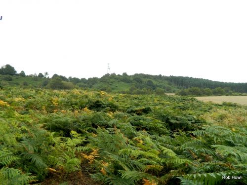
Robin Hood's Cave is hidden somewhere under the bracken (photo by Rob Howl, from Panoramio – no longer online).
By Henrik Thiil Nielsen, 2016-10-04. Revised by Henrik Thiil Nielsen, 2018-07-12.
Now said to be below ground,[1] Robin Hood's Cave was (is) located by a path immediately east of Derby Road, some 1.5 km SSE of central Kirkby in Ashfield. About 700 m NE of the site of the cave are found Robin Hood's Hills and Robin Hood's Chair, while the Robin Hood, a public house, could once be frequented about 600 m S of the Cave, just south of Annesley at what was then a crossroads but is now the corner of Derby Road and Forest Road. The earliest source for this place-name would seem to be an O.S. map from c. 1825.[2]
Gazetteers
- Dobson, R. B., ed.; Taylor, J., ed. Rymes of Robyn Hood: an Introduction to the English Outlaw (London, 1976), p. 302, s.n. 'Robin Hood's Cave' [II] and 'Robin Hood's Hills'
- Gover, J.E.B.; Mawer, Allen; Stenton, F.M. The Place-Names of Nottinghamshire (English Place-Name Society, vol. XVII) (Cambridge, 1940), pp. 64, 294.
Maps
- 6" O.S. map Nottinghamshire XXVII.SE (1886; surveyed 1877-78)
- 6" O.S. map Nottinghamshire XXVII.SE (1900; rev. 1898)
- 6" O.S. map Nottinghamshire XXVII.SE (1900; rev. 1898) (georeferenced)
- 6" O.S. map Nottinghamshire XXVII.SE (1921; rev. 1913-14)
- 6" O.S. map Nottinghamshire XXVII.SE (c. 1949; rev. 1938)
- 25" O.S. map Nottinghamshire XXVII.15 (1900; rev. 1898) (georeferenced)
- 25" O.S. map Nottinghamshire XXVII.15 (1879; surveyed 1877)
- 25" O.S. map Nottinghamshire XXVII.15 (1900; rev. 1898)
- 25" O.S. map Nottinghamshire XXVII.15 (c. 1917; rev. c. 1914). No Copy in NLS
- 25" O.S. map Nottinghamshire XXVII.15 (1945; rev. 1938)
- 6" O.S. map Derbyshire XXXVI (1921; rev. 1913-14).
Background
Notes
