
Little John Street (Manchester): Difference between revisions
m (Text replacement - "Creative Commons via Geograph" to "Creative Commons, via Geograph") |
m (→Maps) |
||
| Line 11: | Line 11: | ||
* --> | * --> | ||
== Maps == | == Maps == | ||
* 25" O.S. map ''Lancashire'' CIV.10 (''c.'' 1893; surveyed ''c.'' 1889-91). No Copy in NLS | |||
* 25" O.S. map ''Lancashire'' CIV.10 (''c.'' 1908; rev. ''c.'' 1904). No Copy in NLS | |||
* [https://maps.nls.uk/geo/explore/#zoom=18&lat=53.4788&lon=-2.2547&layers=168&b=5 25" O.S. map ''Lancashire'' CIV.10 (1922; rev. 1915-16)] (georeferenced) | |||
* [https://maps.nls.uk/view/126522836#zoom=5&lat=9252&lon=8375&layers=BT 25" O.S. map ''Lancashire'' CIV.10 (1922; rev. 1915-16)] | |||
* [https://maps.nls.uk/view/126522839#zoom=5&lat=9306&lon=8240&layers=BT 25" O.S. map ''Lancashire'' CIV.10 (1934; rev. 1932)] | |||
* [https://maps.nls.uk/geo/explore/#zoom=16&lat=53.4787&lon=-2.2566&layers=6&b=5 6" O.S. map ''Lancashire'' CIV.SW (1909; rev. 1905)] (georeferenced) | * [https://maps.nls.uk/geo/explore/#zoom=16&lat=53.4787&lon=-2.2566&layers=6&b=5 6" O.S. map ''Lancashire'' CIV.SW (1909; rev. 1905)] (georeferenced) | ||
* [https://maps.nls.uk/view/102344087#zoom=6&lat=4695&lon=5745&layers=BT 6" O.S. map ''Lancashire'' CIV (1848; surveyed 1845)] | * [https://maps.nls.uk/view/102344087#zoom=6&lat=4695&lon=5745&layers=BT 6" O.S. map ''Lancashire'' CIV (1848; surveyed 1845)] | ||
| Line 18: | Line 23: | ||
* [https://maps.nls.uk/view/101103806#zoom=5&lat=5652&lon=6265&layers=BT 6" O.S. map ''Lancashire'' CIV.SW (1923; rev. 1915-16)] | * [https://maps.nls.uk/view/101103806#zoom=5&lat=5652&lon=6265&layers=BT 6" O.S. map ''Lancashire'' CIV.SW (1923; rev. 1915-16)] | ||
* [https://maps.nls.uk/view/101103803#zoom=5&lat=5745&lon=6317&layers=BT 6" O.S. map ''Lancashire'' CIV.SW (1936; rev. 1931-32)] | * [https://maps.nls.uk/view/101103803#zoom=5&lat=5745&lon=6317&layers=BT 6" O.S. map ''Lancashire'' CIV.SW (1936; rev. 1931-32)] | ||
* [https://maps.nls.uk/view/102339522#zoom=5&lat=5623&lon=6328&layers=BT 6" O.S. map ''Lancashire'' CIV.SW (''c.'' 1946; rev. 1938 | * [https://maps.nls.uk/view/102339522#zoom=5&lat=5623&lon=6328&layers=BT 6" O.S. map ''Lancashire'' CIV.SW (''c.'' 1946; rev. 1938).] | ||
<!--== Discussion == | <!--== Discussion == | ||
* --> | * --> | ||
Revision as of 11:35, 31 May 2019
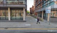
[[File:|thumb|right|380px|Little John Street, running S–N from Great John Street to Quay Street / Gerald England, 14 Jul. 2018, Creative Commons, via Geograph.]]
By Henrik Thiil Nielsen, 2019-03-05. Revised by Henrik Thiil Nielsen, 2019-05-31.
Little John Street which runs north from Great John Street to Quay Street, Manchester, is such a humble little street its name is only included on 25" O.S. maps, not the 6" maps. It is labelled "Little John Street" on the 25" map published 1923, based on a revision carried out 1915-16. The 25" maps from c. 1893 and c. 1908 are not online. The street may be included in one or both of these. Since Little John Street is a side street of Great John Street, someone obviously had a sense of humour. Template:PnItemQry
Gazetteers
- Not included in Dobson, R. B., ed.; Taylor, J., ed. Rymes of Robyn Hood: an Introduction to the English Outlaw (London, 1976), pp. 293-311.
Maps
- 25" O.S. map Lancashire CIV.10 (c. 1893; surveyed c. 1889-91). No Copy in NLS
- 25" O.S. map Lancashire CIV.10 (c. 1908; rev. c. 1904). No Copy in NLS
- 25" O.S. map Lancashire CIV.10 (1922; rev. 1915-16) (georeferenced)
- 25" O.S. map Lancashire CIV.10 (1922; rev. 1915-16)
- 25" O.S. map Lancashire CIV.10 (1934; rev. 1932)
- 6" O.S. map Lancashire CIV.SW (1909; rev. 1905) (georeferenced)
- 6" O.S. map Lancashire CIV (1848; surveyed 1845)
- 6" O.S. map Lancashire CIV.SW (1896; surveyed 1894)
- 6" O.S. map Lancashire CIV.SW (1909; rev. 1905)
- 6" O.S. map Lancashire CIV (1923; rev. 1915-21)
- 6" O.S. map Lancashire CIV.SW (1923; rev. 1915-16)
- 6" O.S. map Lancashire CIV.SW (1936; rev. 1931-32)
- 6" O.S. map Lancashire CIV.SW (c. 1946; rev. 1938).

Little John Street, leading S–N from Great John Street to Quay Street / Gerald England, 14 Jul. 2018, Creative Commons, via Geograph.

On Great John Street, looking north into Little John Street.
On Quay Street, looking south into Little John Street.


