Little John Close (New Ollerton): Difference between revisions
From International Robin Hood Bibliography
m (Text replacement - "ImgGalleryIntro" to "ImageGalleryIntroduction") |
m (Text replacement - "No Copy in NLS" to "No copy in NLS") |
||
| Line 10: | Line 10: | ||
== Maps == | == Maps == | ||
* [https://maps.nls.uk/view/115390084#zoom=3&lat=3191&lon=7383&layers=BT 25" O.S. map ''Nottinghamshire'' XIX.10 (1885; surveyed 1884)] | * [https://maps.nls.uk/view/115390084#zoom=3&lat=3191&lon=7383&layers=BT 25" O.S. map ''Nottinghamshire'' XIX.10 (1885; surveyed 1884)] | ||
* 25" O.S. map ''Nottinghamshire'' XIX.10 (''c.'' 1899; ''c.'' 1897-98). No | * 25" O.S. map ''Nottinghamshire'' XIX.10 (''c.'' 1899; ''c.'' 1897-98). No copy in NLS | ||
* [https://maps.nls.uk/view/115390087#zoom=3&lat=3391&lon=8146&layers=BT 25" O.S. map ''Nottinghamshire'' XIX.10 (1920; rev. 1915)] | * [https://maps.nls.uk/view/115390087#zoom=3&lat=3391&lon=8146&layers=BT 25" O.S. map ''Nottinghamshire'' XIX.10 (1920; rev. 1915)] | ||
* [http://maps.nls.uk/geo/explore/#zoom=18&lat=53.2137&lon=-1.0016&layers=168&b=5 25" O.S. map ''Nottinghamshire'' XIX.10 (1920; rev. 1915)] (georeferenced) | * [http://maps.nls.uk/geo/explore/#zoom=18&lat=53.2137&lon=-1.0016&layers=168&b=5 25" O.S. map ''Nottinghamshire'' XIX.10 (1920; rev. 1915)] (georeferenced) | ||
Latest revision as of 01:02, 13 February 2021
| Locality | |
|---|---|
| Coordinate | 53.213217, -1.001428 |
| Adm. div. | Nottinghamshire |
| Vicinity | Side street on N side of Hallam Road |
| Type | Thoroughfare |
| Interest | Robin Hood name |
| Status | Extant |
| First Record | |
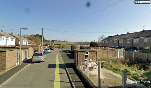
Little John Close, New Ollerton
By Henrik Thiil Nielsen, 2018-05-22. Revised by Henrik Thiil Nielsen, 2021-02-13.
Little John Close is a residential cul-de-sac on the north side of Hallam Road in New Ollerton.
As the street is not included on late-19th to mid-20th century O.S. maps, it was most probably constructed in the latter half of the 20th century.
Maps
- 25" O.S. map Nottinghamshire XIX.10 (1885; surveyed 1884)
- 25" O.S. map Nottinghamshire XIX.10 (c. 1899; c. 1897-98). No copy in NLS
- 25" O.S. map Nottinghamshire XIX.10 (1920; rev. 1915)
- 25" O.S. map Nottinghamshire XIX.10 (1920; rev. 1915) (georeferenced)
- 25" O.S. map Nottinghamshire XIX.10 (1945; rev. 1938).
- 6" O.S. map Nottinghamshire XIX.SW (1884; surveyed 1882)
- 6" O.S. map Nottinghamshire XIX.SW (1900; rev. 1897-99)
- 6" O.S. map Nottinghamshire XIX.SW (1900; rev. 1897-99) (georeferenced)
- 6" O.S. map Nottinghamshire XIX.SW (1921; rev. 1915).
Also see

