
Little John's Shot (Dublin)
[[File:|thumb|right|500px|This football field is said to be what remains of Oxmantown Green; photographed from the premises of The Law Society of Ireland / Tweet by Hurdy Gurdy Museum.]]


By Henrik Thiil Nielsen, 2017-06-02. Revised by Henrik Thiil Nielsen, 2018-07-17.
Little John's Shot was a hillock on Oxmantown Green, from which, according to a tale or tradition reported in the first edition of Holinshed's Chronicles (1577), Little John shot an arrow, standing on Father Mathew Bridge, then known as Dublin Bridge (see 1577 Allusion below).
The chronicle reports that Little John went to Ireland after Robin Hood's death and stayed in Dublin for a few days. Eager for a demonstration of the visitor's prowess with the longbow, the Dubliners "requested hym hartily to trie how far he could shoote at randone [sic]". Little John obliged, the arrow landing at "that mole hill, leauyng behynde him a monument, rather by his posteritie to be woondered, then possibly by any man liuyng to be counterscored". Unfortunately this feat led to the authorities becoming aware of his presence, so he hastily left Ireland for Scotland.
According to someone representing Dublin's Hurdy Gurdy Museum,[1] the lawn with a football field located between the premises of the Law Society of Ireland (to the east) and Collins Barracks (to the west; now housing the National Museum of Ireland – Decorative Arts and History) is all that is left of Oxmantown Green. Judging from John Speed's map of 1610 and that of Herman Moll of 1714 (both shown on this page), it does seem likely that the green area with the football field was once part of Oxmantown Green. Little John's arrow, if it landed about the centre of the present football field, travelled c. 660 meters, but in view of the reputation of Robin Hood and his men in the archery department it is not unlikely the arrow was thought to have landed a good deal further west. The intriguing account of 'Scald brother' in the chronicle suggests that the Green was then a quite extensive area, and John Speed's 1610 map shows more green (Green?) west of the city, north of the river, than the 1714 map. I have, nonetheless, used the centre of the football field for the coordinates indicated in the infobox and on the Google map.
Readers of a more cynical than romantic cast of mind will perhaps tend to explain the story of Little John's flight shooting as an etiological myth serving to explain the presence of a possibly conspicuous hillock on the Green. I have entered this locality in the infobox as a natural feature. This is what the description in Holinshed seems to suggest, but it may of course have been a small mound. Template:PnItemQry
Gazetteers
- Outside scope of Dobson, R. B., ed.; Taylor, J., ed. Rymes of Robyn Hood: an Introduction to the English Outlaw (London, 1976), pp. 293-311.
Maps
Studies and criticism
Background
- Twitter: Remainder of Oxmantown Green (by Hurdy Gurdy Museum)
- Wikipedia: Collins Barracks
- Wikipedia: Father Mathew Bridge
- Wikipedia: National Museum of Ireland – Decorative Arts and History
- Wikipedia: Origin myth
- Wikipedia: Oxmantown.
Notes
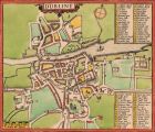
John Speed's map of Dublin, 1610; reprinted 1896 / Public domain, via Wikimedia Commons.
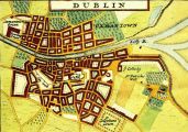
Oxmantown Green is seen in the upper-left corner of this Insert depicting Dublin in Herman Moll's map of Ireland (1714) (see Maps section) / Public domain, via South Dublin County Libraries.
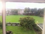
This football field is said to be what remains of Oxmantown Green; photographed from the premises of The Law Society of Ireland / Tweet by Hurdy Gurdy Museum.
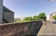
A peep from the Google StreetView car over the wall into the football said to be what remains of Oxmantown Green / Google StreetView.

